
The Hundred of Morgan is a hundred in the County of Dalhousie, South Australia. [1] The hundred was established 1876 but has no townships.
The Hundred of Morgan is a hundred in the County of Dalhousie, South Australia. [1] The hundred was established 1876 but has no townships.

Witjira National Park is a protected area in the Australian state of South Australia about 987 kilometres north of the state capital of Adelaide.
Dalhousie may refer to:
Dalhousie was a Canadian town located in Restigouche County, New Brunswick. New Brunswick's northernmost point of land is situated in Dalhousie, where the Restigouche River meets Chaleur Bay. The town has a population of 3,126 (2016).
Dalhousie Springs, also known as Witjira-Dalhousie Springs, is a group of over 60 natural artesian springs located in Witjira National Park on the western fringe of the Simpson Desert, 180 kilometres northeast of Oodnadatta in northern South Australia. They are about 250 kilometres (160 mi) southeast of Alice Springs.

Lands administrative divisions of Australia are the cadastral divisions of Australia for the purposes of identification of land to ensure security of land ownership. Most states term these divisions as counties, parishes, hundreds, and other terms. The eastern states of Queensland, New South Wales, Victoria, and Tasmania were divided into counties and parishes in the 19th century, although the Tasmanian counties were renamed land districts in the 20th century. Parts of South Australia (south-east) and Western Australia (south-west) were similarly divided into counties, and there were also five counties in a small part of the Northern Territory. However South Australia has subdivisions of hundreds instead of parishes, along with the Northern Territory, which was part of South Australia when the hundreds were proclaimed. There were also formerly hundreds in Tasmania. There have been at least 600 counties, 544 hundreds and at least 15,692 parishes in Australia, but there are none of these units for most of the sparsely inhabited central and western parts of the country.
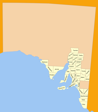
The lands administrative divisions of South Australia are the cadastral units of counties and hundreds in South Australia. They are located only in the south-eastern part of the state, and do not cover the whole state. 49 counties have been proclaimed across the southern and southeastern areas of the state historically considered to be arable and thus in need of a cadastre. Within that area, a total of 540 hundreds have been proclaimed, although five were annulled in 1870, and, in some cases, the names reused elsewhere.
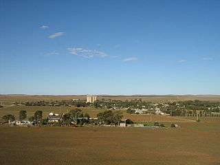
Yongala is a small town located in the state of South Australia, Australia. It has a population of approximately 240 people and is situated on the Clare-Peterborough Road (B79), 238 km from Adelaide, the state capital.

Dalhousie was an electoral district of the Legislative Assembly in the Australian state of Victoria from 1859 to 1927. It was based in north-western Victoria. The district had been named Electoral district of Anglesey. The district of Dalhousie was defined in the 1858 Electoral Act as :
THE ELECTORAL DISTRICT OF DALHOUSIE.
ANGLESEY. Bounded on the west by part of the eastern boundary of the County of Dalhousie, namely, by the River Goulburn from the confluence of Hughes's Creek to the confluence of Dabyminga Creek; thence by Dabyminga Creek to its source in the Great Dividing Range; on the south by the Great Dividing Range to the main source of the River Goulburn; on the east by the range dividing the waters of the main source of the Goulburn and Big Rivers from those of the Rubicon and Snod-por-dock Creek northward to Mount Torbrick; thence by Jerusalem Creek to its confluence with the River Goulburn; thence by the River Goulburn to the confluence of the River Delatite; thence by the River Delatite and its north-west arm to the Dividing Range between the last named arm and Septimus Creek; and on the north by that range to the source of Hughes's Creek; and thence by Hughes's Creek to its confluence with the River Goulburn, excepting the country included in the Boroughs of Seymour and Avenel ... DALHOUSIE. Commencing at the junction of the Rivers Campaspe and Coliban; thence by a line south-easterly to the source of the Mclvor or Patterson's Creek; thence by a line north-east to the confluence of Hughes's Creek with the River Goulburn; on the east by the River Goulburn until it joins the Dabyminga Creek, by that creek to its source in the Dividing Range; on
the south by the Dividing Range to the source of the River Coliban; and on the west by the last mentioned river to its junction with the River Campaspe, being the commencing point, excepting the country included in the electoral districts of the Kyneton Boroughs, Murray Boroughs, and Kilmore.
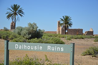
Dalhousie Station, most commonly known as Dalhousie Springs Station, was a pastoral lease that once operated as a cattle station in South Australia. Dalhousie and other surrounding leases were acquired by the Australian Government in 1985 to make up Witjira National Park.
The District Council of Orroroo was a local government area in South Australia, centred on the town of Orroroo. It was gazetted on 5 January 1888 under the provisions of the District Councils Act 1887 and included all the land defined by the hundreds of Black Rock Plain, Coomooroo, Erskine, Pekina, and Walloway in the County of Dalhousie.

County of Carnarvon is a cadastral unit located in the Australian state of South Australia which covers the full extent of Kangaroo Island. It was proclaimed in 1874 by Governor Musgrave in response to the demand for agriculture land on Kangaroo Island.
The County of Dalhousie is one of the 49 cadastral counties of South Australia in straddling the Mid North and Flinders Ranges regions. It was proclaimed in 1871 by Governor James Fergusson and was named for Fergusson's father-in-law James Broun-Ramsay, 1st Marquess of Dalhousie.
County of Dalhousie may refer to:

The Hundred of Yongala is a cadastral unit of hundred located in the Mid North of South Australia. It is one of the 12 hundreds of the County of Dalhousie and was proclaimed by Governor James Fergusson in 1871. The eponymous township of Yongala lies in the west of the hundred and the larger township of Peterborough in the north east. The locality of Sunnybrae occupies the remainder of the hundred.

The Hundred of Tarcowie is a cadastral unit of hundred located on the south western slopes of the Narien Range in the Mid North of South Australia spanning the township of Tarcowie, the locality of Hornsdale, and surrounds. One of the 12 hundreds of the County of Dalhousie, it was proclaimed in 1871 by Governor James Fergusson and named for an indigenous term thought to mean 'wash away water'.
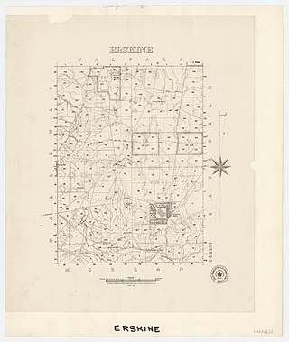
The Hundred of Erskine is a hundred in the County of Dalhousie, South Australia. The hundred was established 1876 but contains no townships.

The Hundred of Oladdie is a hundred in the County of Dalhousie, South Australia., South Australia. The hundred was established 1876 but has no townships. A settlement at Oladdie was abandoned.

The Hundred of Yalpara is a hundred in the County of Dalhousie, South Australia. The hundred was established 1876 and a government town called Brassey was laid out, though it never developed into a township. The hundred is largely occupied by the locality of Yalpara but a portion of Minburra crosses the western border.

County of Herbert is a cadastral unit located in the Australian state of South Australia that covers land to the east of the Flinders Ranges about 55 kilometres (34 mi) north-east of the town of Peterborough. It was proclaimed in 1877 and named after a prominent man of the time with either a title or a surname containing the name ‘Herbert’. It has been partially divided in the following sub-units of hundreds – Cavenagh, Coglin, Minburra, Nackara, Paratoo and Waroonee.

County of Kimberley is a cadastral unit located in the Australian state of South Australia that covers land to the east of the Flinders Ranges about 45 kilometres (28 mi) east of the town of Peterborough. It was proclaimed in 1871 and named after John Wodehouse, 1st Earl of Kimberley, a British Secretary of State for the Colonies. It has been partially divided in the following sub-units of hundreds – Gumbowie, Hardy, Ketchowla, Parnaroo, Terowie and Wonna.
| | This South Australia geography article is a stub. You can help Wikipedia by expanding it. |