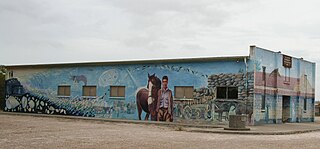
Kingston On Murray is a town on the south bank of the Murray River in the Riverland region of South Australia. Its name is ultimately derived from Charles Kingston who was Premier of South Australia from 1893 to 1899. At the 2006 census, the town had a population of 257.

Michael Kevin O'Loughlin is a former professional Australian rules footballer, who played his entire Australian Football League career with the Sydney Swans.
Yuendumu is a town in the Northern Territory of Australia, 293 km (182 mi) northwest of Alice Springs on the Tanami Road, within the Central Desert Region local government area. It ranks as one of the larger remote communities in central Australia, and has a thriving community of Aboriginal artists. It is home to Pintubi Anmatjere Warlpiri (PAW) Media, which produced the TV series Bush Mechanics.

The Adnyamathanha are a contemporary Aboriginal Australian people of the northern Flinders Ranges, South Australia, formed as an aggregate of several distinct peoples. Strictly speaking the ethnonym Adnyamathanha was an alternative name for the Wailpi, but the grouping also includes the Guyani, Jadliaura, Pilatapa and sometimes the Barngarla peoples. The origin of the name is in the words "adnya" ("rock") and "matha".
Kaurna is a Pama-Nyungan language historically spoken by the Kaurna peoples of the Adelaide Plains of South Australia. The Kaurna peoples are made up of various tribal clan groups, each with their own parnkarra district of land and local dialect. These dialects were historically spoken in the area bounded by Crystal Brook and Clare in the north, Cape Jervis in the south, and just over the Mount Lofty Ranges. Kaurna ceased to be spoken on an everyday basis in the 19th century and the last known native speaker, Ivaritji, died in 1929. Language revival efforts began in the 1980s, with the language now frequently used for ceremonial purposes, such as dual naming and welcome to country ceremonies.
Koonalda Cave is a cave in the Australian state of South Australia, on the Nullarbor Plain in the locality of Nullarbor. It is notable as an archeological site.

The Narungga people, also spelt Narangga, are a group of Aboriginal Australians whose traditional lands are located throughout Yorke Peninsula, South Australia. Their traditional language, one of the Yura-Thura grouping, is Narungga.

The County of Flinders is one of the 49 cadastral counties of South Australia. The county covers the southern part of the Eyre Peninsula “bounded on the north by a line connecting Point Drummond with Cape Burr, and on all other sides by the seacoast, including all islands adjacent to the main land.”
McLoughlins Beach is a small settlement in South Gippsland, Victoria. It has an estimated permanent population of less than 300 and a number of holiday houses.

Yumbarra Conservation Park, formerly the Yumbarra National Park, is a protected area in the Australian state of South Australia located about 55 kilometres north of the town centre of Ceduna.
Davenport is a suburb in the Australian state of South Australia located about 282 kilometres (175 mi) north of the state capital of Adelaide and about 4 kilometres (2.5 mi) north-east of the municipal seat in Port Augusta.

County of Young is a cadastral unit located in the Australian state of South Australia covers land located in the state’s east on the north side of the Murray River. It was proclaimed in 1860 by Governor MacDonnell and named after his predecessor, Governor Young. It has been partially divided in the following sub-units of hundreds – Markaranka, Parcoola, Pooginook and Stuart.

The County of Musgrave is a cadastral unit in the Australian state of South Australia that covers land on the west coast of Eyre Peninsula. It was proclaimed on 22 June 1876 and named after Anthony Musgrave, the Governor of South Australia from 9 June 1876 to 29 January 1877.

County of Buxton is a cadastral unit located in the Australian state of South Australia that covers land located in the centre of Eyre Peninsula. It was proclaimed in 1896 and named after Thomas Buxton who was the Governor of South Australia from 29 October 1895 to 29 March 1899. It has been divided into thirteen sub-divisions known as hundreds, with the most recent being created in 1928.

The County of Way is one of the 49 counties of South Australia on the state's west coast. It was proclaimed circa 1889 by Governor William Robinson and named for Samuel Way, the Chief Justice of the state's Supreme Court at the time.

County of Taunton is a cadastral unit located in the Australian state of South Australia on land on the east coast of Lake Torrens about 160 kilometres (99 mi) from the city of Port Augusta. It was proclaimed in 1877 and named after Lord Taunton who was the Secretary for the Colonies from 1855 to 1858. It has been partially divided in the following sub-units of hundreds – Bunyeroo, Carr, Edeowie, Nilpena, Oratunga and Parachilna.

County of Blachford is a cadastral unit located in the Australian state of South Australia that covers land between the east coast of Lake Torrens and the western side of the Flinders Ranges about 90 kilometres (56 mi) north-east of the city of Port Augusta. It was proclaimed in 1877 and named after Frederic Rogers, 1st Baron Blachford who was the Under Secretary of State for the Colonies from 1860 to 1871. It has been partially divided in the following sub-units of hundreds – Barndioota, Cotabena, Warrakimbo, Wonoka and Woolyana.

County of Herbert is a cadastral unit located in the Australian state of South Australia that covers land to the east of the Flinders Ranges about 55 kilometres (34 mi) north-east of the town of Peterborough. It was proclaimed in 1877 and named after a prominent man of the time with either a title or a surname containing the name ‘Herbert’. It has been partially divided in the following sub-units of hundreds – Cavenagh, Coglin, Minburra, Nackara, Paratoo and Waroonee.

County of Kimberley is a cadastral unit located in the Australian state of South Australia that covers land to the east of the Flinders Ranges about 45 kilometres (28 mi) east of the town of Peterborough. It was proclaimed in 1871 and named after John Wodehouse, 1st Earl of Kimberley, a British Secretary of State for the Colonies. It has been partially divided in the following sub-units of hundreds – Gumbowie, Hardy, Ketchowla, Parnaroo, Terowie and Wonna.

County of Hanson is a cadastral unit located in the Australian state of South Australia that covers land in the Flinders Ranges immediately east of the town of Hawker. It was proclaimed on 20 July 1877 and is named after Sir Richard Davies Hanson who served as Premier, Administrator and Chief Justice of South Australia. It has been partially divided in the following sub-units of hundreds – Adams, Arkaba, French, Moralana and Warcowie.


