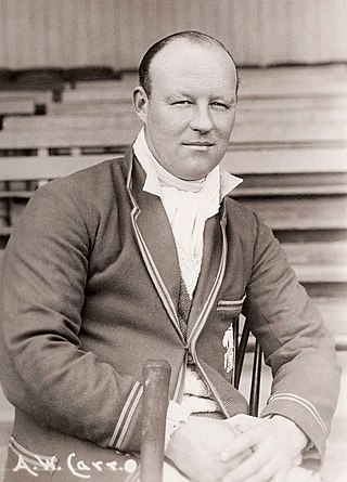
Arthur William Carr was an English cricketer. He played for the Nottinghamshire County Cricket Club and the English cricket team, captaining both sides.
Dalhousie was a Canadian town located in Restigouche County, New Brunswick. New Brunswick's northernmost point of land is situated in Dalhousie, where the Restigouche River meets Chaleur Bay. The town has a population of 3,126 (2016).

Dalhousie Springs, also known as Witjira-Dalhousie Springs, is a group of over 60 natural artesian springs located in Witjira National Park on the western fringe of the Simpson Desert, 180 kilometres northeast of Oodnadatta in northern South Australia. They are about 250 kilometres (160 mi) southeast of Alice Springs.

Lands administrative divisions of Australia are the cadastral divisions of Australia for the purposes of identification of land to ensure security of land ownership. Most states term these divisions as counties, parishes, hundreds, and other terms. The eastern states of Queensland, New South Wales, Victoria, and Tasmania were divided into counties and parishes in the 19th century, although the Tasmanian counties were renamed land districts in the 20th century. Parts of South Australia (south-east) and Western Australia (south-west) were similarly divided into counties, and there were also five counties in a small part of the Northern Territory. However South Australia has subdivisions of hundreds instead of parishes, along with the Northern Territory, which was part of South Australia when the hundreds were proclaimed. There were also formerly hundreds in Tasmania. There have been at least 600 counties, 544 hundreds and at least 15,692 parishes in Australia, but there are none of these units for most of the sparsely inhabited central and western parts of the country.

Yongala is a small town located in the state of South Australia, Australia. It has a population of approximately 240 people and is situated on the Clare-Peterborough Road (B79), 238 km from Adelaide, the state capital.

Curramulka is a town in the Australian state of South Australia on the Yorke Peninsula. Curramulka is within easy driving distance of the coastal resort towns of Port Victoria and Port Vincent and is 15 kilometres (9.3 mi) north-east of Minlaton. At the 2016 census, Curramulka had a population of 305.
Nangwarry is a town and a locality in the Australian state of South Australia located about 352 kilometres (219 mi) south-east of the state capital of Adelaide and about 32 kilometres (20 mi) north-west of the regional centre of Mount Gambier.

The phrase pray and work refers to the Catholic monastic practice of working and praying, generally associated with its use in the Rule of Saint Benedict.

The County of Dalhousie is one of the 49 cadastral counties of South Australia in straddling the Mid North and Flinders Ranges regions. It was proclaimed in 1871 by Governor James Fergusson and was named for Fergusson's father-in-law James Broun-Ramsay, 1st Marquess of Dalhousie.

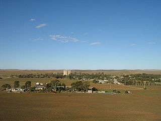
The Hundred of Yongala is a cadastral unit of hundred located in the Mid North of South Australia. It is one of the 12 hundreds of the County of Dalhousie and was proclaimed by Governor James Fergusson in 1871. The eponymous township of Yongala lies in the west of the hundred and the larger township of Peterborough in the north east. The locality of Sunnybrae occupies the remainder of the hundred.

The Hundred of Tarcowie is a cadastral unit of hundred located on the south western slopes of the Narien Range in the Mid North of South Australia spanning the township of Tarcowie, the locality of Hornsdale, and surrounds. One of the 12 hundreds of the County of Dalhousie, it was proclaimed in 1871 by Governor James Fergusson and named for an indigenous term thought to mean 'wash away water'.

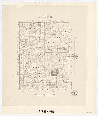
The Hundred of Erskine is a hundred in the County of Dalhousie, South Australia. The hundred was established 1876 but contains no townships.

The Hundred of Morgan is a hundred in the County of Dalhousie, South Australia. The hundred was established 1876 but has no townships.

The Hundred of Yalpara is a hundred in the County of Dalhousie, South Australia. The hundred was established 1876 and a government town called Brassey was laid out, though it never developed into a township. The hundred is largely occupied by the locality of Yalpara but a portion of Minburra crosses the western border.

The County of Albert is one of the 49 cadastral counties of South Australia on the east banks of the River Murray. It was proclaimed by Governor Richard MacDonnell in 1860 and named for Albert, Prince Consort of Queen Victoria.
The Hundred of Yaranyacka is a cadastral hundred in the County of Flinders, South Australia. The Hundred was proclaimed on 20 June 1872 and corrupted from the Aboriginal yakkara meaning 'plain' or 'level country'.

County of Herbert is a cadastral unit located in the Australian state of South Australia that covers land to the east of the Flinders Ranges about 55 kilometres (34 mi) north-east of the town of Peterborough. It was proclaimed in 1877 and named after a prominent man of the time with either a title or a surname containing the name ‘Herbert’. It has been partially divided in the following sub-units of hundreds – Cavenagh, Coglin, Minburra, Nackara, Paratoo and Waroonee.

Johnburgh is a town and a locality in the Australian state of South Australia located on the eastern side of the Flinders Ranges about 275 kilometres (171 mi) north of the state capital of Adelaide and about 32 kilometres (20 mi) north-east of the municipal seat of Orroroo.

County of Kimberley is a cadastral unit located in the Australian state of South Australia that covers land to the east of the Flinders Ranges about 45 kilometres (28 mi) east of the town of Peterborough. It was proclaimed in 1871 and named after John Wodehouse, 1st Earl of Kimberley, a British Secretary of State for the Colonies. It has been partially divided in the following sub-units of hundreds – Gumbowie, Hardy, Ketchowla, Parnaroo, Terowie and Wonna.


