
The Hundred of Robertson is a Hundred of the County of Robe in South Australia. [1] The hundred is located on the Limestone Coast region, south east of the state capital of Adelaide. The Hundred is located inland from the coast.
The Hundred of Robertson is a Hundred of the County of Robe in South Australia. [1] The hundred is located on the Limestone Coast region, south east of the state capital of Adelaide. The Hundred is located inland from the coast.

The Limestone Coast is a name used since the early twenty-first century for a South Australian government region located in the south east of South Australia which immediately adjoins the continental coastline and the Victorian border. The name is also used for a tourist region and a wine zone both located in the same part of South Australia.

Robe is a town and fishing port located in the Limestone Coast of South Australia. The town's distinctive combination of historical buildings, ocean, fishing fleets, lakes and dense bush is widely appreciated. Robe lies on the southern shore of Guichen Bay, just off the Princes Highway. At the 2016 census, Robe had a population of 998. Robe is the main town in the District Council of Robe local government area. It is in the state electorate of MacKillop and the federal Division of Barker.

The District Council of Robe is a local government area located in the Limestone Coast area of South Australia. The main offices are in Robe, the town after which the council is named. The district relies on a mix of agriculture, fisheries and tourism as major components of its economy.
Greenways is a town and a locality in the Australian state of South Australia located in the state's south-east within the Limestone Coast region about 355 kilometres (221 mi) south east of the state capital of Adelaide and about 46 kilometres (29 mi) east of the municipal seat of Robe.
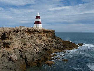
Guichen Bay, is a bay located on the south-east coast of the Australian state of South Australia about 115 kilometres northwest of the regional city of Mount Gambier and about 270 kilometres south-southeast of the state capital of Adelaide. It was named in 1802 by the Baudin expedition of 1800-03 after Luc Urbain de Bouëxic, comte de Guichen. The town of Robe is located at the southern end of the bay.
Bernouilli Conservation Reserve is a protected area located in the Australian state of South Australia in the gazetted locality of Cape Jaffa about 21 kilometres south west of the township of Kingston SE in the state's Limestone Coast region. The conservation reserve was proclaimed under the Crown Lands Act 1929 on 11 November 1993. The name is derived from Cap Bernouilli, the former name of the headland of Cape Jaffa. The conservation reserve is classified as an IUCN Category VI protected area.

Limestone Coast zone is a wine zone located in the south east of South Australia. It extends south of a line of latitude approximately in line with Cape Willoughby at the east end of Kangaroo Island and it is bounded by the continental coastline and the border with Victoria. It consists of the following wine regions all of which have received appellation as an Australian Geographical Indication (AGI): Coonawarra, Mount Benson, Mount Gambier, Robe, Padthaway, Wrattonbully and a small number of vineyards located outside the above regions. The zone received AGI in 1996.
Robe is a wine region located in the south east of South Australia immediately adjoining the town of Robe. The region received appellation as an Australian Geographical Indication (AGI) in 2006. It is part of the Limestone Coast wine zone.

The County of Robe is one of the 49 cadastral counties of South Australia. It was proclaimed by and named for Governor Frederick Robe in 1846. It covers a portion of the state's south-east from the west coast at Robe to the border with Victoria on the east. This includes the following contemporary local government areas of the state:
Nora Creina is a locality in the Australian state of South Australia located on the state’s south-east coast overlooking the Southern Ocean. It is about 99 kilometres to the north-west of the city of Mount Gambier and about 290 kilometres south-east of the state capital of Adelaide.

The Hundred of Kadina is a cadastral unit of hundred located on the north-western Yorke Peninsula in South Australia. It is one of the 16 hundreds of the County of Daly and was proclaimed by Governor Dominick Daly on 12 June 1862.
The Hundred of Waterhouse is a cadastral hundred of the County of Robe, South Australia, established in 1846.
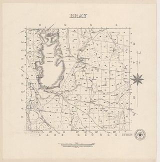
The Hundred of Bray, is a hundred in the County of Robe within the Limestone Coast region of South Australia.
Bray is a locality in South Australia, roughly contiguous with the land administration division, the Hundred of Bray, after which it was named. It is located within the federal division of Barker, the state electoral district of MacKillop and the local government areas of the District Council of Robe and the Wattle Range Council.

The Hundred of Killanoola is a hundred in the County of Robe in the Limestone Coast region of South Australia.

The Hundred of Smith is a hundred in the County of Robe, in the Limestone Coast region of South Australia.
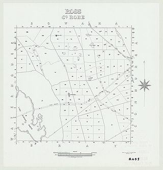
The Hundred of Ross, is a hundred in the County of Robe in the Limestone Coast region of South Australia.

The Hundred of Bowaka, is a hundred in the County of Robe, within the Limestone Coast region of South Australia. The hundred is located at 36°55′38″S 140°1′33″E.

The Hundred of Mount Benson, is a hundred in the County of Robe, within the Limestone Coast region of South Australia.
Boatswain Point is a locality in the Australian state of South Australia located on the state’s south-east coast overlooking both Guichen Bay and the body of water known in Australia as the Southern Ocean and by international authorities as the Great Australian Bight about 260 kilometres (160 mi) south east of the state capital of Adelaide and about 11 kilometres (6.8 mi) north of the municipal seat of Robe.
| | This South Australia geography article is a stub. You can help Wikipedia by expanding it. |