
Broadcast News is a 1987 American romantic comedy-drama film written, produced and directed by James L. Brooks. The film concerns a virtuoso television news producer who has daily emotional breakdowns, a brilliant yet prickly reporter, and the latter's charismatic but far less seasoned rival. It also stars Robert Prosky, Lois Chiles, Joan Cusack, and Jack Nicholson.

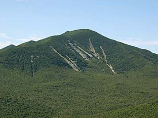
Hunter Mountain is in the towns of Hunter and Lexington, just south of the village of Hunter, in Greene County, New York, United States. At approximately 4,040 feet (1,231 m) in elevation, it is the highest peak in the county and the second-highest peak in the Catskill Mountains.
Dix Mountain is a mountain in the Dix Range of the Adirondacks in the U.S. state of New York. With an elevation of 4,857 feet (1,480 m), it is the sixth-highest peak in New York and one of the 46 Adirondack High Peaks. It is located roughly on the boundary between the towns of North Hudson and Keene in Essex County, and in the High Peaks Wilderness Area of Adirondack Park. The crest of the peak consists of a very narrow ridge, which continues to the southeast and rises to a subsidiary peak named Beckhorn, then continues south to other peaks of the Dix Range. The summit is also in an alpine zone above the treeline. The ridge offers unobstructed views of Elk Lake to the southwest, the Great Range to the northwest, and Lake Champlain and the Green Mountains to the east.

The Johns River, in northern New Hampshire, arises at Cherry Pond in Jefferson and runs approximately 14 miles (23 km), generally northwest, to the Connecticut River. It passes through Hazens Pond, near the Mount Washington Regional Airport, traverses the town of Whitefield, where it is crossed by U.S. Route 3, and then crosses the town of Dalton before joining the Connecticut. It is named for an early hunter and trapper of the area, John Glines, who established a fishing and hunting camp in the area in the 18th century. Another nearby river, the Israel River, is named for John's brother Israel.

The Devil's Path is a hiking trail in the Greene County section of the Catskill Mountains of New York, sometimes described as one of the more challenging trails in the New York Tri-state area. It goes across the eponymous mountain range and then three other peaks to the west, offering hikers and peakbaggers a chance to reach the summits of five of the 35 Catskill High Peaks. It draws hikers from not just the region but far outside, due to the challenging climbs straight up and down the steep gaps between the four peaks of the range, which often require hikers to use hands as well as feet to pull themselves almost straight up cliffs and through rocky chutes. These climbs, however, lead to views across the Catskill range.

Rusk Mountain is a peak located in the towns of Jewett and Lexington in Greene County, New York, United States. At 3,680 feet (1,120 m) in elevation, it is the 20th-highest peak in the Catskill Mountains and considered a member of the Catskill High Peaks. While there is no maintained trail, a bushwhack to the summit is considered relatively easy, and required for membership in the Catskill Mountain 3500 Club.

Macomb Mountain is a mountain in the Dix Range of the Adirondacks in the U.S. state of New York. It is the 21st-highest of the Adirondack High Peaks, with an elevation of 4,405 feet (1,343 m), and the most southeasterly of the High Peaks. It is located in the town of North Hudson in Essex County. The mountain is named for Alexander Macomb, an American general who became famous for his victory at the Battle of Plattsburgh in 1814. The name first appeared in print in 1842. The earliest recorded ascent of the mountain was made in 1872 by guide Mel Trumbull and artist Arthur H. Wyant. Major slides on the western face of the mountain were caused by hurricanes in 1947 and 1950 and expanded by Hurricane Irene in 2011.

Southwest Hunter Mountain (Leavitt Peak) is a subpeak of Hunter Mountain, located in Greene County, New York. It is considered one of the Catskills' High Peaks in its own right, because of its separation from the main summit, and its topographic prominence. Hunter Mountain is named after John Hunter, who also gave his name to the town of Hunter.
North Dome is a mountain located in Greene County, New York. The mountain is part of the Catskill Mountains. North Dome is flanked to the east by West Kill Mountain, and to the west faces Mount Sherrill.
Blackwater Creek, a perennial stream of the Hunter River catchment, is located in the Hunter region of New South Wales, Australia.
Cattle Creek, a partly perennial stream of the Hunter River catchment, is located in the Hunter region of New South Wales, Australia.
Moonan Brook, a mostly perennial stream of the Hunter River catchment, is located in the Hunter region of New South Wales, Australia.
Rouchel Brook, a perennial stream of the Hunter River catchment, is located in the Hunter region of New South Wales, Australia.
Stewarts Brook, a perennial stream of the Hunter River catchment, is located in the Hunter region of New South Wales, Australia.
Widden Brook, a partly perennial stream of the Hunter River catchment, is located in the Hunter region of New South Wales, Australia.

The West Kill, an 11-mile-long (18 km) tributary of Schoharie Creek, flows through the town of Lexington, New York, United States, from its source on Hunter Mountain, the second-highest peak of the Catskill Mountains. Ultimately its waters reach the Hudson River via the Mohawk. Since it drains into the Schoharie upstream of Schoharie Reservoir, it is part of the New York City water supply system. It lends its name to both a mountain to its south and a small town midway along its length.
Hagadone Brook converges with West Kill west of Spruceton, New York. Hagadone Brook drains the northern slopes of North Dome.
Herdman Brook converges with West Kill by Spruceton, New York.

Diamond Notch Falls is a waterfall located on the West Kill, east of Spruceton in the Hunter-West Kill Wilderness in Greene County, New York. Diamond Notch Falls is a side by side waterfall, both being about 15 feet (4.6 m) in height.
Evergreen Mountain is a mountain located in Greene County, New York north of Spruceton, New York. Herdman Brook drains the southeastern portion of the mountain and flows south before converging with West Kill. West Kill flows westwards, south of Evergreen Mountain and the Schoharie Creek flows eastwards, north of the mountain.
