"},"population_total":{"wt":"770"},"population_density_km2":{"wt":"auto"},"population_density_sq_mi":{"wt":"auto\n\n"},"timezone":{"wt":"[[North American Eastern Time Zone|Eastern (EST)]]"},"utc_offset":{"wt":"-5"},"timezone_DST":{"wt":"EDT"},"utc_offset_DST":{"wt":"-4"},"elevation_footnotes":{"wt":""},"elevation_m":{"wt":"488"},"elevation_ft":{"wt":"1601"},"coordinates":{"wt":"{{coord|42|12|54|N|74|23|5|W|region:US-NY|display=inline}}"},"postal_code_type":{"wt":"[[ZIP code]]"},"postal_code":{"wt":"12452"},"area_code":{"wt":"[[Area code 518|518]]"},"blank_name":{"wt":"[[Federal Information Processing Standards|FIPS code]]"},"blank_info":{"wt":"36-039-42202"},"blank1_name":{"wt":"[[Geographic Names Information System|GNIS]] feature ID"},"blank1_info":{"wt":"0979147"},"website":{"wt":""},"footnotes":{"wt":""},"pop_est_as_of":{"wt":""},"pop_est_footnotes":{"wt":""},"population_est":{"wt":""}},"i":0}}]}" id="mwBw">Town in New York, United States
Lexington, New York | |
---|---|
![]() Location in Greene County and the state of New York | |
Coordinates: 42°12′54″N74°23′5″W / 42.21500°N 74.38472°W | |
Country | United States |
State | New York |
County | Greene |
Government | |
• Type | Town Council |
• Town Supervisor | JoEllen Schermerhorn (D) |
• Town Council | Members' List |
Area | |
• Total | 80.25 sq mi (207.85 km2) |
• Land | 80.21 sq mi (207.75 km2) |
• Water | 0.04 sq mi (0.10 km2) |
Elevation | 1,601 ft (488 m) |
Population | |
• Total | 770 |
• Density | 9.6/sq mi (3.7/km2) |
Time zone | UTC-5 (Eastern (EST)) |
• Summer (DST) | UTC-4 (EDT) |
ZIP code | 12452 |
Area code | 518 |
FIPS code | 36-039-42202 |
GNIS feature ID | 0979147 |
Lexington is a town in Greene County, New York, United States. The population was 770 at the 2020 census. [2] [ better source needed ] The town is in the southwestern part of Greene County.
The area was first settled circa 1788. The town of Lexington was established in 1813, as the "Town of New Goshen", from the town of Windham. Within a few months, the name was altered to "Lexington".
In 1976, playwright Oakley Hall III co-founded Lexington Conservatory Theatre at historic Lexington House. [3] [4] The company performed there for five years before moving to Albany, NY to become Capital Repertory Theatre. Lexington House was later used as a summer retreat by Ensemble Studio Theatre. The location was also featured in the 2004 documentary The Loss of Nameless Things . [5]
In 2024, the town of Lexington applied for funding from the New York State Restore NY program, on behalf of a group of projects designed to revitalize the Lexington hamlet and restore and re-use several nearby historic structures. The proposal includes the restoration of Lexington House and the adjacent Barn Theatre, which previously housed Lexington Conservatory and Ensemble Studio Theatre. [6]
According to the United States Census Bureau, the town has a total area of 79.7 square miles (206 km2), of which 79.7 square miles (206 km2) is land and 0.04 square miles (0.10 km2), or 0.04%, is water. [7]
Lexington is within the Catskill Mountains; most of the town is also inside the Catskill Park Blue Line. The southern town line is the border of Ulster County.
Schoharie Creek flows through the town. The West Kill, an 11-mile-long (18 km) tributary of the Schoharie, drains much of the town.
The summit of West Kill Mountain, sixth-highest peak in the Catskills at approximately 3,880 feet (1,180 m), is the highest point in the town. Three other Catskill High Peaks—Rusk, North Dome and Sherrill—are also within Lexington.
Census | Pop. | Note | %± |
---|---|---|---|
1820 | 1,798 | — | |
1830 | 2,548 | 41.7% | |
1840 | 2,813 | 10.4% | |
1850 | 2,263 | −19.6% | |
1860 | 1,657 | −26.8% | |
1870 | 1,371 | −17.3% | |
1880 | 1,356 | −1.1% | |
1890 | 1,229 | −9.4% | |
1900 | 1,153 | −6.2% | |
1910 | 1,054 | −8.6% | |
1920 | 1,075 | 2.0% | |
1930 | 815 | −24.2% | |
1940 | 827 | 1.5% | |
1950 | 833 | 0.7% | |
1960 | 698 | −16.2% | |
1970 | 666 | −4.6% | |
1980 | 819 | 23.0% | |
1990 | 835 | 2.0% | |
2000 | 830 | −0.6% | |
2010 | 805 | −3.0% | |
2020 | 770 | −4.3% | |
U.S. Decennial Census [8] [ failed verification ] 2020 [2] |
![]() | This section needs to be updated. The reason given is: Newer information is available from the 2010 and 2020 census reports.(November 2022) |
As of the census [9] of 2000, there were 830 people, 375 households, and 219 families residing in the town. The population density was 10.4 inhabitants per square mile (4.0/km2). There were 854 housing units at an average density of 10.7 per square mile (4.1/km2). The racial makeup of the town was 97.35% White, 0.96% Native American, 0.60% Asian, 0.36% from other races, and 0.72% from two or more races. Hispanic or Latino of any race were 1.69% of the population.
There were 375 households, out of which 21.9% had children under the age of 18 living with them, 48.3% were married couples living together, 6.7% had a female householder with no husband present, and 41.6% were non-families. 35.5% of all households were made up of individuals, and 16.8% had someone living alone who was 65 years of age or older. The average household size was 2.21 and the average family size was 2.91.
In the town, the population was spread out, with 20.2% under the age of 18, 4.5% from 18 to 24, 22.9% from 25 to 44, 31.2% from 45 to 64, and 21.2% who were 65 years of age or older. The median age was 47 years. For every 100 females, there were 86.5 males. For every 100 females age 18 and over, there were 96.4 males.
The median income for a household in the town was $29,375, and the median income for a family was $39,583. Males had a median income of $26,250 versus $31,000 for females. The per capita income for the town was $20,471. About 9.0% of families and 12.9% of the population were below the poverty line, including 15.7% of those under age 18 and 14.0% of those age 65 or over.
On August 27, 2011, Hurricane Irene (at that point, a tropical storm) inflicted damage to the town. Very heavy rainfall caused the Schoharie Creek to surge higher and cause immense widespread flooding. High wind speeds were also present. A small bridge was destroyed, and numerous houses were also washed away by the creek. Farms near the creek were flooded as well. Flash flooding also was an issue. Certain roads that run through the town were flooded and some were damaged. Many homes in Lexington lost power.
The Federal Emergency Management Agency arrived in Lexington following the storm. People volunteered for cleanup work and many donated food and clothing. Power was eventually restored to all affected areas.
Rensselaerville is a town in Albany County, New York, United States. The population was 1,826 at the 2020 census. The town is named after Stephen Van Rensselaer.
Roxbury is a town in Delaware County, New York, United States. The population was 2,247 at the 2020 census. The town is at the eastern end of the county.
Ashland is a town in Greene County, New York, United States. The population was 682 in the 2020 US census, down from 784 in the 2010 census. Ashland is in the northwestern part of the county.
Halcott is a town in Greene County, New York, United States. The population was 249 in 2020, down from 258 at the 2010 census. The town is in the southwestern corner of the county.
Jefferson Heights is a hamlet and census-designated place (CDP) in Greene County, New York, United States. The population was 1,122 at the 2020 census.
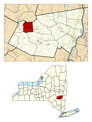
Jewett is a town centrally located in Greene County, New York, United States. The population was 879 at the 2020 census. The town is named for Freeborn G. Jewett, justice of the New York Supreme Court.
Leeds is a hamlet and census-designated place (CDP) in Greene County, New York, United States. The population was 429 at the 2020 census.
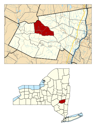
Prattsville is a town in Greene County, New York, United States. The town is in the northwestern part of the county. As of the 2020 census, the population was 774.
Broome is a town in Schoharie County, New York, United States. The population was 863 at the 2020 census. The town is named after John Broome.
Conesville is a town in Schoharie County, New York, United States. The population was 687 at the 2020 census. The town is named after Jonathan Cone, an early resident.
Gilboa is a town in Schoharie County, New York, United States. The population was 1,111 at the 2020 census.
Olive is a town in Ulster County, New York, United States. The town is west of Kingston, New York, and is inside the Catskill Park. The population was 4,226 at the 2020 census.
Shandaken is a town on the northern border of Ulster County, New York, United States, northwest of Kingston, New York. As of the 2020 census, the town had a total population of 2,866. The name is believed to be from an Esopus phrase for "land of rapid waters."
Cairo is a hamlet and census-designated place (CDP) in the town of Cairo in Greene County, New York, United States. The population of the CDP was 1,368 at the 2020 census, out of 6,644 people in the entire town.
Cairo is a town in Greene County, New York, United States. The population was 6,644 at the 2020 census. It is the third largest town in the county. The town is in the southern part of the county, partly in the Catskill Park. The town contains a hamlet, also named Cairo.
Catskill is a town in the southeastern section of Greene County, New York, United States. The population was 11,298 at the 2020 census, the largest town in the county. The western part of the town is in the Catskill Park. The town contains a village, also called Catskill. The village of Catskill has a well-defined Main Street. There is a public boat launch on the Hudson River called Dutchman's Landing.
Hunter is a village in Greene County, New York, United States. The population was 429 at the 2020 census. The village is in the northwestern part of the town of Hunter on New York State Route 23A.
Windham is a hamlet and census-designated place (CDP) in the town of Windham, Greene County, New York, United States. The population of the CDP was 371 at the 2020 census, out of a total of 1,708 people in the town.
Windham is a town in Greene County, New York, United States. The population was 1,708 at the 2020 census. The town was probably named for the town or county of Windham, Connecticut, as many of its earliest settlers came from that state as well as other parts of New England. The town has two nicknames: "Land in the Sky" and "Gem of the Catskills".
Esperance is a town in Schoharie County, New York, United States. The population was 1,806 at the 2020 census. The town was given the name of the principal village, which was named for "hope" in French.