Windham (CDP), New York

Last updated

Windham, New York
USA New York location map.svg
Red pog.svg
Windham
Usa edcp location map.svg
Red pog.svg
Windham
Coordinates: 42°18′42″N74°14′50″W / 42.31167°N 74.24722°W / 42.31167; -74.24722
Country United States
State New York
County Greene
Town Windham
Area
[1]
  Total2.30 sq mi (5.96 km2)
  Land2.30 sq mi (5.96 km2)
  Water0.00 sq mi (0.00 km2)
Elevation
1,516 ft (462 m)
Population
 (2020)
  Total371
  Density161.23/sq mi (62.25/km2)
Time zone UTC-5 (Eastern (EST))
  Summer (DST) UTC-4 (EDT)
ZIP code
12496
Area code 518
FIPS code 36-82469 [2]
GNIS feature ID0971463 [3]
Website www.townofwindhamny.com

Windham is a hamlet and census-designated place (CDP) in the town of Windham, Greene County, New York, United States. The population of the CDP was 367 at the 2010 census, [4] out of a total of 1,703 people in the town.

Contents

The community of Windham is in the western part of the town, on Route 23. It was formerly known by several other names, including "Batavia", "Osbornville", and "Windham Center".

Geography

Windham is located at 42°18′41″N74°14′49″W / 42.31139°N 74.24694°W / 42.31139; -74.24694 (42.311591, -74.247116), [5] in the valley of the Batavia Kill, a westward-flowing tributary of Schoharie Creek and part of the Mohawk River watershed. The hamlet is at the northern boundary of the Catskill Park.

According to the United States Census Bureau, the Windham CDP has a total area of 1.9 square miles (4.9 km2), all land. [4]

Demographics

Historical population
CensusPop.Note
2020 371
U.S. Decennial Census [6]

As of the census [2] of 2000, there were 359 people, 172 households, and 97 families residing in the CDP. The population density was 191.4 inhabitants per square mile (73.9/km2). There were 422 housing units at an average density of 225.0 per square mile (86.9/km2). The racial makeup of the CDP was 98.61% White and 1.39% Native American. Hispanic or Latino of any race were 1.11% of the population.

There were 172 households, out of which 22.7% had children under the age of 18 living with them, 44.8% were married couples living together, 8.1% had a female householder with no husband present, and 43.6% were non-families. 41.3% of all households were made up of individuals, and 19.2% had someone living alone who was 65 years of age or older. The average household size was 2.09 and the average family size was 2.81.

In the CDP, the population was spread out, with 19.5% under the age of 18, 4.7% from 18 to 24, 23.4% from 25 to 44, 24.0% from 45 to 64, and 28.4% who were 65 years of age or older. The median age was 47 years. For every 100 females, there were 100.6 males. For every 100 females age 18 and over, there were 102.1 males.

The median income for a household in the CDP was $32,083, and the median income for a family was $44,250. Males had a median income of $35,625 versus $40,313 for females. The per capita income for the CDP was $23,320. About 6.1% of families and 10.5% of the population were below the poverty line, including 11.1% of those under age 18 and 13.6% of those age 65 or over.

Related Research Articles

<span class="mw-page-title-main">Quinebaug, Connecticut</span> Census-designated place in Connecticut, United States

Quinebaug is a village and census-designated place (CDP) in Thompson, a town in Windham County, Connecticut, United States. The population was 1,133 at the 2010 census.

<span class="mw-page-title-main">South Windham, Connecticut</span> Village in Connecticut, United States

South Windham is a village and census-designated place (CDP) in Windham County, Connecticut, United States. It is located within the town of Windham, Connecticut. The population was 1,421 at the 2010 census.

<span class="mw-page-title-main">Arlington, Illinois</span> Village in Illinois, United States

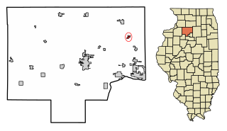
Arlington is a village in Bureau County, Illinois, United States. The population was 169 at the 2020 census. It is part of the Ottawa Micropolitan Statistical Area, located east of the Quad Cities, north of Peoria and Galesburg, west of LaSalle and Peru, and southwest of Rockford and Chicago.

Little Falls-South Windham was a census-designated place (CDP) in Cumberland County, Maine, United States defined for the 2000 census. The population of the CDP was 1,792 at the time. Because of new CDP guidelines for 2010, the CDP has been split into two CDPs: Little Falls and South Windham.

<span class="mw-page-title-main">North Windham, Maine</span> Census-designated place in Maine, United States

North Windham is a census-designated place (CDP) within the town of Windham in Cumberland County, Maine, United States. The population was 4,904 at the 2010 census. It is part of the Portland–South Portland–Biddeford, Maine Metropolitan Statistical Area.

<span class="mw-page-title-main">Putnam (CDP), Connecticut</span> Census-designated place in Connecticut, United States

Putnam District is a village and census-designated place (CDP) in Windham County, Connecticut, United States. The CDP was formed when the former city of Putnam disincorporated, and it consists of the main town center of the town of Putnam along the Quinebaug River. The population was 7,214 at the 2010 census.

<span class="mw-page-title-main">Preston-Potter Hollow, New York</span> Census-designated place in New York, United States

Preston-Potter Hollow is a census-designated place (CDP) in Albany County, New York, United States. The population was 366 at the 2010 census.

<span class="mw-page-title-main">Ashland, Greene County, New York</span> Town in New York, United States

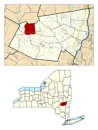
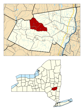
Ashland is a town in Greene County, New York, United States. The population was 682 in the 2020 US census, down from 784 in the 2010 census. Ashland is in the northwestern part of the county.

<span class="mw-page-title-main">Mount Ivy, New York</span> Census-designated place in New York, United States

Mount Ivy is a hamlet and census-designated place in the Town of Haverstraw, in Rockland County, New York, United States. It is located north of New City, east of Pomona, south of Thiells, and west of Garnerville. The population was 6,878 at the 2010 census.

<span class="mw-page-title-main">Quiogue, New York</span> Hamlet and census-designated place in New York, United States

Quiogue is a hamlet and census-designated place (CDP) in the Town of Southampton, in Suffolk County, New York, United States. The population was 816 at the 2010 census. The name of the CDP was corrected from "Quioque" to "Quiogue" by the U.S. Census Bureau in 2010.

<span class="mw-page-title-main">South Hill, New York</span> CDP in New York, United States

South Hill is a census-designated place (CDP) in Tompkins County, New York, United States. The population was 7,245 at the 2020 census.

<span class="mw-page-title-main">West Hurley, New York</span> CDP in New York, United States

West Hurley is a hamlet in Ulster County, New York, United States. The population was 1,917 at the 2020 census.

Limestone is a census-designated place (CDP) in Rogers County, Oklahoma, United States, at an elevation of 705 feet. It is located less than 10 miles west of Claremore, Oklahoma on Oklahoma State Highway 20. The population was 753 as of July 2020.

<span class="mw-page-title-main">Butteville, Oregon</span> Unincorporated community in the state of Oregon, United States

Butteville is a census-designated place and unincorporated community in Marion County, Oregon, United States. For statistical purposes, the United States Census Bureau has defined Butteville as a census-designated place (CDP). The census definition of the area may not precisely correspond to local understanding of the area with the same name. As of the 2020 census the population was 273. It is part of the Salem Metropolitan Statistical Area.

<span class="mw-page-title-main">Blackhawk, South Dakota</span> CDP in South Dakota, United States

Black Hawk is an unincorporated census-designated place (CDP) in Meade County, South Dakota, United States. The population was 3,026 at the 2020 census. Black Hawk has been assigned the ZIP code of 57718. Located along Interstate 90, Black Hawk is part of the Rapid City metropolitan area.

<span class="mw-page-title-main">Riverton-Boulevard Park, Washington</span> Former CDP in Washington, United States

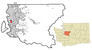
Riverton-Boulevard Park is a former census-designated place (CDP) in King County, Washington, United States. The population was 11,188 at the 2000 census. For the 2010 census, the CDP was separated into the Riverton and Boulevard Park CDPs, with part of the area now being in the city of Tukwila.

Cairo is a hamlet and census-designated place (CDP) in the town of Cairo in Greene County, New York, United States. The population of the CDP was 1,402 at the 2010 census, out of 6,610 people in the entire town.

<span class="mw-page-title-main">Windham (town), New York</span> Town in New York, United States

Windham is a town in Greene County, New York, United States. The population was 1,708 at the 2020 census. The town was probably named for the town or county of Windham, Connecticut, as many of its earliest settlers came from that state as well as other parts of New England. The town has two nicknames: "Land in the Sky" and "Gem of the Catskills".

<span class="mw-page-title-main">Brattleboro (CDP), Vermont</span> CDP in Vermont, United States

Brattleboro is a census-designated place (CDP) corresponding to the densely populated core of the town of Brattleboro in Windham County, Vermont, United States. The population was 8,289 at the 2000 census.

<span class="mw-page-title-main">Woodstock (CDP), New York</span> CDP in New York, United States

Woodstock is a hamlet in Ulster County, New York, United States. The population was 2,088 according to the 2010 census. The community of Woodstock is in the eastern part of the Town of Woodstock and is northwest of Kingston. It is located along NY 212 near its junction with NY 375. Although the name of the community and the town lent its name to the Woodstock Festival, that event did not take place in Woodstock.

References

  1. "ArcGIS REST Services Directory". United States Census Bureau. Retrieved September 20, 2022.
  2. 1 2 "U.S. Census website". United States Census Bureau . Retrieved January 31, 2008.
  3. "US Board on Geographic Names". United States Geological Survey. October 25, 2007. Retrieved January 31, 2008.
  4. 1 2 "Geographic Identifiers: 2010 Demographic Profile Data (G001): Windham CDP, New York". American Factfinder. U.S. Census Bureau. Retrieved December 29, 2016.[ dead link ]
  5. "US Gazetteer files: 2010, 2000, and 1990". United States Census Bureau. February 12, 2011. Retrieved April 23, 2011.
  6. "Census of Population and Housing". Census.gov. Retrieved June 4, 2016.