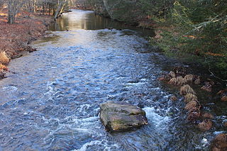
Huntington Creek (Utah)

Last updated
Huntington Creek
Autumn colours in SW Utah - spectacular colours along Huntington Creek on Hwy 31, Utah (15630237506).jpg
Fall colors along Huntington Creek,
October 2014
Country United States
State Utah
County Emery County
Physical characteristics
Main source Emery County
39°38′34″N111°14′09″W / 39.642741°N 111.2357298°W / 39.642741; -111.2357298
River mouth Castle Valley (Carbon, Emery, and Sevier counties, Utah)
5,344 feet (1,629 m)
39°08′57″N110°54′47″W / 39.1491394°N 110.9129440°W / 39.1491394; -110.9129440 Coordinates: 39°08′57″N110°54′47″W / 39.1491394°N 110.9129440°W / 39.1491394; -110.9129440
Basin features
Progression San Rafael River

Huntington Creek is a tributary of the San Rafael River in northwestern Emery County, Utah, United States. [1] It rises in the Electric Lake on the Wasatch Plateau in the Manti-La Sal National Forest, and flows down to the floor of Castle Valley in Emery County. Electric Lake, created in 1974, regulates its flow to supply water to the Huntington Power Plant at the bottom of the canyon. The creek is an important fishery. [2]

San Rafael River river in Emery and Grand counties in Utah, United States

The San Rafael River is a tributary of the Green River, approximately 90 miles (140 km) long, in east central Utah, United States. The river flows across a sparsely populated arid region of the Colorado Plateau, and is known for the isolated, scenic gorge through which it flows.

Emery County, Utah County in the United States

Emery County is a county in east-central Utah, United States. As of the 2010 United States Census, the population was 10,976. Its county seat is Castle Dale, and the largest city is Huntington.
Utah A state of the United States of America

Utah is a state in the western United States. It became the 45th state admitted to the U.S. on January 4, 1896. Utah is the 13th-largest by area, 31st-most-populous, and 10th-least-densely populated of the 50 United States. Utah has a population of more than 3 million according to the Census estimate for July 1, 2016. Urban development is mostly concentrated in two areas: the Wasatch Front in the north-central part of the state, which contains approximately 2.5 million people; and Washington County in Southern Utah, with over 160,000 residents. Utah is bordered by Colorado to the east, Wyoming to the northeast, Idaho to the north, Arizona to the south, and Nevada to the west. It also touches a corner of New Mexico in the southeast.
Contents

See also

Related Research Articles

Carbon County, Utah County in the United States

Carbon County is a county in the U.S. state of Utah. As of the 2010 United States Census, the population was 21,403. Its county seat and largest city is Price.

Sanpete County, Utah County in the United States

Sanpete County is a county in the U.S. state of Utah. As of the 2010 United States Census, the population was 27,822. Its county seat is Manti, and its largest city is Ephraim. The county was created in 1850.

Sevier County, Utah County in the United States

Sevier County is a county in Utah, United States. As of the 2010 United States Census, the population was 20,802. Its county seat and largest city is Richfield.

Huntington, Utah City in Utah, United States

Huntington is a city in northwestern Emery County, Utah, United States. The population was 2,129 at the 2010 census. It is the largest town in Emery County.

Willow Creek may refer to:

Muddy Creek (central Utah)

Muddy Creek is a stream in central Utah, United States, that drains portions of Emery, Sanpete, Sevier, and Wayne counties.

Huntington Creek (Pennsylvania) tributary of Fishing Creek (North Branch Susquehanna River) in Luzerne and Columbia counties, Pennsylvania

Huntington Creek is a tributary of Fishing Creek in Luzerne and Columbia counties, Pennsylvania, in the United States. It is approximately 29.5 miles (47.5 km) long.

State Route 31 (SR-31) is a state highway in Sanpete and Emery Counties in the U.S. state of Utah. It runs for 47.746 miles (76.840 km) from US-89 at Fairview to SR-10 in Huntington. The highway has been designated as part of The Energy Loop, a National Scenic Byway.


The Central Utah Project is a US federal water project that was authorized for construction under the Colorado River Storage Project Act of April 11, 1956, as a participating project. In general, the Central Utah Project develops a portion of Utah's share of the yield of the Colorado River, as set out in the Colorado River Compact of 1922.

State Route 264 is a state highway in central Utah that connects Sanpete County to Carbon County through Flat Canyon, Boulger Canyon, Upper Huntington Canyon, and Eccles Canyon. It is part of The Energy Loop, a National Scenic Byway.

Connellsville, Utah Ghost town in Utah, United States

Connellsville is a ghost town located high in the mountains of Coal Canyon, near the head of Huntington Canyon in the northwestern corner of Emery County, Utah, United States. A coal mining and coke manufacturing center, Connellsville was the first settlement in what is now Emery County, inhabited from 1874 to 1878. The town now lies beneath the waters of Electric Lake.

Huntington Creek may refer to several places:

Moore, Utah Unincorporated community in Utah, United States

Moore is an unincorporated community in west central Emery County, Utah, United States, at the edge of the San Rafael Swell.

Quitchupah Creek river in the United States of America

Quitchupah Creek is a stream draining portions of Emery and Sevier Counties in central Utah, in the western United States. Quitchupah Creek is significant for its rock art remains of the Fremont culture that line its banks. Quitchupah is Ute for "animals fare poorly." The drainage area is located within the Colorado River Basin near the south end of the Wasatch Plateau. All drainage from the area flows to Quitchupah Creek or its tributaries, including East Spring Canyon, Water Hollow, and North Fork and flows through Convulsion Canyon.

Big Cottonwood Creek river in the United States of America

Big Cottonwood Creek is one of the largest streams entering Salt Lake Valley from the east from the Wasatch Mountains. The creek flows through the Big Cottonwood Canyon in a westerly direction until it emerges into Salt Lake Valley about eighteen miles (29 km) from its highest source. Thence its course is northwesterly through Cottonwood Heights, Holladay, and Murray, Utah until it empties into the Jordan River about five miles (8.0 km) south of Salt Lake City. In the summer its waters are all used for irrigation purposes. From its source to its original outlet into the Jordan River is a distance of about twenty six miles.

Huntington State Park

Huntington State Park is a protected area of Utah, United States, featuring a warm-water reservoir. The state park is located near the town of Huntington.

Huntington North Dam

Huntington North Dam is a dam in Emery County, Utah.

References

  1. U.S. Geological Survey Geographic Names Information System: Huntington Creek
  2. "Huntington Creek". wildlife.utah.gov. Utah Division of Wildlife Resources . Retrieved 17 Aug 2018.

Commons-logo.svg Media related to Huntington Creek (Utah) at Wikimedia Commons