Silk is a natural protein fiber, some forms of which can be woven into textiles. The protein fiber of silk is composed mainly of fibroin and is most commonly produced by certain insect larvae to form cocoons. The best-known silk is obtained from the cocoons of the larvae of the mulberry silkworm Bombyx mori reared in captivity (sericulture). The shimmering appearance of silk is due to the triangular prism-like structure of the silk fibre, which allows silk cloth to refract incoming light at different angles, thus producing different colors.

The Silk Road was a network of Eurasian trade routes active from the second century BCE until the mid-15th century. Spanning over 6,400 km (4,000 mi), it played a central role in facilitating economic, cultural, political, and religious interactions between the Eastern and Western worlds. The name "Silk Road" was coined in the late 19th century, but some 20th- and 21st-century historians instead prefer the term Silk Routes, on the grounds that it more accurately describes the intricate web of land and sea routes connecting Central, East, South, Southeast, and West Asia as well as East Africa and Southern Europe.

Sogdia or Sogdiana was an ancient Iranian civilization between the Amu Darya and the Syr Darya, and in present-day Uzbekistan, Turkmenistan, Tajikistan, Kazakhstan, and Kyrgyzstan. Sogdiana was also a province of the Achaemenid Empire, and listed on the Behistun Inscription of Darius the Great. Sogdiana was first conquered by Cyrus the Great, the founder of the Achaemenid Empire, and then was annexed by the Macedonian ruler Alexander the Great in 328 BC. It would continue to change hands under the Seleucid Empire, the Greco-Bactrian Kingdom, the Kushan Empire, the Sasanian Empire, the Hephthalite Empire, the Western Turkic Khaganate and the Muslim conquest of Transoxiana.

Dunhuang is a county-level city in northwestern Gansu Province, Western China. According to the 2010 Chinese census, the city has a population of 186,027, though 2019 estimates put the city's population at about 191,800. Sachu (Dunhuang) was a major stop on the ancient Silk Road and is best known for the nearby Mogao Caves.

The Taklamakan Desert is a desert in northwest China's Xinjiang region. Located inside the Tarim Basin in Southern Xinjiang, it is bounded by the Kunlun Mountains to the south, the Pamir Mountains to the west, the Tian Shan range to the north, and the Gobi Desert to the east.

Kucha or Kuche was an ancient Buddhist kingdom located on the branch of the Silk Road that ran along the northern edge of what is now the Taklamakan Desert in the Tarim Basin and south of the Muzat River.

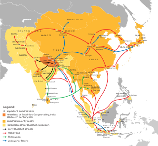
Mahāyāna Buddhism entered Han China via the Silk Road, beginning in the 1st or 2nd century CE. The first documented translation efforts by Buddhist monks in China were in the 2nd century CE via the Kushan Empire into the Chinese territory bordering the Tarim Basin under Kanishka. These contacts transmitted strands of Sarvastivadan and Tamrashatiya Buddhism throughout the Eastern world.

Indian Chinese cuisine, Chinese Indian cuisine, Indo-Chinese cuisine, Sino-Indian cuisine, Chindian cuisine, Hakka Chinese or Desi-Chinese cuisine is a distinct style of Chinese cuisine adapted to Indian tastes, combining Chinese foods with Indian flavours and spices. Though Asian cuisines have mixed throughout history throughout Asia, the most popular origin story of the fusion food resides with Chinese labourers of Calcutta, who immigrated to British India looking for work. Opening restaurant businesses in the area, these early Chinese food sellers adapted their culinary styles to suit Indian tastes.

The Port of Shanghai is located in the vicinity of Shanghai, comprises a deep-sea port and a river port.

Yumen Pass, or Jade Gate or Pass of the Jade Gate, is the name of a pass of the Great Wall located west of Dunhuang in today's Gansu Province of China. During the Han dynasty, this was a pass through which the Silk Road passed, and was the one road connecting Central Asia with East Asia (China), the former called the Western Regions. Just to the south was the Yangguan pass, which was also an important point on the Silk Road. These passes, along with other sites along the Silk Road, were inscribed in 2014 on the UNESCO World Heritage List as the Silk Roads: the Routes Network of Chang'an-Tianshan Corridor World Heritage Site. The pass is at an elevation of 1400 meters.

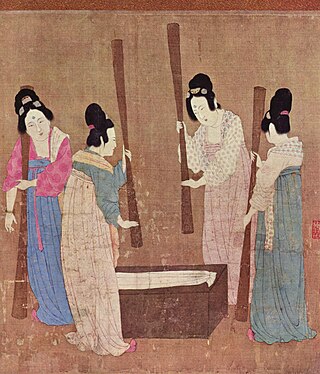
The production of silk originated in Neolithic China within the Yangshao culture. Though it would later reach other places in the world, the art of silk production remained confined to China until the Silk Road opened at 114 BC. Even after trade opened, China maintained a virtual monopoly over silk production for another thousand years. The use of silk within China was not confined to clothing alone, and silk was used for a number of applications, such as writing. Within clothing, the color of silk worn also held social importance, and formed an important guide of social class during the Tang dynasty of China.

Miran or Mirān is a former city that existed until the 1st millennium, on the southern rim of the Taklamakan Desert in Xinjiang, China. Located at an oasis, where the Lop Nur desert meets the Altun Shan mountains, Miran was once a major point on the Silk Road.

The Northern Silk Road is a historic inland trade route in Northwest China and Central Asia, originating in the ancient Chinese capital of Chang'an, westwards through the Hexi Corridor into the Tarim Basin, going around north of the Taklamakan Desert along the two sides of the Tianshan Mountains, and then past the Pamir Mountains to reach the ancient kingdoms of Bactria, Sogdia, Kushan, Parthia and eventually the eastern provinces of the Roman Empire. It is the northernmost branch of the several Silk Roads providing trade, cultural exchanges and military mobilizations between China and the outside world.

China is the world's largest and earliest silk producer. The vast majority of Chinese silk originates from the mulberry silkworms. During the larval stage of its life cycle, the insects feed on the leaves of mulberry trees. Non-mulberry silkworm cocoon production in China primarily focuses on wild silk from the Chinese Tussah moth. This moth typically feeds on trees and its larvae spin coarser, flatter, yellower filament than the mulberry silkworms.

Silk Roads: The Routes Network of Chang'an-Tian Shan Corridor is a UNESCO World Heritage Site which covers the Chang'an-Tianshan portion of the ancient Silk Road and historical sites along the route. On June 22, 2014, UNESCO designated a 5,000 km stretch of the Silk Road network from Central China to the Zhetysu region of Central Asia as a World Heritage site. The corridor spans China, Kazakhstan and Kyrgyzstan and includes 33 new sites and several previously designated heritage sites.

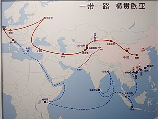
The 21st Century Maritime Silk Road, commonly just Maritime Silk Road (MSR), is the sea route part of the Belt and Road Initiative which is a Chinese strategic initiative to increase investment and foster collaboration across the historic Silk Road.
The Belt and Road Initiative, known in China as the One Belt One Road and sometimes referred to as the New Silk Road, is a global infrastructure development strategy adopted by the Chinese government in 2013 to invest in more than 150 countries and international organizations. The BRI is composed of six urban development land corridors linked by road, rail, energy, and digital infrastructure and the Maritime Silk Road linked by the development of ports.

The Silk Road Fund is a China Government Guidance Fund to foster increased investment in countries along the Belt and Road Initiative, an economic development initiative primarily covering Eurasia. The Chinese government pledged US$40 billion for the creation of the investment fund, established on 29 December 2014.

Beef chow fun, also known as beef ho fun, gōn cháau ngàuh hó, or gānchǎo níuhé in Chinese (乾炒牛河) meaning "dry fried beef Shahe noodles", is a staple Cantonese dish made from stir-frying beef, hor fun and bean sprouts. It is commonly found in yum cha restaurants in Guangdong, Hong Kong, and overseas, as well as in cha chaan tengs. Chow fun, or stir-fried hor fun noodles, is any number of different individual preparations. In the Philippines, it is called "beef hofan".

The Maritime Silk Road or Maritime Silk Route is the maritime section of the historic Silk Road that connected Southeast Asia, East Asia, the Indian subcontinent, the Arabian Peninsula, eastern Africa, and Europe. It began by the 2nd century BCE and flourished until the 15th century CE. The Maritime Silk Road was primarily established and operated by Austronesian sailors in Southeast Asia who sailed large long-distance ocean-going sewn-plank and lashed-lug trade ships. The route was also utilized by the dhows of the Persian and Arab traders in the Arabian Sea and beyond, and the Tamil merchants in South Asia. China also started building their own trade ships (chuán) and followed the routes in the later period, from the 10th to the 15th centuries CE.


