Related Research Articles

The Snowball Earth is a geohistorical hypothesis that proposes during one or more of Earth's icehouse climates, the planet's surface became nearly entirely frozen with no liquid oceanic or surface water exposed to the atmosphere. The most academically mentioned period of such a global ice age is believed to have occurred some time before 650 mya during the Cryogenian period, which included at least two large glacial periods, the Sturtian and Marinoan glaciations.

The Oak Ridges Moraine is an ecologically important geological landform in the Mixedwood Plains of south-central Ontario, Canada. The moraine covers a geographic area of 1,900 square kilometres (730 sq mi) between Caledon and Rice Lake, near Peterborough. One of the most significant landforms in southern Ontario, the moraine gets its name from the rolling hills and river valleys extending 160 km (99 mi) east from the Niagara Escarpment to Rice Lake, formed 12,000 years ago by advancing and retreating glaciers during the last glaciation period. Below the approximately 200 metre thick glacial derived sediments of the moraine lies thick bedrock successions of Precambrian rocks and up to 200 metres of Ordovician aged rock, capped by a regional unconformity of erosion and non-deposition to the Quaternary period. Rivers and lakes scatter the landscape and are important for creating habitat for the rich diversity of species of animals, trees and shrubbery. These are also the supply of fresh water to aquifers in the moraine through complex subterranean connections. Construction development nearby, and with expansion of communities around the moraine in need of potable water, it is a contested site in Ontario, since it stands in the path of major urban development. Conservation of the moraine is thus an important step for keeping aquifers in a safe drinkable condition while also protecting the natural ecosystems surrounding and within the moraine. This region has been subject to multiple decades of scientific research to study the origins of formation, and how early communities used the land. A larger focus currently is how to source potable water without removing the aquifer entirely.

Glacial landforms are landforms created by the action of glaciers. Most of today's glacial landforms were created by the movement of large ice sheets during the Quaternary glaciations. Some areas, like Fennoscandia and the southern Andes, have extensive occurrences of glacial landforms; other areas, such as the Sahara, display rare and very old fossil glacial landforms.

Of the many unconformities (gaps) observed in geological strata, the term Great Unconformity is frequently applied to either the unconformity observed by James Hutton in 1787 at Siccar Point in Scotland, or that observed by John Wesley Powell in the Grand Canyon in 1869. Both instances are exceptional examples of where the contacts between sedimentary strata and either sedimentary or crystalline strata of greatly different ages, origins, and structure represent periods of geologic time sufficiently long to raise great mountains and then erode them away.
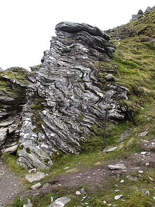
The Huronian glaciation was a period where at least three ice ages occurred during the deposition of the Huronian Supergroup. Deposition of this largely sedimentary succession extended from approximately 2.5 to 2.2 billion years ago (Gya), during the Siderian and Rhyacian periods of the Paleoproterozoic era. Evidence for glaciation is mainly based on the recognition of diamictite, that is interpreted to be of glacial origin. Deposition of the Huronian succession is interpreted to have occurred within a rift basin that evolved into a largely marine passive margin setting. The glacial diamictite deposits within the Huronian are on par in thickness with Quaternary analogs.

Jasper conglomerate is an informal term for a very distinctive Paleoproterozoic quartz and jasper pebble conglomerate that occurs within the middle part of the Lorrain Formation of the Cobalt Group of the Huronian Supergroup. It is also known by other names including pebble jasper conglomerate, St. Joseph Island puddingstone, Drummond Island puddingstone, Michigan puddingstone. The jasper conglomerate occurs on St. Joseph Island and the St. Mary's River area north and northwest of the Bruce Mines of Northern Ontario, about 65 kilometres (40 mi) east of Sault Ste. Marie. This conglomerate consisted originally of gravelly sands and sandy gravels composed of subrounded pebbles of red jasper, white quartzite, semi-transparent quartz, and black chert, with coarse-grained sand matrix. Typically it contains between about 30% to as much as 90% pebbles. It has been cemented and partially metamorphosed into a quartzitic conglomerate. The beds of jasper conglomerates fill erosional troughs and channels of what are interpreted to be either alluvial fan or braided river deposits of the Lorrain Formation. These deposits are interpreted to represent nonglacial deposits that immediately postdate the Makganyene glaciation.
The Dalradian Supergroup is a stratigraphic unit in the lithostratigraphy of the Grampian Highlands of Scotland and in the north and west of Ireland. The diverse assemblage of rocks which constitute the supergroup extend across Scotland from Islay in the west to Fraserburgh in the east and are confined by the Great Glen Fault to the northwest and the Highland Boundary Fault to the southeast. Much of Shetland east of the Walls Boundary Fault is also formed from Dalradian rocks. Dalradian rocks extend across the north of Ireland from County Antrim in the north east to Clifden on the Atlantic coast, although obscured by younger Palaeogene lavas and tuffs or Carboniferous rocks in large sections.

The Karoo Supergroup is the most widespread stratigraphic unit in Africa south of the Kalahari Desert. The supergroup consists of a sequence of units, mostly of nonmarine origin, deposited between the Late Carboniferous and Early Jurassic, a period of about 120 million years.
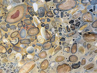
Puddingstone, also known as either pudding stone or plum-pudding stone, is a popular name applied to a conglomerate that consists of distinctly rounded pebbles whose colours contrast sharply with the colour of the finer-grained, often sandy, matrix or cement surrounding them. The rounded pebbles and the sharp contrast in colour gives this type of conglomerate the appearance of a raisin or Christmas pudding. There are different types of puddingstone, with different composition, origin, and geographical distribution. Examples of different types of puddingstones include the Hertfordshire, Schunemunk, Roxbury, and St. Joseph Island puddingstones.
The Great Lakes-St. Lawrence Lowlands, or simply St. Lawrence Lowlands, is a physiographic region of Eastern Canada that comprises a section of southern Ontario bounded on the north by the Canadian Shield and by three of the Great Lakes — Lake Huron, Lake Erie and Lake Ontario — and extends along the St. Lawrence River to the Strait of Belle Isle and the Atlantic Ocean. The lowlands comprise three sub-regions that were created by intrusions from adjacent physiographic regions — the West Lowland, Central Lowland and East Lowland. The West Lowland includes the Niagara Escarpment, extending from the Niagara River to the Bruce Peninsula and Manitoulin Island. The Central Lowland stretches between the Ottawa River and the St. Lawrence River. The East Lowland includes Anticosti Island, Îles de Mingan, and extends to the Strait of Belle Isle.
The Beacon Supergroup is a geological formation exposed in Antarctica and deposited from the Devonian to the Triassic. The unit was originally described as either a formation or sandstone, and upgraded to group and supergroup as time passed. It contains a sandy member known as the Beacon Heights Orthoquartzite.
The Marinoan glaciation, sometimes also known as the Varanger glaciation, was a period of worldwide glaciation. Its beginning is poorly constrained, but occurred no earlier than 654.5 Ma. It ended approximately 632.3 ± 5.9 Ma during the Cryogenian period. This glaciation possibly covered the entire planet, in an event called the Snowball Earth. The end of the glaciation was caused by volcanic release of carbon dioxide and dissolution of gas hydrates and may have been hastened by the release of methane from equatorial permafrost.

The Animikie Group is a geologic group composed of sedimentary and metasedimentary rock, having been originally deposited between 2,500 and 1,800 million years ago during the Paleoproterozoic era, within the Animikie Basin. This group of formations is geographically divided into the Gunflint Range, the Mesabi and Vermilion ranges, and the Cuyuna Range. On the map, the Animikie Group is the dark gray northeast-trending belt which ranges from south-central Minnesota, U.S., up to Thunder Bay, Ontario, Canada. The Gunflint Iron Range is the linear black formation labeled G, the Mesabi Iron Range is the jagged black linear formation labeled F, and Cuyuna Iron Range is the two black spots labeled E. The gabbro of the Duluth Complex, intruded during the formation of the Midcontinent Rift, separates the Mesabi and Gunflint iron ranges; it is shown by the speckled area wrapping around the western end of Lake Superior.
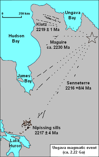
The Nipissing sills, also called the Nipissing diabase, is a large 2217– to 2210–million year old group of sills in the Superior craton of the Canadian Shield in Ontario, Canada, which intrude the Huronian Supergroup. Nipissing sills intrude all the Huronian sediments and older basement rocks in the northern margin of the Sudbury Basin; they were emplaced after the faulting and folding of Huronian rocks, and are hornblende gabbro of tholeiitic basalt composition. In the Sudbury–Elliot Lake area the Nipissing diabase is deformed; outcrops are parallel to the fold axes of the Huronian sedimentary rocks. Nipissing diabase intrusions are east-northeast trending and are no wider than 460 m (1,510 ft).

The Dwyka Group is one of four geological groups that compose the Karoo Supergroup. It is the lowermost geological group and heralds the commencement of sedimentation of the Karoo Supergroup. Based on stratigraphic position, lithostratigraphic correlation and palynological analyses, these lowermost Karoo strata range between the Late Carboniferous (Pennsylvanian) to Early Permian in age.

The Lufilian Arc is part of a system of orogenic belts in southern Africa formed during the Pan-African orogeny, a stage in the formation of the Gondwana supercontinent. It extends across eastern Angola, the Katanga Province of the southern Democratic Republic of the Congo and the northwest of Zambia. The arc is about 800 kilometres (500 mi) long. It has global economic importance owing to its rich deposits of copper and cobalt.
The Sturtian glaciation was a worldwide glaciation during the Cryogenian Period when the Earth experienced repeated large-scale glaciations. As of January 2023, the Sturtian glaciation is thought to have lasted from c. 717 Ma to c. 660 Ma, a time span of approximately 57 million years. It is hypothesised to have been a Snowball Earth event, or contrastingly multiple regional glaciations, and is the longest and most severe known glacial event preserved in the geologic record after the much earlier Huronian glaciation.

The geology of Ontario is the study of rock formations in the most populated province in Canada- it is home to some of the oldest rock on Earth. The geology in Ontario consists of ancient Precambrian igneous and metamorphic rock which sits under younger, sedimentary rocks and soils.
The geology of Mozambique is primarily extremely old Precambrian metamorphic and igneous crystalline basement rock, formed in the Archean and Proterozoic, in some cases more than two billion years ago. Mozambique contains greenstone belts and spans the Zimbabwe Craton, a section of ancient stable crust. The region was impacted by major tectonic events, such as the mountain building Irumide orogeny, Pan-African orogeny and the Snowball Earth glaciation. Large basins that formed in the last half-billion years have filled with extensive continental and marine sedimentary rocks, including rocks of the extensive Karoo Supergroup which exist across Southern Africa. In some cases these units are capped by volcanic rocks. As a result of its complex and ancient geology, Mozambique has deposits of iron, coal, gold, mineral sands, bauxite, copper and other natural resources.

The geological history of Zambia begins in the Proterozoic eon of the Precambrian. The igneous and metamorphic basement rocks tend to be highly metamorphosed and may have formed earlier in the Archean, but heat and pressure has destroyed evidence of earlier conditions. Major sedimentary and metamorphic groups formed in the mid-Proterozoic, followed by a series of glaciations in the Neoproterozoic and much of the Paleozoic which deposited glacial conglomerate as well as other sediments to form the Katanga Supergroup and rift-related Karoo Supergroup. Basalt eruptions blanketed the Karoo Supergroup in the Mesozoic and Zambia shifted to coal and sandstone formation. Geologically recent windblown sands from the Kalahari Desert and alluvial deposits near rivers play an important role in the modern surficial geology of Zambia. The country has extensive natural resources, particularly copper, but also cobalt, emeralds, other gemstones, uranium and coal.
References
- ↑ "Summary of Huronian Stratigraphy". Archived from the original on 2006-10-02. Retrieved 2010-08-18.
- ↑ "Preliminary Redefinition of the Cobalt Group (Huronian Supergroup) in the Southern Geologic Province, Ontario, Canada" (PDF). Archived from the original (PDF) on 2013-10-09.
- ↑ Eyles, Nicholas; Young, Grant (1994). Deynoux, M.; Miller, J.M.G.; Domack, E.W.; Eyles, N.; Fairchild, I.J.; Young, G.M. (eds.). Geodynamic controls on glaciation in Earth history, in Earth's Glacial Record. Cambridge: Cambridge University Press. p. 5. ISBN 0521548039.