
Drummond Township, which comprises Drummond Island, is a civil township of Chippewa County in the U.S. state of Michigan. The population was 973 at the 2020 census.

The St. Marys River, sometimes written St. Mary's River, drains Lake Superior, starting at the end of Whitefish Bay and flowing 74.5 miles (119.9 km) southeast into Lake Huron, with a fall of 23 feet (7.0 m). For its entire length it is an international border, separating Michigan in the United States from Ontario, Canada.

Conglomerate is a clastic sedimentary rock that is composed of a substantial fraction of rounded to subangular gravel-size clasts. A conglomerate typically contains a matrix of finer-grained sediments, such as sand, silt, or clay, which fills the interstices between the clasts. The clasts and matrix are typically cemented by calcium carbonate, iron oxide, silica, or hardened clay.
A glacial period is an interval of time within an ice age that is marked by colder temperatures and glacier advances. Interglacials, on the other hand, are periods of warmer climate between glacial periods. The Last Glacial Period ended about 15,000 years ago. The Holocene is the current interglacial. A time with no glaciers on Earth is considered a greenhouse climate state.
St. Joseph Island is in the northwestern part of Lake Huron. It is part of the Canadian province of Ontario. At 365 km2 (141 sq mi) in area, it is the sixth largest lake island in the world; the second largest island on Lake Huron, following Manitoulin Island; and the third largest of all the islands on the Great Lakes, trailing Manitoulin and Lake Superior's Isle Royale.
The Illinoian Stage is the name used by Quaternary geologists in North America to designate the Penultimate Glacial Period c.191,000 to c.130,000 years ago, during the late Middle Pleistocene (Chibanian), when sediments comprising the Illinoian Glacial Lobe were deposited. It precedes the Sangamonian Stage and follows the Pre-Illinoian Stage in North America. The Illinoian Stage is defined as the period of geologic time during which the glacial tills and outwash, which comprise the bulk of the Glasford Formation, accumulated to create the Illinoian Glacial Lobe. It occurs at about the same time as the penultimate glacial period.
The Huronian glaciation was a period where at least three ice ages occurred during the deposition of Huronian Supergroup. Deposition of this largely sedimentary succession extended from approximately 2.5 to 2.2 billion years ago (Gya), during the Siderian and Rhyacian periods of the Paleoproterozoic era. Evidence for glaciation is mainly based on the recognition of diamictite, that is interpreted to be of glacial origin. Deposition of the Huronian succession is interpreted to have occurred within a rift basin that evolved into a largely marine passive margin setting. The glacial diamictite deposits within the Huronian are on par in thickness with Quaternary analogs.

Johnson is a township in the Canadian province of Ontario, located within the Algoma District. The township had a population of 751 in the Canada 2016 Census, up from 750 in the 2011 census.

The Roxbury Conglomerate, also informally known as Roxbury puddingstone, is a name for a rock formation that forms the bedrock underlying most of Roxbury, Massachusetts, now part of the city of Boston. The bedrock formation extends well beyond the limits of Roxbury, underlying part or all of Quincy, Canton, Milton, Dorchester, Dedham, Jamaica Plain, Brighton, Brookline, Newton, Needham, and Dover. It is named for exposures in Roxbury, Boston area. It is the Rock of the Commonwealth in Massachusetts.
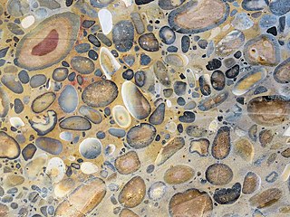
Puddingstone, also known as either pudding stone or plum-pudding stone, is a popular name applied to a conglomerate that consists of distinctly rounded pebbles whose colours contrast sharply with the colour of the finer-grained, often sandy, matrix or cement surrounding them. The rounded pebbles and the sharp contrast in colour gives this type of conglomerate the appearance of a raisin or Christmas pudding. There are different types of puddingstone, with different composition, origin, and geographical distribution. Examples of different types of puddingstones include the Hertfordshire, Schunemunk, Roxbury, and St. Joseph Island puddingstones.

Cuffley Brook is a tributary of Turkey Brook. It runs through parts of Hertfordshire and the London Borough of Enfield, England. After the confluence of the two streams in Whitewebbs Park, the watercourse continues eastwards as Turkey Brook to join the River Lea near Enfield Lock.

Michigan consists of two peninsulas surrounded primarily by four of the Great Lakes and a variety of nearby islands. The Upper Peninsula is bounded on the southwest by Wisconsin, and the Lower Peninsula is bounded on the south by Indiana and Ohio. Both land masses are also separated from the Canadian province of Ontario by waterways of the Great Lakes, and from each other by the Straits of Mackinac. Because its land is largely surrounded by the Great Lakes, which flow into the Saint Lawrence River, Michigan is the only U.S. state whose streams and rivers are almost entirely within the Great Lakes-St. Lawrence watershed.
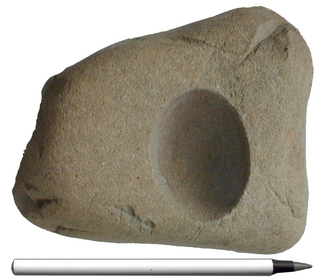
Omars, are a distinctive type of glacial erratic that consists of dark siliceous greywacke and exhibits prominent rounded, often deep, hemispherical voids and pits. The hemispherical voids and pits result from the selective dissolution of carbonate concretions within the greywacke. The greywacke is identifiable by its low metamorphic grade and the 10–40% rock fragments, distinctive volcanic clasts, and spherical carbonate concretions that it contains. Omars are typically rounded and range in size from pebbles to boulders. Their rounded shape, whether found in glacial tills or glacial-fluvial (outwash) gravels, indicate that they were eroded from pre-existing littoral or fluvial deposits. Omars are typically found associated with granules and pebbles of oolitic jasper that were transported from the Belcher Islands in Hudson Bay, Canada.

The Animikie Group is a geologic group composed of sedimentary and metasedimentary rock, having been originally deposited between 2,500 and 1,800 million years ago during the Paleoproterozoic era, within the Animikie Basin. This group of formations is geographically divided into the Gunflint Range, the Mesabi and Vermilion ranges, and the Cuyuna Range. On the map, the Animikie Group is the dark gray northeast-trending belt which ranges from south-central Minnesota, U.S., up to Thunder Bay, Ontario, Canada. The Gunflint Iron Range is the linear black formation labeled G, the Mesabi Iron Range is the jagged black linear formation labeled F, and Cuyuna Iron Range is the two black spots labeled E. The gabbro of the Duluth Complex, intruded during the formation of the Midcontinent Rift, separates the Mesabi and Gunflint iron ranges; it is shown by the speckled area wrapping around the western end of Lake Superior.
The Huronian Supergroup is a Proterozoic assemblage of geologic groups of the Superior craton of the Canadian Shield in Ontario and Quebec. It extends from west of the city of Sault Ste. Marie in the west to the Ontario-Quebec border to the east and is part of the Southern Geologic Province.

The Lufilian Arc is part of a system of orogenic belts in southern Africa formed during the Pan-African orogeny, a stage in the formation of the Gondwana supercontinent. It extends across eastern Angola, the Katanga Province of the southern Democratic Republic of the Congo and the northwest of Zambia. The arc is about 800 kilometres (500 mi) long. It has global economic importance owing to its rich deposits of copper and cobalt.
The Pongola glaciation is a glacial episode that occurred in the Mesoarchean, 2.9 Ga ago for about 150 Ma. It is the oldest known glaciation on the planet.

The geology of Ghana is primarily very ancient crystalline basement rock, volcanic belts and sedimentary basins, affected by periods of igneous activity and two major orogeny mountain building events. Aside from modern sediments and some rocks formed within the past 541 million years of the Phanerozoic Eon, along the coast, many of the rocks in Ghana formed close to one billion years ago or older leading to five different types of gold deposit formation, which gave the region its former name Gold Coast.

The geological history of Zambia begins in the Proterozoic eon of the Precambrian. The igneous and metamorphic basement rocks tend to be highly metamorphosed and may have formed earlier in the Archean, but heat and pressure has destroyed evidence of earlier conditions. Major sedimentary and metamorphic groups formed in the mid-Proterozoic, followed by a series of glaciations in the Neoproterozoic and much of the Paleozoic which deposited glacial conglomerate as well as other sediments to form the Katanga Supergroup and rift-related Karoo Supergroup. Basalt eruptions blanketed the Karoo Supergroup in the Mesozoic and Zambia shifted to coal and sandstone formation. Geologically recent windblown sands from the Kalahari Desert and alluvial deposits near rivers play an important role in the modern surficial geology of Zambia. The country has extensive natural resources, particularly copper, but also cobalt, emeralds, other gemstones, uranium and coal.

