
The Karakoram is a mountain range in the Kashmir region spanning the border of Pakistan, China, and India, with the northwestern extremity of the range extending to Afghanistan and Tajikistan. Most of the Karakoram mountain range falls under the jurisdiction of Gilgit-Baltistan, which is controlled by Pakistan. Its highest peak, K2, is located in Gilgit-Baltistan, Pakistan. It begins in the Wakhan Corridor (Afghanistan) in the west, encompasses the majority of Gilgit-Baltistan, Pakistan and extends into Ladakh and Aksai Chin. It is part of the larger Trans-Himalayan mountain ranges.

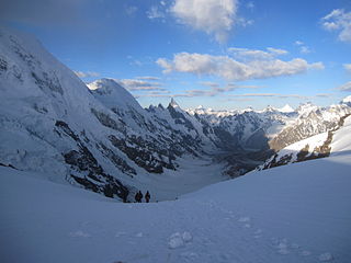
The Siachen Glacier is a glacier located in the eastern Karakoram range in the Himalayas at about 35.421226°N 77.109540°E, just northeast of the point NJ9842 where the Line of Control between India and Pakistan ends. At 76 km (47 mi) long, it is the longest glacier in the Karakoram and second-longest in the world's non-polar areas. It falls from an altitude of 5,753 m (18,875 ft) above sea level at its head at Indira Col on the India–China border down to 3,620 m (11,875 ft) at its terminus. The entire Siachen Glacier, with all major passes, has been under the administration of India as part of the union territory of Ladakh, located in the Kashmir region since 1984. Pakistan maintains a territorial claim over the Siachen Glacier and controls the region west of Saltoro Ridge, lying west of the glacier, with Pakistani posts located 1 km below more than 100 Indian posts on the ridge.

Nubra, also called Dumra, is a historical region of Ladakh, India that is currently administered as a subdivision and a tehsil in the Nubra district. Its inhabited areas form a tri-armed valley cut by the Nubra and Shyok rivers. Its Tibetan name Dumra means "valley of flowers". Demands have been raised and BJP has hinted at creation of Nubra as a new district. Diskit, the headquarters of Nubra, is 120 km north of Leh, the capital of Ladakh.

The Saltoro Mountains form a subrange within the Karakoram Range and are situated in the southeastern part of the Karakoram. They lie on the southwest side of the Siachen Glacier, which is one of the two longest glaciers in the world outside the polar regions. The name "Saltoro" is also associated with the Saltoro Valley, located west of this range and descending on the Pakistani side of the Saltoro Range, which generally follows the Actual Ground Position Line (AGPL).
The Rimo Muztagh is one of the most remote subranges of the Karakoram range. The southern part of Rimo Muztagh is in the Ladakh portion of far northwestern India, also claimed by Pakistan. The northern half, including the Rimo massif, is in the Siachen area. It is far from major towns, and close to the militarily sensitive Siachen Glacier, so it has seen little exploration or climbing activity compared to, for example, the nearby Baltoro Muztagh. The highest peak is Mamostong Kangri, 7,516 metres.

Gilgit-Baltistan is an administrative territory of Pakistan in the northern part of the country. It was given self-governing status on August 29, 2009. Gilgit-Baltistan comprises 14 districts within three divisions. The four districts of Skardu Kharmang Shigar and Ghanche are in the Baltistan Division, four districts of Gilgit Ghizer Hunza and Nagar districts which were carved out of Gilgit District are in the Gilgit Division and the third division is Diamir, comprising Chilas and Astore. The main political centres are the towns of Gilgit and Skardu.
Gondogoro Pass is a mountain pass that stands at an elevation of 5585 meters. It is located in the Baltistan region of Pakistan, approximately 25 km south of the world's second-highest peak, K2. This pass serves as a connection between the Gondogoro Glacier to the southwest and the Vigne Glacier to the northeast.

Ladakh is an administrative territory of India that has been under its control since 1947. The geographical region of Ladakh union territory is the highest altitude plateau region in India, incorporating parts of the Himalayan and Karakoram mountain ranges and the upper Indus River and valley.
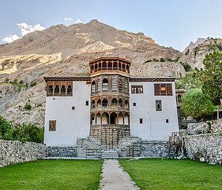
Khaplu, also spelt Khapalu, is a city that serves as the administrative capital of the Ghanche District in Pakistan-administered Gilgit-Baltistan, within the disputed Kashmir region. Located 103 km (64 mi) east of Skardu, Khaplu was historically the second-largest kingdom in Baltistan under the Yabgo dynasty and played a key role in guarding the trade route to Ladakh along the Shyok River, near its confluence with the Indus.

The Shyok River is a tributary of the Indus River that flows through northern Ladakh and enters Gilgit–Baltistan, in Pakistan, spanning some 550 km (340 mi).

The Nubra River is a river in the Nubra Valley of Ladakh in India. It is a tributary of the Shyok River and originates from the Siachen Glacier, the second-longest non-polar glacier in the world. In earlier Tibetan maps, it was referred to as Yarma Tsangpo.
NJ9842, also called NJ 980420, is the northernmost demarcated point of the India-Pakistan cease fire line in Kashmir known as the Line of Control (LoC). The India–Pakistan AGPL, begins from the NJ9842 on LoC and ends near the Indira Ridge at the trijunction of areas controlled by China, India, and Pakistan.

Hushe is the last village of the Ghangche District of Gilgit-Baltistan, Pakistan. It is the highest village in the once extremely remote and impoverished Hushe Valley. Hushe men began working as cooks and porters for mountaineering expeditions in the 1960s. Hushe is no longer the poorest of villages, as its popularity as a trekking and climbing destination continues to grow. Climbers and trekkers come all the way from Baltoro Glacier, Concordia and K2 via Gondogoro Pass, descend into Hushe village to reach Skardu District. Access to the Gasherbrums peaks is also possible going north up through Hushe Valley.
Khaney is a village in Ghanche District in the Gilgit-Baltistan region of Pakistan. It is located en route to Gondogoro Trek, which joins the Hushey Valley with K2 via Concordia.
Saltoro River is a tributary river of Shyok River in the Siachen Region. Its main source is Bilafond Glacier. The Saltoro river drains into the Hushe river at Haldi village which finally falls in the Shyok.

Hushe Valley is a valley in Ghanche District, Gilgit-Baltistan, Pakistan. Formed by the Hushe River, the valley runs from Masherbrum Mountain and nearby glaciers south to the Shyok River, opposite Khaplu. Hushe village lies in the center of the valley.
The Chip Chap River is a tributary of the Shyok River that flows from the disputed Aksai Chin region administered by China to Ladakh in India. It originates at the eastern edge of the Depsang Plains and flows west, skirting around the Depsang Plains in the north. It discharges into the Shyok River, forming one of the upstream tributaries of the Indus River.

Murgo, on "Murgo Nala" near Murgo Hotspring, is a small hilly village which lies near the Line of Actual Control in Leh district of the union territory of Ladakh in India, close to Chinese-controlled Aksai Chin. It is one of the northernmost villages of India. The Murgo Gompa is a large Buddhist monastery at Murgo. Murgo lies on the Darbuk–Shyok–DBO Road and Sasser Brangsa-Murgo Road fork of Sasoma–Sasser La-Saser Brangsa-Gapsam-Daulat Beg Oldi Road, both of which connect Leh to Daulat Beg Oldi. The village is inhabited by a small civilian population of Baltis, who make a living by apricot farming and yak rearing. The temperature plummets as low as -30 C in the winters. The weather deteriorates frequently with strong icy winds lashing much of Murgo. Murgo has very little vegetation or wildlife. Telecommunication at Murgo is only available through INMARSAT satellite phones. The Indian Armed Forces have significant presence in the area.

The Thalay Valley, located in the southeastern part of Baltistan within the Ghanche District of Gilgit-Baltistan, Pakistan, is a side valley of Khaplu Valley. The valley ascends from 2,500 meters above sea level to Thalay La, a pass at 4,576 meters. Khasurmik is the northernmost village in Upper Thalay, situated at an altitude of 3,150 meters. Stretching 40 km in length and about 20 km in width, the valley is situated along the Thalla River, which is part of the Shyok Basin. The river converges with the Shyok River at the southern end of the valley, near Daghoni Balgar.
