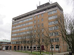
Huyton Municipal Building

Last updated

Huyton Municipal Building
Knowsley Metropolitan Borough Council building, Huyton.jpg
The building in 2012
LocationArchway Road, Huyton
Coordinates 53°24′42″N2°50′27″W / 53.4116°N 2.8407°W / 53.4116; -2.8407
Built1963
ArchitectHenry Kay Pilkinton
Architectural style(s) Modern style
Merseyside UK location map.svg
Red pog.svg
Shown in Merseyside

Huyton Municipal Building is a municipal building in Archway Road, Huyton, a town in Merseyside, England. The building currently serves as the headquarters of Knowsley Metropolitan Borough Council.

History

Following significant population growth, largely associated with the mining industry, a local board of health was established in Huyton-with-Roby in 1877. [1] Meetings of the local board were held at Huyton and Roby schools in Dam House Lane (now Rupert Road), but after the local board was succeeded by Huyton with Roby Urban District Council in 1895, the new council established its offices in a large redbrick building designed in the Victorian style on the east side of Derby Road. [2] [3] The building in Derby Road continued to serve as the offices and meeting place of the district council throughout the first half of the 20th century, [4] but by the middle of the century the area was very dilapidated. The old council offices and surrounding buildings were then demolished to make way for the Sherborne Square Shopping Centre. [5] [6]

A new building was commissioned as the first element of a wider redevelopment of Huyton town centre. The site the council selected was open land on the east side of Archway Road. [7] Construction work started on site in 1962. [8] The new building was designed under the supervision of the town surveyor, Henry Kay Pilkinton, [9] in the Modern style and was officially opened in November 1963. A larger building was added to the original two storey block in 1973/74. The design involved a main frontage of 13 bays facing southwest, with the northwest end facing onto Archway Road. It was eight storeys high and featured alternating bands of brown brick and glass. [10]

The building continued to serve as the headquarters of the district council for the next decade and then became the headquarters of the enlarged Knowsley Metropolitan Borough Council which was formed in 1974. [11] In December 2023 a joint venture between the charity, Genr8, and the Japanese developer, Kajima Regeneration, submitted proposals on behalf of Knowsley Council to demolish the building, [12] which the council described as "inefficient in terms of energy use and size", and to replace it with a new commercial district, which would incorporate new council offices and a village green. [13] [14] [15]

Related Research Articles

<span class="mw-page-title-main">Prescot</span> Town in England

Prescot is a town and civil parish within the Metropolitan Borough of Knowsley in Merseyside, United Kingdom. It lies about eight miles (13 km) to the east of Liverpool city centre. At the 2001 Census, the civil parish population was 11,184. The population of the larger Prescot East and West wards at the 2011 census totalled 14,139. Prescot marks the beginning of the A58 road which runs through to Wetherby, near Leeds in West Yorkshire. The town is served by Prescot railway station and Eccleston Park railway station in neighbouring Eccleston.

<span class="mw-page-title-main">Kirkby</span> Town in Merseyside, England

Kirkby is a town in the Metropolitan Borough of Knowsley, Merseyside, England. The town, historically in Lancashire, has a size of 4,070 acres (16.5 km2) is 5 miles (8 km) north of Huyton and 6 miles (10 km) north-east of Liverpool. The population in 2016 was 41,495 making it the largest in Knowsley and the 9th biggest settlement in Merseyside.

<span class="mw-page-title-main">Metropolitan Borough of Knowsley</span> Metropolitan borough in England

The Metropolitan Borough of Knowsley is a metropolitan borough in Merseyside, North West England. It covers several towns and villages, including Kirkby, Prescot, Huyton, Whiston, Halewood, Cronton and Stockbridge Village; Kirkby, Huyton, and Prescot being the major commercial centres. It takes its name from the village of Knowsley, though its headquarters are in Huyton. It forms part of the wider Liverpool City Region.

<span class="mw-page-title-main">Huyton</span> Town in England

Huyton is a town in the Metropolitan Borough of Knowsley, Merseyside, England. Part of the Liverpool Built-up Area, it borders the Liverpool suburbs of Dovecot, Knotty Ash and Netherley.

<span class="mw-page-title-main">Liverpool City Council</span> Local government body in England

Liverpool City Council is the local authority for the city of Liverpool in Merseyside, England. Liverpool has had a local authority since 1207, which has been reformed on numerous occasions. Since 1974 the council has been a metropolitan borough council. It provides the majority of local government services in the city. The council has been a member of the Liverpool City Region Combined Authority since 2014.

<span class="mw-page-title-main">Whiston, Merseyside</span> Town in England

Whiston is a town and civil parish within the Metropolitan Borough of Knowsley in Merseyside, England. Previously recorded within the historic county of Lancashire, it is located eight miles east of Liverpool and 3/4 mile east of Huyton Quarry. The population was 13,629 at the 2001 Census, increasing to 14,263 at the 2011 Census.

<span class="mw-page-title-main">Roby, Merseyside</span> Village in England

Roby is a village in the Metropolitan Borough of Knowsley, Merseyside, England. It was previously administratively linked with its neighbour Huyton by the Huyton-with-Roby civil parish and Huyton with Roby Urban District. Like Huyton, Roby is effectively a dormitory village or suburb of the neighbouring City of Liverpool. At the 2001 Census, the population of Roby was 9,353,. reducing to 7,254 at the 2011 Census. Roby is the location of the sixth form centre of Knowsley Community College.
<span class="mw-page-title-main">Municipal Buildings, Liverpool</span> Grade II listed building in Liverpool, England

Municipal Buildings is a former council office building that has been converted into a hotel. It is located on Dale Street in the centre of Liverpool, England. It is a Grade II* listed building.

<span class="mw-page-title-main">Knowsley (UK Parliament constituency)</span> Parliamentary constituency in the United Kingdom, 2010 onwards

Knowsley is a constituency represented in the House of Commons of the UK Parliament since its 2010 creation, it has been represented by the Labour Party. It is currently represented by Anneliese Midgley.

<span class="mw-page-title-main">Huyton railway station</span> Railway station in Merseyside, England

Huyton railway station serves Huyton in Merseyside, England. The station is an interchange between the Liverpool-Wigan Line and the northern route of the Liverpool-Manchester Line which diverge soon after the station. It is one of the busier stations on the lines and close to the shopping centre and bus station.

<span class="mw-page-title-main">Widnes (UK Parliament constituency)</span> Parliamentary constituency in the United Kingdom, 1885–1983

Widnes was a county constituency in England, based on the town of Widnes, in Lancashire. It returned one Member of Parliament (MP) to the House of Commons of the Parliament of the United Kingdom, elected by the first past the post voting system.
<span class="mw-page-title-main">Huyton (UK Parliament constituency)</span> Parliamentary constituency in the United Kingdom, 1950–1983

Huyton was a former constituency for the House of Commons. Created in 1950, it was centred on Huyton in Lancashire, North West England, just beyond the borders of the city of Liverpool. The only MP was frontbench Labour politician, Harold Wilson who while representing the seat became Leader of the Labour Party in 1963 and prime minister from 1964 to 1970 and again from 1974 to 1976.

<span class="mw-page-title-main">Knowsley Metropolitan Borough Council</span>

Knowsley Council, or Knowsley Metropolitan Borough Council, is the local authority of the Metropolitan Borough of Knowsley in Merseyside, England. It is a metropolitan borough council and provides the majority of local government services in the borough. The council has been a member of the Liverpool City Region Combined Authority since 2014.

Court Hey Park is a park in the Bowring Park suburb of Knowsley borough in Merseyside, England. It lies about 4+12 miles (7 km) east of Liverpool city centre.

<span class="mw-page-title-main">Halton Borough Council</span>

Halton Borough Council is the local authority for Halton, a local government district with borough status in the ceremonial county of Cheshire, England. Since 1998 the council has been a unitary authority, being a district council which also performs the functions of a county council. Since 2014 the council has been a member of the Liverpool City Region Combined Authority.

<span class="mw-page-title-main">Knowsley United F.C.</span> Football club

Knowsley United was an English football club based in what is now the Metropolitan Borough of Knowsley in Merseyside from 1963 to 1997. Founded in Kirkby as Kirkby Town, the club moved to Huyton in 1988 and took the name Knowsley United.

Court Hey Hall was a mansion in England built for Robertson Gladstone (1805–1875), elder brother of William Gladstone.

<span class="mw-page-title-main">Litherland Town Hall</span> Municipal building in Litherland, Merseyside, England

Litherland Town Hall is a former municipal building in Hatton Hill Road, Litherland, Merseyside, England. The structure, which was the headquarters of Litherland Urban District Council, now functions as a health centre.

<span class="mw-page-title-main">Prescot Town Hall</span> Municipal building in Prescot, Merseyside, England

Prescot Town Hall is a municipal building in Warrington Road, Prescot, a town in Merseyside, England. The building is currently used as the offices and meeting place of Prescot Town Council.

Kirkby Ski Slope was an artificial ski slope that was built in Kirkby, near Liverpool, England, in the 1970s. The ski slope never opened and was source of considerable controversy around how it was built and funded.
References

  1. Farrer, William; Brownbill, J. (1907). "'Townships: Huyton with Roby', in A History of the County of Lancaster". London. pp. 168–176. Archived from the original on 18 March 2016.
  2. "History of Huyton". Timetoast Timelines. Retrieved 21 February 2024.
  3. "Ordnance Survey Map". 1914. Retrieved 20 February 2024.
  4. "No. 41973". The London Gazette . 4 March 1960. p. 1634.
  5. New shopping centre for Huyton-with-Roby U.D.C. Vol. 88. Journal of the Institution of Municipal and County Engineers. 1961. p. 104.
  6. "Huyton". Historic Liverpool. Retrieved 20 February 2024.
  7. "Ordnance Survey Map". 1914. Retrieved 20 February 2024.
  8. "Work on new Huyton Town Centre begun: Council Offices first". Liverpool Echo. 9 May 1962. p. 7. Retrieved 28 August 2022.
  9. Appointments open. Vol. 122. The Surveyor and Municipal Engineer. 7 December 1963. p. 42.
  10. "Gift to council and Huyton members also get plaques". Liverpool Echo. 6 November 1963. p. 9. Retrieved 28 August 2022.
  11. Local Government Act 1972. 1972 c.70. The Stationery Office Ltd. 1997. ISBN   0-10-547072-4.
  12. Dukes, Emma (8 December 2023). "Municipal building to be demolished as part of major Huyton regeneration plans". Liverpool World. Retrieved 20 February 2024.
  13. McKeon, Christopher (9 December 2020). "New council HQ expected to kickstart Huyton's complete transformation". Liverpool Echo. Retrieved 20 February 2024.
  14. "Huyton's development plans take the next step forward". Knowsley News. 5 December 2023. Retrieved 20 February 2024.
  15. "Major step forward for Huyton development plans". Place North West. 6 December 2023. Retrieved 20 February 2024.