Artscape Nordland is an international art project that aims to bring art to people where they live, art museums being few and far apart in the sparsely populated county of Nordland.
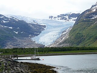
Svartisen is a collective term for two glaciers located in Nordland county in northern Norway. It is part of Saltfjellet-Svartisen National Park, located in the Saltfjell mountain range. The glaciers are located in the municipalities of Beiarn, Meløy, Rana, and Rødøy. Svartisen consists of two separate glaciers that are separated by the 1-kilometre (0.62 mi) long Vesterdalen valley. The two glaciers are:

Saltfjellet–Svartisen National Park is a national park in Nordland county in Norway. It is located within the municipalities of Beiarn, Meløy, Rana, Rødøy, Saltdal, and Bodø. European route E06 and the Nordland Line both follow the southern and eastern borders around the park. The park's eastern border is the Norway-Sweden border and a portion of this border is shared with the Vindelfjällen Nature Reserve which lies in Sweden.
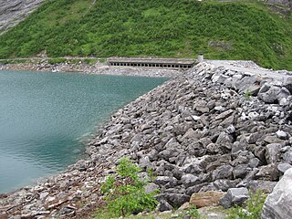
Arstaddalsdammen is a lake that lies in the municipality of Beiarn in Nordland county, Norway. It is located about 15 kilometres (9.3 mi) southwest of the village of Moldjord. The 2.54-square-kilometre (0.98 sq mi) lake lies in the southern end of the Arstaddal valley, and it has a dam on the northern end. The dam was built in the 1960s. The water from the lake is piped to the nearby lake Sokumvatnet in Gildeskål Municipality. The lake serves as a reservoir for the Sundsfjord Hydroelectric Power Station.

Litle Sokumvatnet is a lake that lies in Gildeskål Municipality in Nordland county, Norway. Litle Sokumvatnet lies directly northeast of the larger lake Sokumvatnet. The lake serves as a reservoir for the Forså Hydroelectric Power Station.
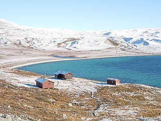
Nordre Bjøllåvatnet (Norwegian) or Bajep Ruovdajávrre (Lule Sami) is a lake that lies in the municipality of Saltdal in Nordland county, Norway. The 9.93-square-kilometre (3.83 sq mi) lake is located inside Saltfjellet–Svartisen National Park, about 1 kilometre (0.62 mi) east of the border with the municipality of Beiarn and north of the border with the municipality of Rana. The lake flows out through the river Bjøllåga and ultimately into the river Ranelva.

Ramsgjelvatnet is a lake that lies in the municipality of Beiarn in Nordland county, Norway. The lake is located about 5 kilometres (3.1 mi) northeast of the village of Høyforsmoen and about 15 kilometres (9.3 mi) southeast of the village of Moldjord.

Moldjord or Moldjorda is the administrative centre of the municipality of Beiarn in Nordland county, Norway. The village is located along the Beiar River, about 5 kilometres (3.1 mi) south of the river's mouth at the Beiar Fjord. The village is home to the Beiarn Church, the main church for the municipality. The village has about 150 residents.
Nygårdsjøen is a village area in the municipality of Gildeskål in Nordland county, Norway. Nygårdsjøen is located in the northern part of the municipality, close to the border with Bodø Municipality. The village lies along Norwegian County Road 17 on the east side of the Nordfjorden, just north of the entrance to the Beiar Fjord. Saura Church is located along the fjord on the west side of the village.

Saltfjellet is a mountain area in Nordland county, Norway that separates the two regions of Helgeland and Salten. It is also a cultural border between the Southern and Central parts of Sápmi.

Beiarn Church is a parish church of the Church of Norway in Beiarn Municipality in Nordland county, Norway. It is located in the village of Moldjord. It is the main church for the Beiarn parish which is part of the Salten prosti (deanery) in the Diocese of Sør-Hålogaland. The white, wooden church was built in a long church style in 1873 by the architect L.W. Nissen. The church seats about 310 people.

Høyforsmoen Chapel is a parish church of the Church of Norway in Beiarn Municipality in Nordland county, Norway. It is located in the village of Høyforsmoen. It is an annex church for the Beiarn parish which is part of the Salten prosti (deanery) in the Diocese of Sør-Hålogaland. The white, wooden church was built in a long church style in 1960 by the architect Andreas W. Nygaard. The church seats about 200 people.

Salten District Court is a district court located in the town of Bodø in Nordland county, Norway. The court serves the Salten district in the central part of the county as well as two outlying island municipalities. It includes the municipalities of Beiarn, Bodø, Fauske, Gildeskål, Meløy, Saltdal, Steigen, Sørfold, Værøy, and Røst. It also holds jurisdiction over the outlying territory of Jan Mayen. The court is subordinate to the Hålogaland Court of Appeal. The court is led by the chief judge Ingrid Johanne Lillevik. This court employs a chief judge, four other judges, and four prosecutors.

Láhko National Park is a national park in the municipalities of Gildeskål, Meløy, and Beiarn in Nordland county, Norway. The park contains unique geological features, including Norway's largest area of karst and caves. Rare plants and charales are also found inside the park. The park was established in December 2012 and covers an area of 188 km2 (73 sq mi).

The Beiar Valley is a valley in the municipality of Beiarn in Nordland, Norway. It is about 60 kilometers (37 mi) long. Most of the residents of the municipality of Beiarn live in this valley.
The Beiar River is a river in the municipality of Beiarn in Nordland, Norway. The river begins at the Svartisen glacier high in the mountains near the municipal borders of Beiarn, Meløy, and Rana inside the Saltfjellet-Svartisen National Park. The river then flows north and then west through the Beiar Valley to the head of Beiar Fjord. It has a length of about 54 kilometers (34 mi) and a drainage area of 1,052 square kilometers (406 sq mi), and is among the largest rivers in Nordland county.
Beiar Fjord is a fjord in Nordland, Norway. The fjord lies mostly within the municipality of Beiarn, but the westernmost part of the fjord lies in Gildeskål municipality. It has a length of about 20 kilometers (12 mi). The Norwegian County Road 17 crosses the fjord near the mouth via the Kjellingstraumen Bridge. The fjord ranges from 80 metres (260 ft) to 2 kilometres (1.2 mi) wide throughout its course.


