
Meldal is a municipality in Trøndelag county, Norway. It is part of the Orkdalen region. The administrative centre of the municipality is the village of Meldal. Other villages include Løkken Verk, Bjørnli, Å, and Storås.

Holtålen is a municipality in Trøndelag county, Norway. It is part of the Gauldalen region. The administrative centre of the municipality is located in the Ålen area of the village of Renbygda. Other villages in the municipality include Hessdalen, Aunegrenda, and Haltdalen.

Klæbu is a municipality in Trøndelag county, Norway. It is located in the southern part of the Trondheim Region, about 20 kilometres (12 mi) south of the city of Trondheim. The administrative center is the village of Klæbu. The other major village in Klæbu municipality is Tanem.

Malvik is a municipality in Trøndelag county, Norway. It is part of the Trondheim Region. The administrative center of the municipality is the village of Hommelvik. Other villages in Malvik include Muruvika, Smiskaret, Sneisen, Vikhammer, and Hundhammeren.

Selbu is a municipality in Trøndelag county, Norway. The administrative centre of the municipality is the village of Mebonden. Other villages in Selbu include Flora, Fossan, Hyttbakken, Innbygda, Selbustrand, Trøa, Tømra, and Vikvarvet.

Namsskogan is a municipality in Trøndelag, Norway. Namsskogan is located in the upper part of the long Namdalen valley region. The administrative centre of the municipality is the village of Namsskogan. Other villages in the municipality include Brekkvasselv, Smalåsen, Skorovatn, and Trones.

Grong (help·info) is a municipality in Trøndelag county, Norway. It is part of the Namdalen region. The administrative centre of the municipality is the village of Medjå. Other villages in the municipality include Bergsmoen, Formofoss, Gartland, and Harran.
Overhalla is a municipality in Trøndelag county, Norway. It is part of the Namdalen region. The administrative centre of the municipality is the village of Ranemsletta. Other villages include Melen, Skage, Skogmo, Svalia, and Øysletta.

Bindal is a municipality in the Helgeland region in the extreme southwest part of Nordland county, Norway. The administrative centre is the village of Terråk. Other villages include Bindalseidet, Holm, Vassås, Horsfjord and Åbygda.
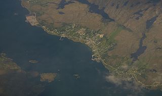
Sistranda is the administrative centre of the municipality of Frøya in Trøndelag county, Norway. The village is located on the east side of the island of Frøya, about 4 kilometres (2.5 mi) north of the village of Hammarvika and the entrance to the Frøya Tunnel. The 1.04-square-kilometre (260-acre) village has a population (2018) of 1,041 and a population density of 1,001 inhabitants per square kilometre (2,590/sq mi).

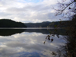
Almåsgrønningen is a lake in the municipality of Høylandet in Trøndelag county, Norway. The 3.8-square-kilometre (1.5 sq mi) lake lies about 10 kilometres (6.2 mi) northwest of the village of Høylandet, between the lakes Øyvatnet and Storgrønningen.
Storgrønningen is a lake in the municipality of Høylandet in Trøndelag county, Norway. The extreme southern tip of the lake crosses over the border into Overhalla municipality. The lake lies about 7.5 kilometres (4.7 mi) west of the village of Høylandet and about 4 kilometres (2.5 mi) southeast of the mountain Grønningfjella.
Støren (help·info) is the administrative centre of Midtre Gauldal municipality in Trøndelag county, Norway. The village is located in the Gauldalen valley at the confluence of the rivers Gaula and Sokna. Støren is located on the European route E06 highway, about 50 kilometres (31 mi) south of the city of Trondheim. The junction between the Dovrebanen and Rørosbanen railway lines is at Støren Station in the northern part of the village. Støren Church, a school, government services, and commercial and industrial sites are all located in the village.
Vassbotna is a village in the southern part of the municipality of Høylandet in Trøndelag county, Norway. The village is located on an isthmus between the lakes Eidsvatnet and Grungstadvatnet, about 11 kilometres (6.8 mi) southwest of the village of Høylandet and about 11 kilometres (6.8 mi) northeast of the village of Skogmo. Drageid Church is located in this village, and it serves the people in the southern part of Høylandet municipality.

Steinkjer is the administrative centre of the municipality of Steinkjer in Trøndelag county, Norway. The town is located at the northeastern end of the inner-most part of the Trondheimsfjorden, at the mouth of the river Steinkjerelva. In the eastern part of the town, the river of Figgja also flows into the fjord. The town is split in two by Steinkjerelva, creating the two traditional neighborhoods of Nordsia and Sørsia. Both the European route E6 highway and the Nordlandsbanen railway line run through the town, the latter serving the city at Steinkjer Station. Steinkjer Church and Egge Church are both located in the town.
Meldal or Meldal Sentrum is the administrative centre of Melhus municipality in Trøndelag county, Norway. The village is located in the Orkdalen valley, along the river Orkla. The village of Å lies about 8 kilometres (5.0 mi) to the south, the village of Løkken Verk lies about 10 kilometres (6.2 mi) to the north, and the village of Storås lies about 8 kilometres (5.0 mi) to the northwest.

Melhus is the administrative centre of Melhus municipality in Trøndelag county, Norway. The village is located in the lower Gauldalen valley, along the river Gaula, about 15 kilometres (9.3 mi) south of the city of Trondheim. The 2.88-square-kilometre (710-acre) village has a population (2018) of 6,393 and a population density of 2,220 inhabitants per square kilometre (5,700/sq mi).

Røyrvik (Norwegian) or Raarvihke (Southern Sami) is the administrative centre in Røyrvik municipality in Trøndelag county, Norway. The village is located in the central part of the municipality, about 20 kilometres (12 mi) west of the border with Sweden. It sits at the northern end of the large lake Limingen. Børgefjell National Park is located about 20 kilometres (12 mi) to the north. Røyrvik Church is located in the village.
Namsskogan is the administrative centre of Namsskogan municipality in Trøndelag county, Norway. The village is located in the Namdalen valley on an island in the middle of the river Namsen, although it also includes land on both sides of the river. The European route E06 highway and the Nordlandsbanen railway line both run through the village, with the train stopping at Namsskogan Station. The village of Brekkvasselv lies about 12 kilometres (7.5 mi) to the south. Bjørhusdal Church is located about 4 kilometres (2.5 mi) west of the village.


