
The Tohono Oʼodham are a Native American people of the Sonoran Desert, residing primarily in the U.S. state of Arizona and the northern Mexican state of Sonora. The United States federally recognized tribe is the Tohono Oʼodham Nation.

The Pimería Alta was an area of the 18th century Sonora y Sinaloa Province in the Viceroyalty of New Spain, that encompassed parts of what are today southern Arizona in the United States and northern Sonora in Mexico.

The Salt River is a river in Gila and Maricopa counties in Arizona, United States, that is the largest tributary of the Gila River. The river is about 200 miles (320 km) long. Its drainage basin covers about 13,700 square miles (35,000 km2). The longest of the Salt River's many tributaries is the 195-mile (314 km) Verde River. The Salt's headwaters tributaries, the Black River and East Fork, increase the river's total length to about 300 miles (480 km). The name Salt River comes from the river's course over large salt deposits shortly after the merging of the White and Black Rivers.
Oʼodham or Papago-Pima is a Uto-Aztecan language of southern Arizona and northern Sonora, Mexico, where the Tohono Oʼodham and Akimel Oʼodham reside. In 2000 there were estimated to be approximately 9,750 speakers in the United States and Mexico combined, although there may be more due to underreporting.
The Akimel O'odham, also called the Pima, are a group of Native Americans living in an area consisting of what is now central and southern Arizona, as well as northwestern Mexico in the states of Sonora and Chihuahua. The majority population of the two current bands of the Akimel O'odham in the United States are based in two reservations: the Keli Akimel Oʼodham on the Gila River Indian Community (GRIC) and the On'k Akimel O'odham on the Salt River Pima-Maricopa Indian Community (SRPMIC).

The Maricopa or Piipaash are a Native American tribe, who live in the Salt River Pima-Maricopa Indian Community and Gila River Indian Community along with the Pima, a tribe with whom the Maricopa have long held a positive relationship. The Maricopa at the Salt River Pima-Maricopa Indian Community consist mostly of Xalychidom Piipaash members and are concentrated in Lehi. The Maricopa at the Gila River Indian Community are concentrated in Maricopa Colony. The Maricopa are a River Yuman group, formerly living along the banks of the Colorado River.
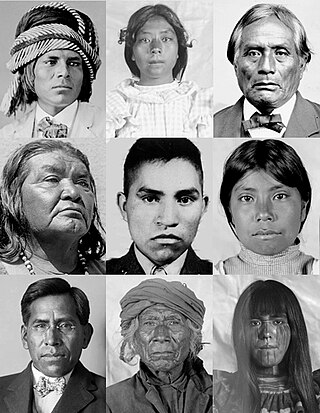
Indigenous peoples of Arizona are the Native American people who currently live or have historically lived in what is now the state of Arizona. There are 22 federally recognized tribes in Arizona, including 17 with reservations that lie entirely within its borders. Reservations make up over a quarter of the state's land area. Arizona has the third largest Native American population of any U.S. state.

The Hohokam Pima National Monument is an ancient Hohokam village within the Gila River Indian Community, near present-day Sacaton, Arizona. The monument features the archaeological site Snaketown 30 miles (48 km) southeast of Phoenix, Arizona, designated a National Historic Landmark in 1964. The area was further protected by declaring it a national monument in 1972, and was listed on the National Register of Historic Places in 1974.
The O'odham peoples, including the Tohono O'odham, the Pima or Akimel O'odham, and the Hia C-ed O'odham, are indigenous Uto-Aztecan peoples of the Sonoran desert in southern and central Arizona and northern Sonora, united by a common heritage language, the O'odham language. Today, many O'odham live in the Tohono O'odham Nation, the San Xavier Indian Reservation, the Gila River Indian Community, the Salt River Pima-Maricopa Indian Community, the Ak-Chin Indian Community or off-reservation in one of the cities or towns of Arizona.

The Salt River Pima–Maricopa Indian Community (SRPMIC) comprises two distinct Native American tribes—the Pima and the Maricopa —many of whom were originally part of the Halchidhoma (Xalchidom) tribe. The community was permanently created by an Executive Order of US President Rutherford Birchard Hayes on June 14th, 1879. The community area includes 53,600 acres (217 km2), of which 19,000 remain a natural preserve. As of 2022, the total population is 7,386. The community is a federally recognized tribe located in Arizona.

The Baboquivari Peak Wilderness or La Bestia is a 2,065-acre (8 km2) wilderness area in the U.S. state of Arizona. It is located in the Baboquivari Mountains 50 miles (80 km) southwest of Tucson, Arizona. It is administered by the Bureau of Land Management. The United States Congress designated the Baboquivari Peak Wilderness in 1990. It is the smallest such designated wilderness in the state of Arizona. Today, the 2,900,000-acre (12,000 km2) Tohono O'odham Nation lies to the west. Baboquivari Peak's elevation is 7,730 feet. It is a popular site for many climbers, tourists and other visitors to Arizona and can be seen in the distance from the Kitt Peak National Observatory. The mountain was well known as a place to find flint for arrow points. BA BO QUAY VI RA, is translated as the place for the mother lode of flint.
The Sobaipuri were one of many indigenous groups occupying Sonora and what is now Arizona at the time Europeans first entered the American Southwest. They were a Piman or O'odham group who occupied southern Arizona and northern Sonora in the 15th–19th centuries. They were a subgroup of the O'odham or Pima, surviving members of which include the residents of San Xavier del Bac which is now part of the Tohono O'odham Nation and the Akimel O'odham.

The history of Phoenix, Arizona, goes back millennia, beginning with nomadic paleo-Indians who existed in the Americas in general, and the Salt River Valley in particular, about 7,000 BC until about 6,000 BC. Mammoths were the primary prey of hunters. As that prey moved eastward, they followed, vacating the area. Other nomadic tribes moved into the area, mostly from Mexico to the south and California to the west. Around approximately 1,000 BC, the nomadic began to be accompanied by two other types of cultures, commonly called the farmers and the villagers, prompted by the introduction of maize into their culture. Out of these archaic Indians, the Hohokam civilization arose. The Hohokam first settled the area around 1 AD, and in about 500 years, they had begun to establish the canal system which enabled agriculture to flourish in the area. They suddenly disappeared by 1450, for unknown reasons. By the time the first Europeans arrived at the beginning of the 16th century, the two main groups of native Indians who inhabited the area were the O'odham and Sobaipuri tribes.
La Pintada is an archaeological site located some 60 kilometers south of the city of Hermosillo, Sonora, Mexico, within the "La Pintada" canyon, part of the "Sierra Libre", a small mountain massif of the coastal plains that extends throughout the Sonoran Desert.

Indian Mesa is a flat top hill whose sides are steep cliffs. Indian Mesa is located within the Lake Pleasant Regional Park grounds by the shores of Lake Pleasant and Agua Fria River in the Bradshaw Mountain Range. Lake Pleasant Regional Park is within the municipal boundaries of Peoria, Arizona. On top of the mesa there are ruins of a prehistoric Hohokam village which is monitored by the Arizona Site Stewards and considered an important archaeological site by the U.S. Bureau of Land Management. There is a small, steep and narrow path which begins at the skirt of the hill and leads to the top of the mesa.
Pima Villages, sometimes mistakenly called the Pimos Villages in the 19th century, were the Akimel O’odham (Pima) and Pee-Posh (Maricopa) villages in what is now the Gila River Indian Community in Pinal County, Arizona. First, recorded by Spanish explorers in the late 17th century as living on the south side of the Gila River, they were included in the Viceroyalty of New Spain, then in Provincias of Sonora, Ostimuri y Sinaloa or New Navarre to 1823. Then from 1824 to 1830, they were part of the Estado de Occidente of Mexico and from September 1830 they were part of the state of Sonora. These were the Pima villages encountered by American fur trappers, traders, soldiers and travelers along the middle Gila River from 1830s into the later 19th century. The Mexican Cession following the Mexican American War left them part of Mexico. The 1853 Gadsden Purchase made their lands part of the United States, Territory of New Mexico. During the American Civil War, they became part of the Territory of Arizona.

Levi Ruggles (1824–1889) known as the "Father of Florence, Arizona" was a soldier and pioneer who founded the town of Florence, Arizona.

The Indigenous peoples of the North American Southwest are those in the current states of Colorado, Arizona, New Mexico, Utah, and Nevada in the western United States, and the states of Sonora and Chihuahua in northern Mexico. An often quoted statement from Erik Reed (1666) defined the Greater Southwest culture area as extending north to south from Durango, Mexico to Durango, Colorado and east to west from Las Vegas, Nevada to Las Vegas, New Mexico. Other names sometimes used to define the region include "American Southwest", "Northern Mexico", "Chichimeca", and "Oasisamerica/Aridoamerica". This region has long been occupied by hunter-gatherers and agricultural people.
Maria Chona (1845-1936) was a native American weaver and participant in anthropological research.
