Tamanrasset or Tamanghasset is the largest province (wilaya) in Algeria. It was named after its province seat, Tamanrasset. The province has two national parks, more than any other in Algeria. They are Tassili n'Ajjer National Park and Ahaggar National Park. The province is the largest in Algeria as it is 557,906 km2 large.

Tuat, or Touat, is a natural region of desert in central Algeria that contains a string of small oases. In the past, the oases were important for caravans crossing the Sahara.

In Guezzam is a town and commune that is the capital of In Guezzam Province, Algeria, on the border with Niger. Until 26 November 2019, it was a part of the Tamanrasset Province. The border town on the Niger side is Assamaka. According to the 2008 census it had a population of 7,045, up from 4,938 in 1998, with an annual growth rate of 3.7%, the second highest in the Tamanrasset province's 2008 boundaries.
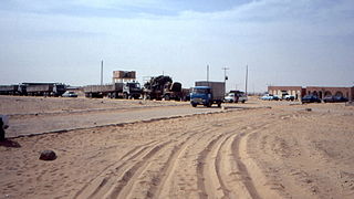
Assamakka is a small desert town in northern Niger at a main border crossing with Algeria. It is the only official crossing point between the two nations. Assamakka shares the border with the larger town of In Guezzam 10 km on the Algerian side. A main road extends north in Algeria to Tamanrasset, 400 km away. Assamakka is connected to the town of Arlit, 200 km to the south by a road which remains in largely a sand "Piste". From Arlit, the "Uranium Highway", a tarred road built in the 1970s for mining trucks, travels south to Agadez and Niamey.

Bordj Badji Mokhtar is a town and commune in Bordj Badji Mokhtar District, Bordj Badji Mokhtar Province, in south-western Algeria. According to the 2008 census it has a population of 16,437, up from 9,323 in 1998, with an annual growth rate of 6.0%, the highest in the province. It was named after the Algerian independence activist Badji Mokhtar (1919–1954). The inhabitants are mainly Tuaregs.

Tamanrasset, also known as Tamanghasset or Tamenghest, is an oasis city and capital of Tamanrasset Province in southern Algeria, in the Ahaggar Mountains. It is the chief city of the Algerian Tuareg. It is located an altitude of 1,320 metres (4,330 ft). As of the 2008 census, it has a population of 92,635, up from 72,741 in 1998, with an annual growth rate of 2.5%.

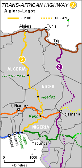
The Trans-Sahara Highway or TAH 2, formally the Trans-Saharan Road Corridor (TSR), and also known as the African Unity Road, is a transnational infrastructure project to facilitate trade, transportation, and regional integration among six African countries: Algeria, Chad, Mali, Niger, Nigeria, and Tunisia. It runs roughly 4,500 km north to south across the Sahara desert from Algiers, Algeria on the Mediterranean coast of North Africa to Lagos, Nigeria on the Atlantic coast of West Africa; subsequently, it is sometimes known as the Algiers–Lagos Highway or Lagos–Algiers Highway.

Abalessa is a town and commune in Tamanrasset Province, in southern Algeria, coextensive with the district of the same name. According to the 2008 census it has a population of 9,163 up from 6,484 in 1998, with an annual growth rate of 3.6%. Abalessa is located along the ancient Trans-Saharan trade route, 80 kilometres (50 mi) west of the city of Tamanrasset, the capital of the province. The postcode of the town is 11120.

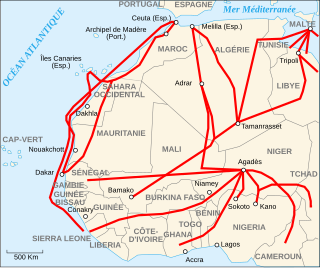
Migrants' routes encompass the primary geographical routes from tropical Africa to Europe, which individuals undertake in search of residence and employment opportunities not available in their home countries. While Europe remains the predominant destination for most migrants, alternate routes also direct migrants towards South Africa and Asia.

Tin Zaouatine is a commune, coextensive with the district of Tin Zaouatine, in In Guezzam Province, Algeria. According to the 2008 census it has a population of 4,157, up from 2,314 in 1998, with an annual growth rate of 6.2%, the highest rate in the province. Its postal code is 11150 and its municipal code is 1107.

Idlès is a municipality in Tazrouk District, Tamanrasset Province, Algeria. According to the 2008 census it has a population of 4,945, up from 3,791 in 1998, with an annual growth rate of 2.7%. Its postal code is 11110 and its municipal code is 1105. The largest nearby city is Tamanrasset; other smaller towns include In Amguel to the west and Tazrouk to the south.

Timiaouine is a town and commune in Bordj Badji Mokhtar District, Bordj Baji Mokhtar Province, in southwest Algeria near the border with Mali. According to the 2008 census it has a population of 4,493, up from 4,206 in 1998, with an annual growth rate of 0.7%, the lowest rate in the province.
The 1974 London–Sahara–Munich World Cup Rally, known also under the commercial identity of 1974 UDT World Cup Rally, was the second and final of the World Cup Rallies to be held. Drawing inspiration from the 1974 FIFA World Cup which was held in Munich, the rally began in London, Great Britain and travelled to Munich, Germany, via Nigeria. It was won by the privateer Australian crew of Jim Reddiex, Ken Tubman and André Welinski, driving a Citroën DS.
Georges Estienne was a French aviator, explorer and businessman. He mapped and commercially exploited the longest automobile route in the world, linking the Mediterranean to the Niger, Chad and Congo. His company ran a network of automobile transport lines across the Sahara, and later provided air service between many of the French colonies in Africa. The demand from tourists collapsed with the Algerian War (1954–62), and eventually Estienne's companies were taken over by the government of independent Algeria.

Conflicts between the Regency of Algiers and the Cherifian dynasties or Algerian-Sherifian conflicts opposed Morocco to the Ottoman Empire and its dependencies in a series of wars between the Regency of Algiers and its allied local sultanates and tribal confederations, and on the other hand, the Sharifian Saadian and Alawite dynasties that had ruled Morocco since the 16th century.

Bir el-Garama is a well in the south of Algeria in Tamanrasset Province, 150 kilometres (93 mi) northeast of Tamanrasset, known as the site where a large part of the French colonial Flatters Expedition was wiped out by Tuaregs. It is better known on French maps by its Tamahaq language name: Tagmout T-an Koufar, or 'well of the foreigner'.

The Algeria–Niger border is 951 kilometres in length and runs from the tripoint with Mali in the west to the tripoint with Libya in the east.

The Algeria–Mali border is 1,359 km long from the tripoint with Mauritania in the northwest to the tripoint with Niger in the southeast.

The wilaya of Djanet is an Algerian province created in 2019, previously, a delegated wilaya created in 2015. It is located in the Algerian Sahara.

Bordj Badji Mokhtar is an Algerian province (wilaya) in the Algerian Sahara. It was created in 2019 from the Adrar Province and had a population of 16,437 in 2008.


