IPO station

Last updated
IPO
Porto Metro station
IPO 20120822 (1).jpg
General information
Location Portugal
Coordinates 41°10′52″N8°36′16″W / 41.18122°N 8.60454°W / 41.18122; -8.60454
Line(s) Metro do Porto linha D.svg Metro do Porto linha E.svg
Platforms2 side platforms
Tracks2
Construction
Structure typeAt Grade
AccessibleYes
History
Opened31 March 2006
Services
Preceding station  Porto Metro  Following station
Lapa
toward Senhor de Matosinhos
  Line A   Bolhão
toward Estádio do Dragão
Lapa
toward Póvoa de Varzim
  Line B  
Lapa
toward ISMAI
  Line C   Bolhão
toward Campanhã
Faria Guimarães
toward Hospital São João
  Line D   Aliados
toward Santo Ovídio
Lapa
toward Aeroporto
  Line E  Terminus
Lapa
toward Senhora da Hora
  Line F   Bolhão
toward Fânzeres
Porto Metro
Routes [1] [2]
BSicon KBHFa.svg
Póvoa de Varzim
BSicon STR+GRZq.svg
BSicon pBHF.svg
São Brás
BSicon BHF.svg
Portas Fronhas
BSicon pBHF.svg
Alto do Pega
BSicon BHF.svg
Vila do Conde
BSicon pBHF.svg
Santa Clara
BSicon pBHF.svg
Azurara
BSicon pBHF.svg
Árvore
BSicon BHF.svg
Varziela
BSicon pBHF.svg
Espaço Natureza
BSicon BHF.svg
Mindelo
BSicon pBHF.svg
Modivas Centro
BSicon pBHF.svg
Modivas Sul
BSicon pBHF.svg
Vilar do Pinheiro
BSicon STR+GRZq.svg
BSicon pBHF.svg
Lidador
BSicon FLUG.svg Aeroporto
BSicon KBHFa purple.svg
BSicon BHF.svg
Pedras Rubras
Botica
BSicon BHF purple.svg
BSicon cSTRc2.svg
BSicon STR3.svg
Verdes
BSicon dBHF-L purple.svg
BSicon dpBHF+1-R.svg
BSicon STRc4.svg
Crestins
BSicon dBHF-L purple.svg
BSicon dpBHF-R.svg
Esposade
BSicon dBHF-L purple.svg
BSicon dpBHF-R.svg
BSicon fKBHFa.svg
ISMAI
Custóias
BSicon dBHF-L purple.svg
BSicon dpBHF-R.svg
BSicon fBHF.svg
Castêlo da Maia
BSicon dSTR purple.svg
BSicon dSTR.svg
BSicon fBHF.svg
Mandim
Senhor de Matosinhos
BSicon uKBHFa.svg
BSicon dSTR purple.svg
BSicon dSTR.svg
BSicon fBHF.svg
Zona Industrial
Mercado
BSicon uBHF.svg
BSicon dSTR purple.svg
BSicon dSTR.svg
BSicon fBHF.svg
Fórum da Maia
Brito Capelo
BSicon uBHF.svg
BSicon dSTR purple.svg
BSicon dSTR.svg
BSicon fBHF.svg
Parque da Maia
Matosinhos Sul
BSicon uBHF.svg
BSicon GRZl.svg
BSicon GRZq.svg
BSicon dSTR purple.svg
BSicon dSTR.svg
BSicon fSTR+GRZq.svg
Câmara de Matosinhos
BSicon uBHF.svg
BSicon dSTR purple.svg
BSicon dSTR.svg
BSicon fBHF.svg
Custió
Parque Real
BSicon uBHF.svg
BSicon dSTR purple.svg
BSicon dSTR.svg
BSicon fBHF.svg
Araújo
Pedro Hispano
BSicon uBHF.svg
BSicon dSTR purple.svg
BSicon dSTR.svg
BSicon fBHF.svg
Pias
Estádio do Mar
BSicon uBHF.svg
BSicon dSTR purple.svg
BSicon dSTR.svg
BSicon fBHF.svg
Cândido dos Reis
Vasco da Gama
BSicon uBHF.svg
BSicon dBHF-L purple.svg
BSicon dpBHF-M.svg
BSicon fdSHI1+l.svg
BSicon fdKBHFa-M.svg
BSicon flBHF~R.svg
BSicon fSHI1c4.svg
Fonte do Cuco
Senhora da Hora
BSicon udBHF-L.svg
BSicon dKBHFa-M orange.svg
BSicon dBHF-M purple.svg
BSicon dBHF-M.svg
BSicon fdBHF-R.svg
Sete Bicas
BSicon udBHF-L.svg
BSicon dBHF-M orange.svg
BSicon dBHF-M purple.svg
BSicon dBHF-M.svg
BSicon fdBHF-R.svg
BSicon GRZq.svg
BSicon udSTR.svg
BSicon dSTR orange.svg
BSicon GRZq.svg
BSicon dSTR purple.svg
BSicon dSTR.svg
BSicon GRZr+1.svg
BSicon fdSTR.svg
BSicon KBHFa yellow.svg
Hospital de São João
Viso
BSicon udBHF-L.svg
BSicon dBHF-M orange.svg
BSicon dBHF-M purple.svg
BSicon dBHF-M.svg
BSicon fdBHF-R.svg
BSicon BHF yellow.svg
IPO
Ramalde
BSicon udBHF-L.svg
BSicon dBHF-M orange.svg
BSicon dBHF-M purple.svg
BSicon dBHF-M.svg
BSicon fdBHF-R.svg
BSicon BHF yellow.svg
Pólo Universitário
Francos
BSicon udBHF-L.svg
BSicon dBHF-M orange.svg
BSicon dBHF-M purple.svg
BSicon dBHF-M.svg
BSicon fdBHF-R.svg
BSicon BHF yellow.svg
Salgueiros
Casa da Música
BSicon udBHF-L.svg
BSicon dBHF-M orange.svg
BSicon dBHF-M purple.svg
BSicon dBHF-M.svg
BSicon fdBHF-R.svg
BSicon BHF yellow.svg
Combatentes
Carolina Michaëlis
BSicon udBHF-L.svg
BSicon dBHF-M orange.svg
BSicon dBHF-M purple.svg
BSicon dBHF-M.svg
BSicon fdBHF-R.svg
BSicon BHF yellow.svg
Marquês
Lapa
BSicon udBHF-L.svg
BSicon dBHF-M orange.svg
BSicon dBHF-M purple.svg
BSicon dBHF-M.svg
BSicon fdBHF-R.svg
BSicon BHF yellow.svg
Faria Guimarães
BSicon STR+l yellow.svg
BSicon udINT-L.svg
BSicon dSTRq yellow.svg
BSicon dINT-M orange.svg
BSicon dINT-M purple.svg
BSicon dINT-M.svg
BSicon fdINT-R.svg
BSicon dSTRq yellow.svg
BSicon STRr yellow.svg
Trindade
BSicon BRILL.svg Aliados
BSicon BHF yellow.svg
BSicon udBHF-L.svg
BSicon dBHF-M orange.svg
BSicon dBHF-M purple.svg
BSicon dBHF-M.svg
BSicon fdBHF-R.svg
Bolhão
BSicon FUNI.svg Aiga railtransportation 25.svg BSicon BRILL.svg São Bento
BSicon BHF yellow.svg
BSicon udBHF-L.svg
BSicon dBHF-M orange.svg
BSicon dBHF-M purple.svg
BSicon dBHF-M.svg
BSicon fdBHF-R.svg
Campo 24 de Agosto
BSicon GRZ2+r.svg
BSicon STR yellow.svg
BSicon udBHF-L.svg
BSicon dBHF-M orange.svg
BSicon dBHF-M purple.svg
BSicon dBHF-M.svg
BSicon fdBHF-R.svg
Heroismo
BSicon AETRAM.svg Jardim do Morro
BSicon BHF yellow.svg
BSicon udBHF-L.svg
BSicon dBHF-M orange.svg
BSicon dBHF-M purple.svg
BSicon dBHF-M.svg
BSicon fdKBHFe-R.svg
Campanhã Aiga railtransportation 25.svg
Aiga railtransportation 25.svg General Torres
BSicon BHF yellow.svg
BSicon udKBHFe-L.svg
BSicon dBHF-M orange.svg
BSicon dKBHFe-M purple.svg
BSicon dKBHFe-R.svg
Estádio do Dragão
Câmara de Gaia
BSicon BHF yellow.svg
BSicon BHF orange.svg
Contumil Aiga railtransportation 25.svg
João de Deus
BSicon BHF yellow.svg
BSicon BHF orange.svg
Nasoni
D. João II
BSicon BHF yellow.svg
BSicon BHF orange.svg
Nau Vitória
Santo Ovídio
BSicon KBHFe yellow.svg
BSicon GRZl+4.svg
BSicon STR orange.svg
BSicon BHF orange.svg
Levada
BSicon BHF orange.svg
Rio Tinto Aiga railtransportation 25.svg
BSicon BHF orange.svg
Campainha
BSicon BHF orange.svg
de Baguim
BSicon BHF orange.svg
de Carreira
BSicon BHF orange.svg
Venda Nova
BSicon KBHFe orange.svg
de Fânzeres

BSicon uBHFq.svg Line A • BSicon pBHFq.svg BSicon BHFq.svg Line B • BSicon BHFq.svg Line Bx
BSicon fBHFq.svg Line C • BSicon BHFq yellow.svg Line D • BSicon BHFq purple.svg Line E • BSicon BHFq orange.svg Line F

IPO is a station on Line D (yellow line) of the Porto Metro, Portugal.

The station is at the northern end of the University of Porto campus and is named after the nearby Instituto Português de Oncologia (Portuguese Oncology Institute).

Although Line D opened in 2005, the IPO and Hospital de São João stations did not open until March 2006. The Escola Superior de Enfermagem, a nursing school, objected to the new line because of safety concerns from the trains running near the entrance of the school. The sidewalk was set back and a traffic light was placed at the intersection to reduce the risk of accidents between trains and cars. [3] The opening extended Line D to Hospital de São João station.

Before this time the line terminated at the preceding Pólo Universitário station. The line operates as a ground-level tram at this station.

See also

Related Research Articles

<span class="mw-page-title-main">Porto</span> Municipality in Norte, Portugal

Porto, also known in English as Oporto, is the second largest city in Portugal after Lisbon, the capital of the Porto District, and one of the Iberian Peninsula's major urban areas. Porto city proper, which is the entire municipality of Porto, is small compared to its metropolitan area, with an estimated population of just 231,800 people in a municipality with only 41.42 km2 (16 sq mi). Porto's metropolitan area has around 1.7 million people (2021) in an area of 2,395 km2 (925 sq mi), making it the second-largest urban area in Portugal. It is recognized as a global city with a Gamma + rating from the Globalization and World Cities Research Network.

<span class="mw-page-title-main">São Paulo Metro</span> Rapid transit system in São Paulo, Brazil

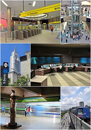
The São Paulo Metro, commonly called the Metrô is a rapid transit system that forms part of the urban railways that serves the city of São Paulo, alongside the São Paulo Metropolitan Trains Company (CPTM), both forming the largest metropolitan rail transport network of Latin America. The six lines in the metro system operate on 104.4 kilometres (64.9 mi) of route, serving 89 stations. The metro system carries about 4,000,000 passengers a day.

<span class="mw-page-title-main">Porto Metro</span> Mass transit system in Porto, Portugal

The Porto Metro, part of the public transport system of Porto, Portugal, is a light rail network that runs underground in central Porto and above ground into the city's suburbs. Metro do Porto S.A. was founded in 1993, and the first line of the system opened in 2002.

<span class="mw-page-title-main">Rio de Janeiro Metro</span> Rapid transit network serving Rio de Janeiro, Brazil

The Rio de Janeiro Metro, commonly referred to as just the Metrô is a rapid transit network that serves the city of Rio de Janeiro, Brazil. The Metrô was inaugurated on 5 March 1979, and consisted of five stations operating on a single line. The system currently covers a total of 58 kilometres (36 mi), serving 41 stations, divided into three lines: Line 1 ; Line 2, which together travel over a shared stretch of line that covers 10 stations of an approximate distance of 5 kilometres (3.1 mi); and Line 4. Metrô Rio has the second highest passenger volume of the metro systems in Brazil, after the São Paulo Metro.

<span class="mw-page-title-main">Transport in Póvoa de Varzim</span>

Póvoa de Varzim' is served by a transportation network that employs maritime, aerial and terrestrial travel. The terrestrial access infrastructure is composed of national motorways (freeways), the national roads system, and light rail metro. These infrastructures and the airport, bus terminal, marina and harbour are daily used by commuters.

The CP Urban Services network is the commuter train network of Metropolitan Lisbon and Metropolitan Porto, Portugal. It is a Comboios de Portugal company. It connects the city centers with the suburbs.

<span class="mw-page-title-main">Fortaleza Metro</span> Urban rail transit system in Fortaleza, Brazil

The Metropolitan of Fortaleza, also known popularly as Metro of Fortaleza or Metrofor, is a system of metropolitan transport that operates in the Brazilian city of Fortaleza, operated by Companhia Cearense de Transportes Metropolitanos, company of social capital, captained by the Government of the State of Ceará, in Brazil, and has as current president Eduardo Hotz. Founded on May 2, 1997, the company is responsible for administration, construction and metro planning in the state of Ceará, being present in the systems of Sobral and Cariri, having its main activity in Fortaleza and its metropolitan region.

<span class="mw-page-title-main">Porto Alegre Metro</span> Rapid transit system in Porto Alegre

The Porto Alegre Metro is a transit system operated jointly by the federal government, the state government of Rio Grande do Sul and the city of Porto Alegre through the company Trensurb in Brasil. It has 22 stations, totaling 43.8 kilometers (27.2 mi) of route, and carries about 175,000 users a day.

<span class="mw-page-title-main">Santa Apolónia railway station</span> Railway station in Portugal

The Santa Apolónia Station is the oldest railway terminus in Portugal. It is situated in the civil parish of São Vicente, in the central part of the municipality of Lisbon, on the northern margin of the Tagus River in the historical district of Alfama.

<span class="mw-page-title-main">Metro Mondego</span>

The Metro Mondego, part of the mass transit public transport system of Coimbra, Portugal, was to have been a light-rail network that runs above ground in Coimbra into the city's suburbs. Studies and planning were in progress but the Metro Mondego project was cancelled in January 2011 at the height of Portuguese financial crisis. The operational conventional rail line connecting the municipalities of: Coimbra, Miranda do Corvo, Lousã, and Serpins was closed at the same time and replaced by a bus service.

<span class="mw-page-title-main">São Bento railway station</span> Railway station in Porto, Portugal

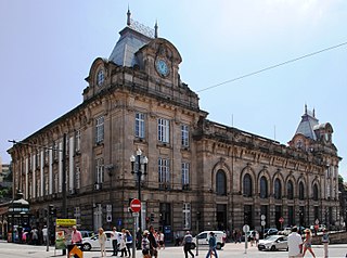
São Bento railway station is a 20th-century railway terminal in the civil parish of Cedofeita, Santo Ildefonso, Sé, Miragaia, São Nicolau e Vitória, in the municipality of Porto, district of Porto. The English translation of São Bento is Saint Benedict. The station is located in the Historic Centre of Porto, which has been declared a UNESCO World Heritage Site and as a National Monument of Portugal.

<span class="mw-page-title-main">José Marques da Silva</span> Portuguese architect

José Marques da Silva was a Portuguese architect and educator.

<span class="mw-page-title-main">Line 2 (São Paulo Metro)</span>

Line 2 (Green) (Portuguese: Linha 2–Verde) is one of the six lines that make up the São Paulo Metro, and one of the thirteen lines that make up the Metropolitan Rail Transportation Network. It currently runs between the Vila Madalena and Vila Prudente stations. The line is also called, and was originally known as, the Paulista Line, because it goes along much of the Avenida Paulista, one of the leading financial centers in São Paulo. Despite being the second line to be planned, it was the third to be built—the second line built was actually Line 3 (Red). This line connects the West and South-East regions.

<span class="mw-page-title-main">São Paulo–Morumbi (São Paulo Metro)</span> São Paulo Metro station

São Paulo–Morumbi is a metro station on Line 4-Yellow of the São Paulo Metro operated by ViaQuatro. It is localized in the crossing of Av. Professor Francisco Morato and Av. Jorge João Saad, in the district of Butantã, West Side of São Paulo, next to Morumbi Stadium.

<span class="mw-page-title-main">Vila Sônia-Professora Elisabeth Tenreiro (São Paulo Metro)</span> São Paulo Metro station

Vila Sônia–Professora Elisabeth Tenreiro is a station of São Paulo Metro. It belongs to Line 4-Yellow, operated by ViaQuatro, and has this station as a terminus. It is located in the crossing of Avenida Professor Francisco Morato and Rua Heitor dos Prazeres.

<span class="mw-page-title-main">Central Zone of São Paulo</span> Place in São Paulo, Brazil

The Central Zone is an administrative zone of the city of São Paulo, Brazil.

<span class="mw-page-title-main">Campanhã railway station</span> Railway station in Porto, Portugal

The Campanhã Railway Station is a 19th-century railway station in the civil parish of Campanhã, in the municipality of Porto, district of Porto. Opened in 1877, it is connected to the Metro do Porto, and provides access to local commuter trains to Aveiro, Braga, Guimarães and Marco de Canaveses, Intercity and Alfa Pendular trains to Lisbon, inter-regional trains to Valença, and the historical train to Pocinho.

<span class="mw-page-title-main">Linha de Guimarães</span> Portuguese railway line

The Linha de Guimarães is a railway line in Portugal operated by Comboios de Portugal. It runs between Porto and Guimarães; until 1986 it extended eastwards to Fafe. It was extensively modernised in the 2000s, including conversion from metre gauge to Iberian gauge track and electrification.

<span class="mw-page-title-main">João Paulo I (São Paulo Metro)</span> Future railway station in São Paulo, Brazil

João Paulo I will be one of the future stations of São Paulo Metro and will belong to Line 6-Orange, which is under construction. In its first phase, with 15.9 km (9.9 mi) of extension, Line 6 should connect Brasilândia, in the North Side, to São Joaquim station of Line 1-Blue. Later, the line should connect Rodovia dos Bandeirantes to the borough of Cidade Líder, in the East Side.

<span class="mw-page-title-main">University Hospital Center of São João</span>

The University Hospital Center of São João, or simply São João Hospital, is the main hospital of the city of Porto, Portugal, and also the Porto metropolitan area and the North of Portugal. It's also a medical school, the Faculty of Medicine of the University of Porto.

References

  1. Official Timetable 2012-2013
  2. UrbanRail.net
  3. "Metro chega hoje ao S. João após meses de muita polémica". Diario de Noticias (in Portuguese). 2006-03-31.