
Varissuo is a district and the largest suburb of the city of Turku, in Finland. It is located seven kilometres to the east of the city centre, and is the easternmost major suburb of Turku, bordering on the neighbouring city of Kaarina. Varissuo has 9,000 inhabitants, the majority of whom are foreign immigrants. It is thus the second largest district of Turku, after Runosmäki. The name consists of the words varis, meaning 'crow' and suo, meaning 'marsh'.

Runosmäki is a district and a suburb of the city of Turku, Finland, located approximately six kilometres to the north of the city centre. It is the largest district in the city, with a population of 10,296. However, the area of the district also includes the nearby suburb of Länsinummi in addition to Runosmäki proper, which has a population of about 8,200 and thus it is only the second-largest suburb of Turku, after Varissuo.

The Port of Turku is a port located in the south-west of Finland, where the mainland meets the beginning of the Turku archipelago. Sited within Finland's sixth largest city, the port principally handles traffic between Turku and the Swedish capital of Stockholm and the enclaved Åland.
Halinen is a district and a suburb of the city of Turku, Finland. It is located in the north-eastern part of the city, bordering the Littoinen district in Kaarina. It is rather densely populated, having a population of 3,501, with an annual growth rate of 0.34%.

Nummi is a district and a suburb of the city of Turku, Finland. It is located in the north-eastern part of the city, just outside the city centre and south of the river Aura. It is the fourth largest district in Turku, having a population of 7,011, with an annual growth rate of 2.21%.

Lauste is a district and a suburb of the city of Turku, Finland. It is located in the eastern part of the city, bordering the neighbouring city of Kaarina. It is rather densely populated, having a population of 3,405. Its population is rapidly decreasing, however – it has an annual population growth rate of -5.73%, which is the lowest of all districts of Turku.

The I District is the easternmost of the central districts of Turku, Finland. It is located on the east side of the river Aura, between Uudenmaankatu and the Helsinki motorway. The main street Hämeenkatu divides the district in Sirkkala and Universities area, and continues as the national road 10 towards Hämeenlinna. The district hosts all three universities of the city, the University of Turku, Åbo Akademi, and the Turku School of Economics and Business Administration. The city's central hospital TYKS is also located in the district, as well as the Cathedral of Turku and the residence of the Archbishop of Finland.

The II District is one of the central districts of Turku, Finland. It is located on the east side of the river Aura, between Uudenmaankatu and Kaskenkatu. The district is located on the historical centre of the city, and contains numerous cultural and historical venues, such as the Luostarinmäki handicrafts museum, the Aboa Vetus & Ars Nova twin museums, and the Old Great Square, the city's oldest marketplace. It also hosts events such as the Medieval Market of Turku. A large portion of the district's land area is also taken up by the Vartiovuori park.

The III District is one of the central districts of Turku, Finland. It is located on the east side of the river Aura, between Kaskenkatu and Martinkatu. The district is largely composed of the Samppalinna sports park, and includes sporting venues such as the Paavo Nurmi Stadion as well as cultural sites such as the city theatre and the Wäinö Aaltonen Museum of Art.

The VI District is the northernmost of the central districts of Turku, Finland. It is located on the west side of the river Aura, to the east of Aurakatu. It forms part of the city's central business district, hosting a large proportion of the city's business life, particularly around the central Market Square (Kauppatori). The city's main bus station and the head library are also located in this district. The Finnish national road 1 begins in the VI District.

The VII District is one of the central districts of Turku, Finland. It is located on the west side of the river Aura, between Aurakatu and Puistokatu. Like the neighbouring VI District, it forms part of the city's central business district. The two districts combined host a large proportion of the city's business life, particularly around the Market Square. Turku City Hall is located in the VII District, as well as the Turku Central Railway Station.

The V District, also known as Itäranta, is one of the central districts of Turku, Finland. As its name suggests, it is located on the east side of the river Aura, and stretches from the IV District (Martti) all the way to the mouth of the river. The district is strongly associated with the sea - it neighbours the Port of Turku across the river, and its street names have a ship-related theme.
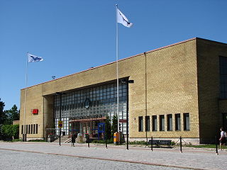
Turku Central Station is a railway station in the VII District of Turku, Finland. It has VR services to Helsinki and towards Joensuu. The station serves approximately a million passengers annually.

Pitkämäki is a district of the city of Turku, in Finland. It is located in the southeast of the city, and consists of several residential suburbs and industrial area. Pitkämäki is the only district in Turku to be divided among three different wards: the industrial area belongs to the City Centre ward, the high-density residential area of Suikkila to Kuninkoja, and the low-density residential area of Muhkuri to Naantalintie.

Iso-Heikkilä is a district of the city of Turku, in Finland. It is located to the west of the city centre, bordering on the city centre's VIII District.

Kurjenmäki is a district of the city of Turku, in Finland. It is located to the southeast of the city centre, bordering on the city centre's II and III districts, as well as Kupittaa. The Turku City Hospital is located in Kurjenmäki.

Vähäheikkilä is a district of the city of Turku, in Finland. It is located to the south of the city centre, between Martti and Puistomäki. Despite the district's name it has nothing to do with Iso-Heikkilä, which is located on the other side of the city centre.

Vätti is a district of the city of Turku, in Finland. It is located to the north of the city centre. The area consists mostly of parkland, but there is also a high-density residential area in the district as well as some low-density developments. There is also an old people's home in Vätti.

Katariina is a district in the Uittamo-Skanssi ward of the city of Turku, in Finland. It is located in the south of the city, and is mainly a low-density residential suburb. There is also a nature reserve in the area.

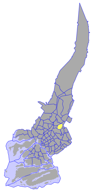
Pääskyvuori is a district in the Itäharju-Varissuo ward of the city of Turku, in Finland. It is located to the east of the city between Varissuo and Itäharju and is largely a low-density residential suburb. Pääskyvuori also includes the more densely built area of Laukkavuori. The name consists of the words pääsky, meaning 'swallow', and vuori, meaning 'mountain'. The former television tower located in the district is the tallest free-standing structure in the Turku area.


