
The States of South Sudan were created out of the three historic former provinces of Bahr el Ghazal (northwest), Equatoria (southern), and Greater Upper Nile (northeast). The states are further divided into 79 counties.

The Republic of South Sudan established relations with sovereign states and international organizations following independence on 9 July 2011. South Sudan's former ruling country of Sudan was the first state in the world to recognize South Sudan.

South Sudan, officially the Republic of South Sudan, is a landlocked country in eastern Central Africa. It is bordered by Ethiopia, Sudan, the Central African Republic, the Democratic Republic of the Congo, Uganda, and Kenya, and includes the vast swamp region of the Sudd, formed by the White Nile and known locally as the Bahr al Jabal, meaning "Mountain Sea". The population was 11,088,796 in 2023, and Juba is the capital and largest city. South Sudan gained independence from Sudan on 9 July 2011, making it the most recent sovereign state or country with widespread recognition as of 2024.

Raga County is a county in Western Bahr el Ghazal, South Sudan. It is the largest county in the nation. In Arabic, Raga County can be known as "Raja".

Akobo was a state in South Sudan that existed between 14 January 2017 and 22 February 2020.

Gogrial West County is an administrative county in the Warrap State, of South Sudan.

Cueibet County is an administrative area in Lakes State, South Sudan.
Rumbek North County is an administrative area (county) located in Lakes State, South Sudan. In August 2016, the former Rumbek North County had split to create Aloor County and Malueth County.
Rumbek East County is an administrative area (county) located in Lakes State, South Sudan. In August 2016, the former Rumbek East County had split to create Eastern Bhar Naam County and Western Bhar Naam County. Headquarter of Rumbek East is located at Thon-Aduel
Rumbek Center County is an administrative area (county) located in Lakes State, South Sudan. In August 2016, the former Rumbek Center County had split to create Amongping County, Malek County and Rumbek County.
Wulu County is an administrative area (county) located in Lakes State, South Sudan. In August 2016, the former larger Wulu County had split to create a newer smaller Wulu County and Barghel County.
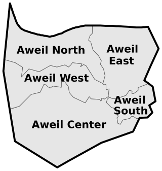
Aweil North County, is a county of Northern Bahr el Ghazal state, South Sudan.
Aweil Center County is an administrative area in Northern Bahr el Ghazal, South Sudan.

Tambura County is an administrative area in Western Equatoria, South Sudan.
Yambio County is an administrative state capital of Western Equatoria State, South Sudan.
Ezo County is an administrative area in Western Equatoria State, South Sudan.
Mvolo County is an administrative area in Western Equatoria State, South Sudan.
Mundri West County is a small administrative area in Western Equatoria, South Sudan.
Mundri East County is an administrative area in Western Equatoria, South Sudan.
Maridi County is an administrative area in Western Equatoria, South Sudan. It borders Mvolo County to the north-east, Mundri West County to the east and Ibba County to the west. It also borders Lakes State to the north-west, Central Equatoria State to the south-east and the Democratic Republic of Congo to the south-west. The major ethnic groups in Maridi County are Baka, Mundu, Avukaya, Zande, Moro Kodo, and Wetu.