
Pembina County is a county in the U.S. state of North Dakota. At the 2010 United States Census its population was 7,413. The county seat is Cavalier.

Kandahar is a hamlet in Rural Municipality of Big Quill No. 308, Saskatchewan, Canada. Listed as a designated place by Statistics Canada, the hamlet had a population of 20 in the Canada 2016 Census. Located on Highway 16 near Wynyard, Saskatchewan, Canada, named by Canadian Pacific Railway executives in the late 19th century for a British military victory in Kandahar, Afghanistan. The hamlet is too small to be enumerated on its own, so its population belongs to the Rural Municipality of Big Quill No. 308. It is located near the south shore of Big Quill Lake, the largest inland body of salt water in Canada.

Icelanders are a North Germanic ethnic group and nation who are native to the island country of Iceland and speak Icelandic.

Emerson is an unincorporated community recognized as a local urban district in south central Manitoba, Canada, located within the Municipality of Emerson – Franklin. It has a population of 655.
Icelandic Canadians are Canadian citizens of Icelandic ancestry or Iceland-born people who reside in Canada.

Morris is a small town in the Pembina Valley region of Manitoba, Canada, located 51 km south of Winnipeg and 42 km north of Emerson. Morris is home to 1,885 people (2016). Named after Alexander Morris, the second Lieutenant Governor of Manitoba.
Sigtryggur Jonasson was a community leader and politician in Manitoba, Canada. He played a major part in establishing the Icelandic community in Manitoba. Jonasson served in the Legislative Assembly of Manitoba from 1896 to 1899 and again from 1907 to 1910, as a member of the Manitoba Liberal Party.

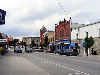
Kinmount is a village with a population of approximately 500, located on the Burnt River in Ontario, Canada. The village is apportioned by three municipalities, they are, City of Kawartha Lakes, Minden Hills and Trent Lakes. The village's hinterland covers large sections of both Haliburton and Peterborough counties for which it is a shopping and cultural centre. Prior to the formation of the City of Kawartha Lakes, Kinmount was the seat of Somerville Township.

Arborg is a town located 103 kilometres north of Winnipeg, at the junction of Manitoba Highways 7 and 68, in the Interlake Region of Manitoba, Canada. The town is surrounded by the Municipality of Bifrost - Riverton and has a population of 1,222 as of the Canada 2016 Census.
Harriston is a community in the Town of Minto in Wellington County, Ontario, Canada. In 1999, Harriston was amalgamated with the communities of Palmerston, Clifford, and Minto Township to form the Town of Minto. Harriston is located at the headwaters of the Maitland River, and has several shops, restaurants, a library, an art gallery and cultural centre.
Icelandic Americans are Americans of Icelandic descent or Iceland-born people who reside in the United States. Icelandic immigrants came to the United States primarily in the period 1873–1905 and after World War II. There are more than 40,000 Icelandic Americans according to the 2000 U.S. census, and most live in the Upper Midwest. The United States is home to the second largest Icelandic diaspora community in the world after Canada.

The United Townships of Dysart, Dudley, Harcourt, Guilford, Harburn, Bruton, Havelock, Eyre and Clyde, commonly known as the Municipality of Dysart et al, is a municipality in Haliburton County in Central Ontario, Canada. The original townships were of the Canadian Land and Emigration Company. At 61 letters or 68 non-space characters, the municipality has the longest name of any place in Canada.

The Council of Keewatin was an unelected legislative body and territorial government for the now-defunct District of Keewatin in Canada. The District of Keewatin was created by the passage of the Keewatin Act on October 7, 1876 from a portion of Canada's North West Territories. Lieutenant Governor Alexander Morris convinced the government that the new territorial government of the North West Territories would be unable to effectively administer land to the north and east of Manitoba. Shortly after the District of Keewatin was formed a large group of Icelanders arrived, infected with smallpox which quickly spread to the indigenous First Nation population. The Government of Canada allowed the Council to be formed for the purpose of containing the smallpox epidemic. The Council also administered Indian treaty claims, immigrant land claims, Hudson's Bay Company trading post concerns as well as policing and health care. The Council lasted from November 25, 1876, until April 16, 1877, after which control of the territory was returned under federal jurisdiction.

The history of Manitoba covers the period from the arrival of Paleo-Indians thousands of years ago to the present day. Prior to European colonization, the lands encompassing present-day Manitoba were inhabited for millennia by several First Nations. European fur traders in the area during the late-17th century, with the French under Pierre Gaultier de Varennes, sieur de La Vérendrye setting up several trading post forts in the area. In 1670, Britain declared sovereignty over the watershed of Hudson's Bay, known as Rupert's Land; with the Hudson's Bay Company granted a commercial monopoly over the territory.
New Iceland is the name of a region on Lake Winnipeg in the Canadian province Manitoba which was named for settlers from Iceland. It was settled in 1875.
The Victoria Railway is a historic 55.52-mile (89.35 km) long Canadian railway that operated in Central Ontario. Construction under Chief Engineer James Ross began in 1874 from Lindsay, Ontario, with authority to build through Victoria County to Haliburton, Ontario, to which it opened on November 24, 1878. The line is best known as having been built by a large group of Icelandic immigrants, who found the Kinmount winters too rough, and so they all moved to Gimli, Manitoba. The line became part of the Midland Railway of Canada and then later part of the Canadian National Railways. The line was abandoned completely by the early 1990s.

Canada – Iceland relations refer to international relations between Canada and Iceland. Both nations are members of the Arctic Council, NATO, Organisation for Economic Co-operation and Development and the World Trade Organization.
Fisher River (Ochekwi-Sipi) is a Cree First Nations reserve located approximately 193 km north of Manitoba's capital city, Winnipeg. The Fisher River Cree Nation is composed of two reserves; Fisher River 44 and Fisher River 44A. The reserve population is 1945, the off reserve population is 1934 for a total of 3879 band members as of June 2017. Fisher River is 15,614 acres.

Gimli is an unincorporated community in the Rural Municipality of Gimli on the west side of Lake Winnipeg in Manitoba. The community's first European settlers were Icelanders who were part of the New Iceland settlement in Manitoba. The community maintains a strong connection to Iceland and Icelandic culture today, including the annual Icelandic Festival. It was incorporated as a village on March 6, 1908, and held town status between December 31, 1946, and January 1, 2003, when it amalgamated with the RM of Gimli. Census Canada now recognizes the community as a population centre for census purposes. The 2016 Canadian census recorded a population of 2,246 in the population centre of Gimli.
Spanish Fork, Utah was the first Icelandic settlement in the United States. Icelandic people settled there primarily from 1855-1914. Icelandic influence in Spanish Fork is still prevalent today. This is primarily visible in the Icelandic Monument found in Spanish Fork, as well as the festivals that have been held over the years to pay tribute to the Icelandic people who helped establish Spanish Fork.
