
Lake Barcroft is a census-designated place (CDP) in Fairfax County, Virginia, United States. The population was 9,558 at the 2010 census. It is also the name of the privately owned lake—part of the Cameron Run Watershed—around which this population is located. The lake is named for Dr. John W. Barcroft, who owned and operated a mill on Holmes Run during the mid-19th century.
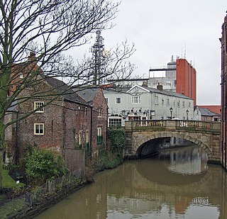
The River Foss is in North Yorkshire, England. It is a tributary of the River Ouse. It rises in the Foss Crooks Woods near Oulston Reservoir close to the village of Yearsley and runs south through the Vale of York to the Ouse in the centre of York. The name most likely comes from the Latin word Fossa, meaning ditch. It is mentioned in the Domesday Book. The York district was settled by Norwegian and Danish people, so parts of the place names could be old Norse. Referring to the etymological dictionary "Etymologisk ordbog", ISBN 82-905-2016-6 deals with the common Danish and Norwegian languages – roots of words and the original meaning. The old Norse word Fos (waterfall) means impetuous. The River Foss was dammed, and even though the elevation to the River Ouse is small, a waterfall was formed. This may have led to the name Fos which became Foss.
The Upper Derwent Valley is an area of the Peak District National Park in England. It largely lies in Derbyshire, but its north eastern area lies in Sheffield, South Yorkshire. Its most significant features are the Derwent Dams, Ladybower, Derwent and Howden, which form Ladybower Reservoir, Derwent Reservoir and Howden Reservoir respectively.

Rayon, also called viscose and commercialised in some countries as sabra silk or cactus silk, is a semi-synthetic fiber, made from natural sources of regenerated cellulose, such as wood and related agricultural products. It has the same molecular structure as cellulose. Many types and grades of viscose fibers and films exist. Some imitate the feel and texture of natural fibers such as silk, wool, cotton, and linen. The types that resemble silk are often called artificial silk. It can be woven or knit to make textiles for clothing and other purposes.
The River Loxley is a river in the City of Sheffield, South Yorkshire, England. Its source is a series of streams which rise some 10 miles (16 km) to the north-west of Sheffield on Bradfield Moors, flowing through Bradfield Dale to converge at Low Bradfield. It flows easterly through Damflask Reservoir and is joined by Storrs Brook at Storrs, near Stannington, and the River Rivelin at Malin Bridge, before flowing into the River Don at Owlerton, in Hillsborough. The Loxley valley provided the initial course of the Great Sheffield Flood, which happened after the Dale Dyke Dam collapsed shortly before its completion in March 1864.
The South Fork Dam was an earthenwork dam forming Lake Conemaugh, an artificial body of water near South Fork, Pennsylvania, United States. On May 31, 1889, the South Fork Dam failed catastrophically and 20 million tons of water from Lake Conemaugh burst through and raced 14 miles (23 km) downstream, causing the Johnstown Flood.

The textile industry is primarily concerned with the design, production and distribution of textiles: yarn, cloth and clothing. The raw material may be natural, or synthetic using products of the chemical industry.

The Dnieper Hydroelectric Station, also known as the Dnipro Dam, is a hydroelectric power station in the city of Zaporizhzhia, Ukraine. Operated by Ukrhydroenergo, it is the fifth and largest station in the Dnieper reservoir cascade, a series of hydroelectric stations on the Dnieper river that supply power to the Donets–Kryvyi Rih industrial region. Its dam has a length of 800 metres (2,600 ft), a height of 61 metres (200 ft), and a flow rate of 38.7 metres (127 ft) per second.
Courtaulds was a United Kingdom-based manufacturer of fabric, clothing, artificial fibres, and chemicals. It was established in 1794 and became the world's leading man-made fibre production company before being broken up in 1990 into Courtaulds plc and Courtaulds Textiles Ltd.

Westhoughton Mill or Rowe and Dunscough's Mill, in Mill Street in Westhoughton, near Bolton in the historic English county of Lancashire, was the site of a Luddite arson attack in 1812. The mill was built in 1804 by Richard Johnson Lockett, a Macclesfield man who lived at Westhoughton Hall. He leased the mill to Thomas Rowe of Manchester in 1808.

Dale Dike Reservoir or Dale Dyke Reservoir is a reservoir in the north-east Peak District, in the City of Sheffield, South Yorkshire, England, a mile (1.6 km) west of Bradfield and eight miles (13 km) from the centre of Sheffield, on the Dale Dike, a tributary of the River Loxley.
Toddbrook Reservoir, a feeder for the Peak Forest Canal, opened in 1838. It is above the town of Whaley Bridge in the High Peak area of Derbyshire, England. The reservoir is a Site of Special Scientific Interest (SSSI) providing habitats for herons, ducks and other animals and fish, while rare mosses and liverworts grow on its shores, particularly short-lived species that grow on seasonally exposed mud. The reservoir is used for sailing and angling. The Peak District Boundary Walk runs around the eastern end of the reservoir. The reservoir is owned by the Canal & River Trust and, like the nearby Combs Reservoir, is a feeder reservoir for the Peak Forest Canal. The feeder runs through Whaley Bridge, and with the Combs feed enters the canal system in a pool close to the transhipment shed at the Whaley Bridge canal basin.
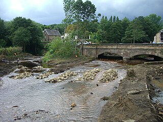
The Holmfirth floods were a number of instances when severe flooding had occurred in the Holme Valley, West Yorkshire, England affecting Holmfirth and other settlements in the valley. The earliest record dates from 1738 and the latest from 1944. The most severe flood occurred early on the morning of 5 February 1852, when the embankment of the Bilberry reservoir collapsed causing the deaths of 81 people. It is recorded as the 23rd most serious, worldwide, in terms of loss of life from floods and landslides in human history.

The environmental impact of reservoirs comes under ever-increasing scrutiny as the global demand for water and energy increases and the number and size of reservoirs increases.

Ulley Reservoir is a reservoir a few hundred yards to the west and downhill of the village of Ulley, 4 miles (6.4 km) south of Rotherham, South Yorkshire, England. It is 2.5 miles (4 km) away from junction 33 of the M1 motorway.

Cowling is a village, electoral division and civil parish in the Craven district of North Yorkshire, England. It is situated on the borders with the adjacent counties of West Yorkshire, and Lancashire.

Atlas Mill was a cotton spinning mill in the Waterloo district of Ashton-under-Lyne, Greater Manchester, in England. It was built between 1898 and 1900 for the Ashton Syndicate by Sydney Stott of Oldham. It was last mill in Ashton to cease spinning. It was spinning artificial fibres in 1987, it closed in 1990 and was demolished in 1994; the site is now a housing estate.
MV Putney Hill was a cargo ship completed by William Doxford & Sons Ltd in Sunderland in 1940. She was owned by Putney Hill Steamships Co Ltd and managed by Counties Ship Management Co Ltd of London (CSM), both of which were offshoots of the Rethymnis & Kulukundis shipbroking company. Putney Hill was a sister ship of MV Tower Grange, which Doxford built in the same year for another CSM company, Tower Steamships Co Ltd.
Testalinden Creek is a watercourse that flows east into the Okanagan River, south of the Okanagan town of Oliver, British Columbia. The Testalinden Dam was at the headwaters of this creek prior to the dam's failure in June 2010.
