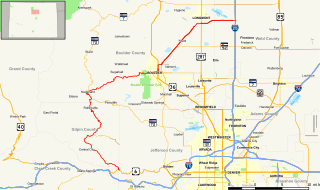
State Highway 7 is an 81.64 miles (131.39 km) long state highway in the U.S. state of Colorado. It is located in the north-central portion of the state, traversing the mountains on the east of the continental divide south of Estes Park as well as portions of the Colorado Piedmont north of Denver. The northwestern segment of the highway is part of the Peak-to-Peak Scenic Byway and furnishes an access route to Estes Park, Colorado and Rocky Mountain National Park. In its southeast portion it skirts the northern end of the Denver Metropolitan Area, providing an access route connecting Boulder, Lafayette and Brighton with Interstate 25 and Interstate 76.
State Highway 5 (SH 5) is a 14.89-mile-long (23.96 km) state highway in the U.S. state of Colorado and is the highest paved road in North America. However, this is not a through highway; it is simply a scenic spur route to the summit of Mount Evans, altitude 14,264 feet. The southern terminus of State Highway 5 is at a parking lot somewhat below the actual summit, and the northern terminus is at SH 103 at Echo Lake.
State Highway 8 (SH 8) is an 8.68-mile (13.97 km) long state highway in the U.S. state of Colorado. SH 8's western terminus is at U.S. Route 285 (US 285) in Morrison, and the eastern terminus is at SH 121 in Lakewood.

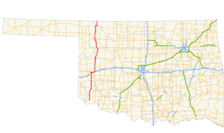
State Highway 34 is a state highway in the U.S. state of Oklahoma. It runs for 188.3 miles (303.0 km) south-to-north in the western part of the state. The highway begins northeast of Eldorado, in the southwest corner of the state, and extends north to the Kansas state line between Woodward and Coldwater, Kansas.

State Highway 135 (SH 135) is a 27.48-mile-long (44.22 km) state highway in the U.S. state of Colorado. SH 135's southern terminus is at U.S. Route 50 (US 50) in Gunnison, and the northern terminus is at 6th Street in Crested Butte. It is the primary connection between Crested Butte and the outside world and is the only paved road leading to Crested Butte.
State Highway 103 in the U.S. state of Colorado runs from Interstate 70 (I-70), U.S. Route 6 and US 40 at Idaho Springs to county roads 151 and 103 at Squaw Pass. The 13 miles (19 km) from Idaho Springs to SH 5 forms about half of the Mount Evans Scenic Byway.
State Highway 8 is an Idaho state highway in Latah and Clearwater counties, running from the Washington state line in Moscow to Elk River. It is 53.589 miles (86.24 km) in length, and runs primarily east–west.
Idaho State Highway 69 (SH-69) is a short 8.012-mile-long (12.894 km) state highway in the U.S. state of Idaho. It runs from Kuna to Interstate 84 (I-84) in Meridian.
Idaho State Highway 28 (SH-28) is a 135.645-mile-long (218.299 km) state highway in Idaho which runs from Salmon, Idaho to Interstate 15 (I-15) near the Continental Divide.
Idaho State Highway 7 (SH-7) is a state highway in Clearwater County, Idaho running from the Lewis County line through Orofino. It is 16.5 miles (26.6 km) long and runs north-south.
Idaho State Highway 13 is a state highway located entirely within Idaho County in North Central Idaho. SH 13 is 26 miles (42 km) long and runs from U.S. Route 95 in Grangeville to US-12 in Kooskia. In addition to those cities, SH-13 also serves the city of Stites and the community of Harpster. SH-13 has one special route, Business Loop 13 in Kooskia.
Idaho State Highway 39 (SH-39) is a 52.924-mile-long (85.173 km) state highway located in Power and Bingham counties in Idaho. SH-39 runs from its southern terminus at Interstate 86 (I-86) in American Falls to its northern terminus at U.S. Route 26 (US-26) in Blackfoot. Between the two cities, it passes through the city of Aberdeen and the communities of Springfield and Pingree.
Idaho State Highway 43 (SH-43) is a 3.868-mile-long (6.225 km) state highway located in Bonneville County, Idaho. SH-43 runs from its southern terminus at U.S. Route 26 (US-26) in Beachs Corner to its northern terminus at US-20 in Ucon. The highway is maintained by the Idaho Transportation Department.

State Highway 170 is a state highway in Colorado that connects Eldorado Springs and Superior. SH 170's western terminus is at Eldorado Canyon State Park, and the eastern terminus is at U.S. Route 36 (US 36) in Superior.

State Highway 119 is a 63.7-mile-long (102.5 km) state highway in north central Colorado. It extends in a southwest to northeast direction, from a junction with U.S. Route 6 in Clear Creek Canyon between Golden and Idaho Springs to a junction with Interstate 25 (I-25) east of Longmont. The southwest portion of the road is a scenic mountain drive providing dramatic vistas of the Front Range, while the northeast portion is a busy interurban thoroughfare. The city of Boulder separates these two vastly different sections of SH 119.
Idaho State Highway 38 (SH-38) is a state highway that spans 23.438 miles (37.720 km) east-west in Oneida County in the southeast Idaho, United States from Holbrook east to Interstate 15 (I-15) in Malad City.
State Highway 19 is a state highway in Idaho from the Oregon state line to Interstate 84 Business in Caldwell. SH 19 is signed as an east-west highway.
State Highway 29 (SH-29) is a 13.614-mile-long (21.910 km) state highway in Idaho. SH-29 runs from SH-28 in Leadore to Montana Secondary Highway 324 (S-324) at the Montana state line at Bannock Pass.
State Highway 37 (SH-37) is a state highway in Power County in southern Idaho, United States that spans 31.231 miles (50.261 km) north-south from the Oneida–Power county line to Interstate 86 (I-86).
State Highway 128 (SH-128) is a 2.198-mile-long (3.537 km) state highway in the U.S. state of Idaho, serving the city of Lewiston in Nez Perce County. The highway travels east along the Clearwater River within Lewiston from Washington State Route 128 (SR 128) to U.S. Route 12 (US-12).


