Related Research Articles
Acre is a state located in the west of the North Region of Brazil and the Amazonia Legal. Located in the westernmost part of the country, at a two-hour time difference from Brasília, Acre is bordered clockwise by the Brazilian states of Amazonas and Rondônia to the north and east, the Bolivian department of Pando to the southeast, and the Peruvian regions of Madre de Dios, Ucayali and Loreto to the south and west. The state, which has 0.42% of the Brazilian population, generates 0.2% of the Brazilian GDP.
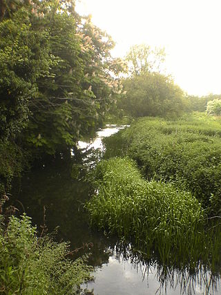
The River Rib originates near the East Hertfordshire village of Therfield and runs parallel with the A10 through Chipping, Wyddial, Buntingford, Westmill, Braughing, Puckeridge and Standon, before dividing the villages of Thundridge and Wadesmill and continuing until it reaches its confluence with the River Lea near Hertford.

Açucena is a city in the Brazilian state of Minas Gerais. In 2020 its population was estimated to be 9,368.
Arrow Lakes Provincial Park is a provincial park in British Columbia, Canada.

The Afon Lledr is a river in north-west Wales and the second major tributary of the River Conwy. It is about 10 miles or 16 km long, and flows in a generally easterly direction.

Apetina, also known as Pïlëuwimë or Puleowime, is a village in the South Eastern jungle area of Suriname within the Tapanahony resort in the Sipaliwini District. It is located at 3°30′N55°04′W in the jungle on the small hills along the river Tapanahoni. Nearby points include Tebu Mountain, at around 347 m (1,138 ft) in height, and the Man Gandafutu waterfall. The majority of Apetina's population is the Wayana people. These Indians mostly originate from Brazil and once have fled because of tribal warfare. There also is primary school and an airstrip located near the Indian village of Apetina.

Santo Antônio do Sudoeste is a municipality in the state of Paraná, Brazil with a population of 20,261 inhabitants. It is on the border between Argentina and Brazil, opposite the Argentine city of San Antonio, Misiones. The San Antonio River separates the two cities.

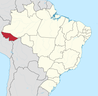
Santa Rosa do Purus is a municipality in the Brazilian state of Acre.

Belterra is a municipal seat and rubber plantation site some 40 km (25 mi) south of the Brazilian city of Santarém in the Northern federal state of Pará, at the edge of the Planalto at 165 m (541 ft) above sea level.
Jequitinhonha is a Brazilian municipality located in the northeast of the state of Minas Gerais.

Pai Pedro is a municipality in the northeast of the Brazilian state of Minas Gerais. As of 2020 the population was 6,094 in a total area of 785 km2 (303 sq mi). The elevation is 520 meters (1,710 ft). It became a municipality in 1997. The postal code (CEP) is 39517-000.

The Republic of Acre or the Independent State of Acre were the names of a series of separatist governments in then Bolivia's Acre region between 1899 and 1903. The region was eventually annexed by Brazil in 1903 and is now the State of Acre.
Chambuiaco River is a river of Acre state in western Brazil.
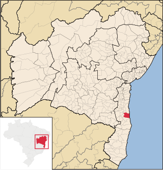
Una is a city in Bahia, Brazil. Its population in 2020 was 18,544 inhabitants. It is located about 36 mi (58 km) south from Ilheus.

Vitorino Freire is a municipality in the state of Maranhão in the Northeast region of Brazil.

Pettus Glacier is a narrow deeply entrenched glacier 9 nautical miles (17 km) long, which flows north from Ebony Wall into Gavin Ice Piedmont between Poynter Hill and Tinsel Dome, Trinity Peninsula. Named by United Kingdom Antarctic Place-Names Committee (UK-APC) for Robert N. Pettus, aircraft pilot with Falkland Islands and Dependencies Aerial Survey Expedition (FIDASE), 1956–57.
Navanagar is the new planned city created because of submergence of parts of old Bagalkot city, Karnataka, India.
The Aroa is a river of Papua New Guinea. It flows into the sea in the northern end of Redscar Bay, about 11 miles from Cape Suckling, to the north-west of Port Moresby. 1.75 metres to the south are the Kekeni Rocks, reaching a height of 21 metres (69 ft)
References
Coordinates: 9°48′S70°04′W / 9.800°S 70.067°W