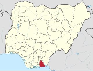
Akwa Ibom State is a state in the South-South geopolitical zone of Nigeria, bordered on the east by Cross River State, on the west by Rivers State and Abia State, and on the south by the Atlantic Ocean. The state takes its name from the Qua Iboe River which bisects the state before flowing into the Bight of Bonny. Akwa Ibom was split from Cross River State in 1987 with its capital Uyo and with 31 local government areas.

The Eastern Region was an administrative region in Nigeria, dating back originally from the division of the colony Southern Nigeria in 1954. Its first capital was Calabar. The capital was later moved to Enugu and the second capital was Umuahia. The region was officially divided in 1967 into three new states, the East-Central State, Rivers State and South-Eastern State. East-Central State had its capital at Enugu, which is now part of Enugu State.
Ikot Ekpene, also known as The Raffia City, is a historic town in south-southern state of Akwa Ibom. It is the political and cultural capital of the Annang ethnic group in Nigeria. The town is located on the A342 highway that parallels the coast, between Calabar to the south east and Aba to the west, with the state capital, Uyo, on this road just to the east. Umuahia is the next major town to the north.
Opobo is a community in Rivers State, in the South South region of Nigeria. The kingdom was founded in 1870 by Jubo Jubogha, popularly known as JaJa, an Igbo man who was an apprentice under Annie Pepple house in Bonny, grew to become a Chief and eventually wanted to be King in Bonny. He was followed and supported by Chiefs from 14 major houses that left Bonny to establish Opobo. The native language of Opobo is the Ibani language that is spoken in Bonny also, although I’m recent years their Igbo-creole known as Ubani as taken became the primary tongue
Eket is one of the 31 local government areas in Akwa Ibom State, Nigeria. The name Eket or Ekid also refers to the indigenous ethnic group of the region and to their language. The Eket people use the endonym Ekid for themselves and their language, but Europeans spell and pronounce the name as "Eket".
Oruk Anam is a Local Government Area located in the southwestern part of Akwa Ibom State, Nigeria. It may be ranked as the largest LGA in Akwa-ibom due to its land popularity. Its headquarters are located in the town of Ikot Ibritam. It is one of the eight Annang-speaking local government areas.
Essien Udim is one of the Annang speaking Local Government Areas in Akwa Ibom State, Nigeria.
Etim Ekpo is a town and Local Government Area in Akwa Ibom State, Nigeria.
The Nkoro tribe' of the Ijaw people lives in southeastern Rivers State, Nigeria. Nkoro settlements include: Nkoro, Ayama, Dema, The cultural traditions have been influenced by its proximity to the Andoni, the Bonny. The Nkoro dialect is a dialect of the Ijaw language.
Ibiono-Ibom is a Local Government Area of Akwa Ibom State in the south-south region of Nigeria. It has its administrative headquarters at Oko Ita.

Ikot Abasi is located in the south west corner of Akwa Ibom State, Nigeria. It is bounded by Oruk Anam Local Government Area in the north, Mkpat Enin and Eastern Obolo Local Government Areas in the east and the Atlantic Ocean in the south. The Imo River forms the natural boundary in the west separating it from Rivers State.
Mbo is located in the South Eastern part of Nigeria and is a Local Government Area in Akwa Ibom State. Following the local government creation exercise of the federal government in 1989 Mbo Local Government Area was carved out of Oron Division same year.
Mkpat-Enin is located in the South South region of Nigeria and is a town and a Local Government Area (LGA) of Akwa Ibom State. It sits at an altitude of approximately 185 metres (607 ft) above sea level.
Nsit Atai Local government area was created in the year 1996 with its capital at Odot by the government of Gen. Sani Abacha. It has an area of out of an about 17,000 square kilometers, with 62 villages.

Obot-Akara is in the south of Nigeria and is a Local Government Area of Akwa Ibom State.
Uruan is located in the south of Nigeria and is a Local Government Area of the Akwa Ibom State.
Ikot Ukpong is a village in Okon development ward II of Eket local government area, Akwa Ibom State, Nigeria. Ikot Ukpong means "Family of Ukpong" or "People of Ukpong". Ikot Ukpong is made up of different settler-families and descendants of the founder of the village. The deity of Ikot Ukpong was called "Ukpong Idem", meaning "spirit body". Other deities traditionally recognised by the village were Ekpo (ancestors) and Ndem Ikpa Isong. Their primary language is Ibibio despite their affinity with Ekid people of Eket. Ikot Ukpong is occupied by the Ibibio people.
Asanga also known as Nung Ikot Asanga is a town located in the Nung Ikot Clan, Oruk Anam local government area of Akwa Ibom State, the southern region of Nigeria.
Inen popularly known as Inen Ekeffe Is one of the nine Clans in Oruk Anam local government area. And it is numbered as the one among the nine Administrative Areas of the Oruk Anam with its people speaking the Annang language in Akwa Ibom State the southern region of Nigeria.
Ikot Inuen is a town in southern Abak/Midim Clan in Oruk Anam LGA of Akwa Ibom State. It is bounded in the south by Edemaya Clan of Ikot Abasi. It is located on Nigeria's East-West road that links Port Harcourt to Ikot Abasi. It marks the linguistic transition zone between the Annang and Ibibio speaking ethnic groups of Akwa Ibom State. Being part of the Anam political unit of Oruk Anam LGA, Ikot Inuen was part of the Opobo Division from the precolonial era until 1967, when it was moved to the newly created South Eastern State, which was later renamed Cross River State. Ikot Inuen is among the communities that is climatically influenced by Imo River that separates Rivers State from Akwa Ibom State of Nigeria. The area is rich in arable farmland, which makes farming the occupation of about half of the populace. Others are involved in petty trading, artisanship, and civil service. The area is rich in crude oil deposits, as evidenced in the corked oil well belonging to Shell Petroleum at Efut Idim Etok, also known as Idim aShell. In academics, the area has a public Primary School, The St Jude's Catholic School, and a public Secondary School, The Community Secondary School. The Ukoessien Central Market boasts commercial activities in the area. Apart from the first church, the St Jude's Catholic Church, established in 1919, other churches in the community include the Methodist Church, the Christ Army Church, the Samuel Spiritual Church, the Apostolic Church, the Mount Zion Mission, the Assemblies of God Church, the Deeper Life Bible Church, the Wings of Redemption Ministries and the Redeemed Christian Church of God.
