
São Tomé and Príncipe is a small nation composed of an archipelago located in the Gulf of Guinea of equatorial Atlantic Ocean. The nation's main islands are São Tomé Island and Príncipe Island, for which the country is named. These are located about 300 and 250 kilometres, respectively, off the northwest coast of Gabon in Central Africa. The nation's geographic coordinates are a latitude of 1°00′N and a longitude of 7°00′E.
Transport in São Tomé and Príncipe relies primarily on road infrastructure for local needs and airports and sea travel for international needs. São Tomé and Príncipe does not have railways.
Príncipe is the smaller, northern major island of the country of São Tomé and Príncipe lying off the west coast of Africa in the Gulf of Guinea. It has an area of 136 square kilometres (53 sq mi) and a population of 7,324 (2012). The island is a heavily eroded volcano speculated to be over three million years old, surrounded by smaller islands including Ilheu Bom Bom, Ilhéu Caroço, Tinhosa Grande and Tinhosa Pequena. Part of the Cameroon Line archipelago, Príncipe rises in the south to 947 metres at Pico do Príncipe. The island is the main constituent of the Autonomous Region of Príncipe, established in 1995, and of the coterminous district of Pagué.

Caué is a district of São Tomé and Príncipe, on São Tomé Island. Covering 267 km2 (103 sq mi), it is the largest of the nation's seven districts in terms of area. In population it is the smallest, with 6,031 residents (2012). The district seat is São João dos Angolares. It is divided into the two statistical subdistricts São João dos Angolares and Malanza.

Lembá is a district of São Tomé and Príncipe, on São Tomé Island. Its area is 229.5 km2 (89 sq mi), and its population is 14,652 (2012). The district seat is Neves. It is divided into the two statistical subdistricts Neves and Santa Catarina.

The Barlavento Islands is the northern island group of the Cape Verde archipelago. It can be divided into two sub-groups:

Ilhéu das Rolas is an islet in the African island nation of São Tomé and Príncipe. The island lies on the equator, off the southern tip of São Tomé Island, separated by Canal das Rolas. Its maximum elevation is 96 m. Its population is 76. It is part of the Caué District. Access is only by ferry departing from Ponta Baleia on São Tomé Island. There is a lighthouse on the islet, built in 1929. Its focal height is 106 meters and its range is 12 nmi. The island is home to a small resort, the Pestana Equador.

Santana is a town on the eastern coast of São Tomé Island, which is part of the island nation of São Tomé and Príncipe. It is the seat of Cantagalo District. The population of Santana with the adjacent settlements Cidade Alta, Cova Água, Gomes, Nova Olinda, Picão Flor, Praia Messias Alves, Riboque Santana and Zandrigo is 10,290 (2012).2012 detailed census São Tomé e Príncipe, Instituto Nacional de Estatística</ref> Santana lies 9 km south of the capital São Tomé and 17 km northeast of São João dos Angolares. The islet Ilhéu de Santana lies about 1 km off-shore, 2.5 km southeast of Santana.
Ilhéu Bom Bom is an island in the Gulf of Guinea. The islet is located near the north coast of the island of Príncipe, one of the main islands of São Tomé and Príncipe and is almost completely forested. Its population is 15. There is a tourist resort near the island. There is a lighthouse on the island built in 1997. Its focal height is 64 meters and its range is 12 nmi.

Ilhéu das Cabras is an uninhabited island in the Gulf of Guinea. It is one of the smaller islands of São Tomé and Príncipe. The islet is located about 2 km off the northeast coast of the island of São Tomé, 8 km north of the city centre of São Tomé. The islet consists of two hills, about 90 metres high. There is a lighthouse on the northeastern summit, built in 1890; its focal height 97 metres and its range is 12 nmi. The islet was mentioned as "Mooro Caebres" in the 1665 map by Johannes Vingboons.
Ilhéu Caroço is an uninhabited islet in the Gulf of Guinea, part of São Tomé and Príncipe. The islet is located southeast of the island of Príncipe, about 3 km off the coast. Its area is about 0.4 km². The islet is steep, rocky and wooded, and rises to 305 metres elevation.
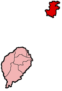
The Autonomous Region of Príncipe is an administrative division of the Republic of São Tomé and Príncipe. Established on 29 April 1995, it covers the island of Príncipe and a number of small uninhabited islands around it, with an area of 142 km2 (55 sq mi) in total. As defined by the constitution of São Tomé and Príncipe, the Autonomous Region of Príncipe has a Regional Assembly and a Regional Government. Its population was 7,324 at the 2012 census. It consists of a single district: Pagué. Its seat is the town Santo António.
Ilhéu de Santana is an uninhabited island in the Gulf of Guinea and is one of the smaller islands of São Tomé and Príncipe. The islet is located 0.7 nmi (1.3 km) off the east coast of the island of São Tomé near the town of Santana in Cantagalo District. It is 50 metres high. The islet was mentioned in the 1616 map by Jodocus Hondius as I. de S. Anne.
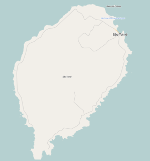
Micoló is a seaside town in Lobata District in the northern part of São Tomé Island in São Tomé and Príncipe. Its population is 1404. It is situated near the mouth of the river Rio do Ouro. The islet Ilhéu das Cabras lies about 2.5 km to the east. Micoló lies 4 km northeast of Conde and 9 km northwest of the city centre of the capital São Tomé.
Ilhéu Quixibá is an uninhabited islet in the Gulf of Guinea and is one of the smaller islands of São Tomé and Príncipe. The islet lies 0.3 km off the southeast coast of the island of São Tomé.
Ilhéu Gabado is an uninhabited islet in the Gulf of Guinea and is one of the smaller islands of São Tomé and Príncipe. The islet lies 0.4 km off the southwest coast of the island of São Tomé. Due north is another islet, Ilhéu de São Miguel.
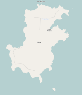
Ilhéu dos Mosteiros is an uninhabited islet in the Gulf of Guinea, part of São Tomé and Príncipe. It lies about 0.8 km off the northeast coast of the island of Príncipe. It is 20 metres high. Since 2012, the islet forms a part of Island of Príncipe Biosphere Reserve.


