
Saarland is a state of Germany in the west of the country. With an area of 2,570 km2 (990 sq mi) and population of 995,600 in 2015, it is the smallest German state in both area and population apart from the city-states of Berlin, Bremen, and Hamburg. Saarbrücken is the state capital and largest city; other cities include Neunkirchen and Saarlouis. Saarland is mainly surrounded by the department of Moselle in France to the west and south and the neighboring state of Rhineland-Palatinate in Germany to the north and east; it also shares a small border about 8 kilometres long with the canton of Remich in Luxembourg to the northwest.

Saarbrücken is the capital and largest city of the state of Saarland, Germany. Saarbrücken is Saarland's administrative, commercial and cultural centre and is next to the French border.
The Regionalverband Saarbrücken is a Kommunalverband besonderer Art, an integration of a district (Kreis) and a district-free town. It is located in the south of the Saarland, Germany. Neighboring districts are Saarlouis, Neunkirchen, Saar-Pfalz, and Forbach-Boulay-Moselle and Sarreguemines in the French département Moselle.
Sankt Wendel is a Kreis (district) in the north of the Saarland, Germany. Neighboring districts are Trier-Saarburg, Birkenfeld, Kusel, Neunkirchen, Saarlouis, and Merzig-Wadern.
Kusel is a district (Kreis) in the south of Rhineland-Palatinate, Germany. Neighboring districts are Birkenfeld, Bad Kreuznach, Donnersbergkreis, Kaiserslautern, Saarpfalz and Sankt Wendel.
Trier-Saarburg is a district in the west of Rhineland-Palatinate, Germany. Neighboring districts are Bitburg-Prüm, Bernkastel-Wittlich, Birkenfeld, Sankt Wendel (Saarland), and Merzig-Wadern (Saarland). To the west it borders Luxembourg. The district-free city Trier is completely surrounded by the district.
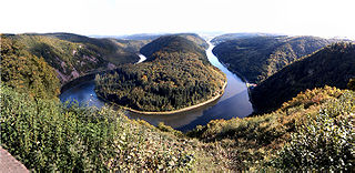
The Saar is a river in northeastern France and western Germany, and a right tributary of the Moselle. It rises in the Vosges mountains on the border of Alsace and Lorraine and flows northwards into the Moselle near Trier. It has two headstreams, that both start near Mont Donon, the highest peak of the northern Vosges. After 246 kilometres (153 mi) the Saar flows into the Moselle at Konz (Rhineland-Palatinate) between Trier and the Luxembourg border. It has a catchment area of 7,431 square kilometres (2,869 sq mi).

The Saarland national football team was the association football team representing the Saar Protectorate in international football from 1950 to 1956 during the French occupation following World War II. As France opposed the inclusion of the Saarland in the Federal Republic of Germany until 1956, they administered it separately from Germany as the Saar Protectorate.
The Saar Protectorate officially Saarland was a short-lived protectorate (1946–1957) partitioned from Germany after its defeat in World War II; it was administered by the French Fourth Republic. On rejoining the Federal Republic of Germany in 1957, it became the smallest "federal state" (Bundesland), the Saarland, not counting the "city states" of West Berlin, Hamburg, and Bremen. It is named after the Saar River.

Saarländischer Rundfunk is a public radio and television broadcaster serving the German state of Saarland. With headquarters in the Halberg Broadcasting House in Saarbrücken, SR is a member of the ARD consortium of German public-broadcasting organizations.

Saarland University is a modern research university located in Saarbrücken, the capital of the German state of Saarland. It was founded in 1948 in Homburg in co-operation with France and is organized in six faculties that cover all major fields of science. In 2007, the university was recognized as an excellence center for computer science in Germany.

The Glan is a river in southwestern Germany, right tributary of the Nahe. It is approximately 68 km long. It rises in the Saarland, northwest of Homburg. It flows generally north, through Rhineland-Palatinate, and empties into the Nahe near Odernheim am Glan, at Staudernheim, across the Nahe from Bad Sobernheim. Other towns along the Glan are Altenglan, Glan-Münchweiler, Lauterecken and Meisenheim.
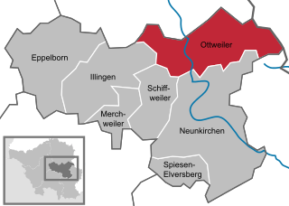
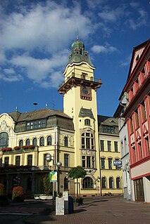
Ottweiler is a municipality, former seat of the district of Neunkirchen, in Saarland, Germany. It is situated on the river Blies, approx. 7 km north of Neunkirchen, and 25 km northeast of Saarbrücken.
Völklingen is a town in the district of Saarbrücken, in Saarland, Germany. It is situated on the river Saar, approx. 10 km west of Saarbrücken, and directly borders France.

Kleinblittersdorf is a village and a municipality in the district of Saarbrücken, in Saarland, Germany. It is situated on the river Saar, opposite Grosbliederstroff in France, approx. 10 km south of Saarbrücken.

Bexbach is a town in the Saarpfalz district, in Saarland, Germany. It is situated on the river Blies, approximatively 6 km east of Neunkirchen, and 25 km northeast of Saarbrücken. The Saarländisches Bergbaumuseum is located in the town.

The Territory of the Saar Basin was a region of Germany occupied and governed by the United Kingdom and France from 1920 to 1935 under a League of Nations mandate. It had its own flag : a blue, white, and black horizontal tricolour. The blue and white stood for Bavaria, and white and black for Prussia, out of whose lands the Saar Territory was formed. Initially, the occupation was under the auspices of the Treaty of Versailles. Its population in 1933 was 812,000, and its capital was Saarbrücken. The territory closely corresponds with the modern German state of Saarland, but was slightly smaller in area. After a plebiscite was held in 1935, it was returned to Germany.

The Saarland State Police is one of the smallest German Landespolizei forces with approx. 2,700 police officers. As in Hesse and Rheinland-Pfalz, the Saarland Police is abolishing the “green star” ranks meaning their new police officers start to work the road as Kommissars. This reform aims at making the police profession more attractive and improving promotion chances.

Wizernes is a northern French commune 4 miles (6.4 km) southwest of Saint-Omer on the banks of the river Aa at the D928 and D211 road junction. The commune is subdivided into townships. and is twinned with Ensdorf, Saarland, Germany.
