
The Saarland is a state of Germany in the south west of the country. With an area of 2,570 km2 (990 sq mi) and population of 990,509 in 2018, it is the smallest German state in area apart from the city-states of Berlin, Bremen, and Hamburg, and the smallest in population apart from Bremen. Saarbrücken is the state capital and largest city; other cities include Neunkirchen and Saarlouis. Saarland is mainly surrounded by the department of Moselle in France to the west and south and the neighboring state of Rhineland-Palatinate in Germany to the north and east; it also shares a small border about 8 kilometres long with the canton of Remich in Luxembourg to the northwest.

Saarbrücken is the capital and largest city of the state of Saarland, Germany. Saarbrücken is Saarland's administrative, commercial and cultural centre and is next to the French border.
Kusel is a district (Kreis) in the south of Rhineland-Palatinate, Germany. Neighboring districts are Birkenfeld, Bad Kreuznach, Donnersbergkreis, Kaiserslautern, Saarpfalz and Sankt Wendel.

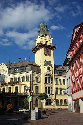
Saarlouis is a town in Saarland, Germany, capital of the district of Saarlouis. In 2020, the town had a population of 34,409. Saarlouis, as the name implies, is located on the river Saar. It was built as a fortress in 1680 and was named after Louis XIV of France.
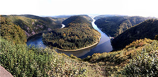
The Saar is a river in northeastern France and western Germany, and a right tributary of the Moselle. It rises in the Vosges mountains on the border of Alsace and Lorraine and flows northwards into the Moselle near Trier. It has two headstreams, that both start near Mont Donon, the highest peak of the northern Vosges. After 246 kilometres (153 mi) the Saar flows into the Moselle at Konz (Rhineland-Palatinate) between Trier and the Luxembourg border. It has a catchment area of 7,431 square kilometres (2,869 sq mi).
The Saar Protectorate officially Saarland was a French protectorate and a disputed territory separated from Germany. On joining the Federal Republic of Germany as a state of its in 1957, it became the smallest "federal state", the Saarland, not counting the "city states" of Berlin, Hamburg, and Bremen. It is named after the Saar River.
Kurówka is a river in South-East Poland, a right tributary of Vistula River. Its length is approximately 50 kilometres and its basin covers roughly 395.4 km2. Its source is located near the village of Piotrowice Wielkie and it joins Vistula in Puławy. Among the notable villages located along the river are Garbów, Markuszów, Kurów and Końskowola.

Stare Miasto is one of the five former administrative boroughs of Wrocław, Poland, comprising the oldest parts of the city. Its functions were largely taken over on 8 March 1990 by the Municipal Office of the newly established Wrocław Municipality. The name Stare Miasto remained in use, mainly for statistical and administrative purposes.

Saarländischer Rundfunk is a public radio and television broadcaster serving the German state of Saarland. With headquarters in the Halberg Broadcasting House in Saarbrücken, SR is a member of the ARD consortium of German public-broadcasting organizations.

Saarland University is a public research university located in Saarbrücken, the capital of the German state of Saarland. It was founded in 1948 in Homburg in co-operation with France and is organized in six faculties that cover all major fields of science. In 2007, the university was recognized as an excellence center for computer science in Germany.

The Glan is a river in southwestern Germany, right tributary of the Nahe. It is approximately 68 km long. It rises in the Saarland, northwest of Homburg. It flows generally north, through Rhineland-Palatinate, and empties into the Nahe near Odernheim am Glan, at Staudernheim, across the Nahe from Bad Sobernheim. Other towns along the Glan are Altenglan, Glan-Münchweiler, Lauterecken and Meisenheim.
Ottweiler is a municipality, former seat of the district of Neunkirchen, in Saarland, Germany. It is situated on the river Blies, approx. 7 km north of Neunkirchen, and 25 km northeast of Saarbrücken.
Völklingen is a town in the district of Saarbrücken, in Saarland, Germany. It is situated on the river Saar, approx. 10 km west of Saarbrücken, and directly borders France.

The Territory of the Saar Basin was a region occupied and governed by the United Kingdom and France from 1920 to 1935 under a League of Nations mandate. It had its own flag : a blue, white, and black horizontal tricolour. The blue and white stood for Bavaria, and white and black for Prussia, out of whose lands the Saar Territory was formed. Initially, the occupation was under the auspices of the Treaty of Versailles. Its population in 1933 was 812,000, and its capital was Saarbrücken. The territory closely corresponds with the modern German state of Saarland, but was slightly smaller in area. After a plebiscite was held in 1935, it was returned to Germany.
Mapbender is a graduated project of the Open Source Geospatial Foundation. It was awarded OGC web site of the month in 2008. It is used by PortalU and several federal states to implement the INSPIRE regulation. Many municipalities use Mapbender as City Map Services and it is used as the mapping framework for online cycle route planners.
The Saarland State Police is one of the smallest German Landespolizei forces with approx. 2,700 police officers. As in Hesse and Rheinland-Pfalz, the Saarland Police is abolishing the “green star” ranks, meaning their new police officers start working patrols as Kommissars. This reform aims at making the police profession more attractive and improving the chances of promotion.

SaarLorLux or Saar-Lor-Lux, a portmanteau of Saarland, Lorraine and Luxembourg, is a euroregion of five regional authorities located in four European states. The term has also been applied to cooperations of several of these authorities or of their subdivisions, administrations, organisations, clubs and people. Member regions represent different political structures: the sovereign state of Luxembourg; Belgium's Walloon region, comprising the French and German speaking parts of Belgium; Lorraine, a region of France; the French départements Moselle and Meurthe-et-Moselle; and the German federated states of Saarland and Rhineland-Palatinate.
Race and ethnicity in Colombia descends mainly from three racial groups—Europeans, Amerindians, and Africans—that have mingled throughout the last 500 years of the country's history. Some demographers describe Colombia as one of the most ethnically diverse countries in the Western Hemisphere and in the World, with 900 different ethnic groups. Most Colombians identify themselves and others according to ancestry, physical appearance, and sociocultural status. Social relations reflect the importance attached to certain characteristics associated with a given racial group. Although these characteristics no longer accurately differentiate social categories, they still contribute to one's rank in the social hierarchy. Public Library of Science (PLOS) genetic research determined that the average Colombian has a mixture of European 62.5%, native Amerindian 27.4%, African 9.2% and East Asian 0.9%. These proportions also vary widely among ethnicities.
Pszczynka is a river in Silesian Voivodeship of Poland, a left tributary of the Vistula, 45.26 km long.

The Średzka Woda is a second-order river in the Lower Silesia province of Poland, a left-bank tributary of the Oder, 32.33 km long with the catchment area of 326.76 km2.
