The Coral Sea Islands Territory is an external territory of Australia which comprises a group of small and mostly uninhabited tropical islands and reefs in the Coral Sea, north-east of Queensland, Australia. The only inhabited island is Willis Island. The territory covers 780,000 km2 (301,160 sq mi), most of which is ocean, extending east and south from the outer edge of the Great Barrier Reef and includes Heralds Beacon Island, Osprey Reef, the Willis Group and fifteen other reef/island groups. Cato Island is the highest point in the Territory.
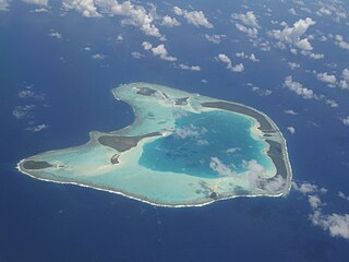
An atoll is a ring-shaped island, including a coral rim that encircles a lagoon. There may be coral islands or cays on the rim. Atolls are located in warm tropical or subtropical parts of the oceans and seas where corals can develop. Most of the approximately 440 atolls in the world are in the Pacific Ocean.

A lagoon is a shallow body of water separated from a larger body of water by a narrow landform, such as reefs, barrier islands, barrier peninsulas, or isthmuses. Lagoons are commonly divided into coastal lagoons and atoll lagoons. They have also been identified as occurring on mixed-sand and gravel coastlines. There is an overlap between bodies of water classified as coastal lagoons and bodies of water classified as estuaries. Lagoons are common coastal features around many parts of the world.

Aldabra is the world's second-largest coral atoll, lying southeast of the continent of Africa. It is part of the Aldabra Group of islands in the Indian Ocean that are part of the Outer Islands of the Seychelles, with a distance of 1,120 km (700 mi) southwest of the capital, Victoria on Mahé Island.

Tubuai, Tubuaʻi or Tupuaʻi is the main island of the Austral Island group, located 640 km (400 mi) south of Tahiti. In addition to Tubuai, the group of islands include Rimatara, Rurutu, Raivavae, Rapa and the uninhabited Îles Maria. They are part of the Austral Islands in the far southwest of French Polynesia in the south Pacific Ocean. Tubuai island sustains a population of 2,217 people on 45 km2 of land. Due to its southerly position, Tubuai has notably cooler weather than Tahiti.

Heron Island is a coral cay located near the Tropic of Capricorn in the southern Great Barrier Reef, 80 kilometres north-east of Gladstone, Queensland, Australia, and 460 km (290 mi) north-north-west of the state capital Brisbane. The island is situated on the leeward (western) side of Heron Reef, a fringing platform reef of significant biodiversity, supporting around 900 of the 1,500 fish species and 72% of the coral species found on the Great Barrier Reef. During the summer months Heron Island is also home to over 200,000 birds including Noddy Terns and Mutton Birds.

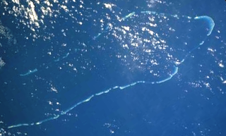
The New Caledonian barrier reef is a barrier reef located in New Caledonia in the South Pacific, being the longest continuous barrier reef in the world and the third largest after the Great Barrier Reef of Australia and the Mesoamerican Barrier Reef.

Lady Musgrave Island is a 14 hectares coral cay on Australia's Great Barrier Reef, with a 1,192 hectares surrounding reef. The island is the second southernmost island in the Great Barrier Reef chain of islands. The Island is named after Lady Lucinda Musgrave, the wife of Sir Anthony Musgrave, a colonial governor of Queensland.

Banc du Geyser is a mostly submerged reef in the Mozambique Channel's northeastern part, 125 km (78 mi) northeast from Mayotte, 112 km (70 mi) southwest of the Glorioso Islands and 200 km (124 mi) off the northwestern coast of Madagascar.
Bushy Island is a vegetated coral cay in Queensland, Australia in the Great Barrier Reef Marine Park Queensland, Australia. It is about 70 km east of Mackay. There are no other vegetated cays in the more than 600 km stretch between Bushy Island and Green Island. The coral species Acropora bushyensis, one of many species in the genus Acropora, is most heavily concentrated in Bushy Island lagoon, existing only rarely elsewhere in the eastern portion of the Great Barrier Reef and not at all in the western portion. The island is an accumulation of biogenic sediment similar to Heron Island, and it has been sufficiently stable to accumulate vegetation. A major component of the mobile sands of Bushy Island is Foraminifera, a type of amoeboid protist. Foraminiferan sands are more easily eroded off of the cay. Bushy Island is located inside the zero isobase on an elevated reef flat, onto which the cay often erodes.

The Chesterfield Islands are a French archipelago of New Caledonia located in the Coral Sea, 550 km (300 nmi) northwest of Grande Terre, the main island of New Caledonia. The archipelago is 120 km long and 70 km broad, made up of 11 uninhabited islets and many reefs. The land area of the islands is less than 10 km2.
The Islets of Mauritius includes circa a hundred and thirty tiny islets and rocks scattered around the coast of Mauritius, Rodrigues, Agalega and St Brandon.
One Tree Island is a small coral cay. It is located near the Tropic of Capricorn in the southern Great Barrier Reef, 96 km due east nor east of Gladstone, Queensland, Australia, and 450 km north of the state capital Brisbane. The island is part of the Great Barrier Reef chain of islands, and is part of the Capricorn and Bunker Group of island and forms part of the Capricornia Cays National Park. It is also part of the Capricornia Cays Important Bird Area.
Tryon Island is a coral cay located in the southern Great Barrier Reef, 86 km northeast of Gladstone, Queensland, Australia, and 465 km north of the state capital Brisbane. The island is a protected area and forms part of Capricornia Cays National Park. It is part of the Capricornia Cays Important Bird Area. The cay covers an area of 0.21 square kilometres and is surrounded by a coral reef that is partially exposed at low-tide.
Bramble Cay, also known as Maizab Kaur and Massaramcoer, is a small cay located at the northeastern edge of Australia and the Torres Strait Islands of Queensland and at the northern end of the Great Barrier Reef. Lying around 50 km (31 mi) north of Erub Island in the Gulf of Papua, it is the northernmost point of land of Australia and marks the end of the Great Barrier Reef.

The Sea of Abaco, located in The Bahamas, is an approximately 100 kilometres long saltwater lagoon separating Great Abaco Island from a chain of barrier islands known as the Abaco Cays. Depths in the Sea of Abaco are generally a few metres, and shallow reefs and shoals can pose a serious hazard to navigation. Despite these hazards, the sea is popular with boaters and is sometimes referred to as a 'marine highway', offering a sheltered passage through the Abaco Islands. The majority of the largest settlements and towns in the Abaco Islands are located along the shores of the sea.

Lighthouse Reef is an atoll in the Caribbean Sea, the easternmost part of the Belize Barrier Reef and one of its three atolls, the other two being Turneffe Atoll and Glover's Reef. Lighthouse Reef is located about 80 kilometres (50 mi) southeast of Belize City. The atoll is of oblong shape, approximately 35 kilometres (22 mi) long from north to south, and about 8 kilometres (5.0 mi) wide. It forms a shallow sandy lagoon with an area of 120 square kilometres (46 sq mi) and a depth between 2 and 6 metres deep.

The Coral reefs of the Solomon Islands consists of six major islands and over 986 smaller islands, in Oceania, to the east of Papua New Guinea and northwest of Vanuatu. The Solomon Islands lie between latitudes 5° and 13°S, and longitudes 155° and 169°E. The distance between the westernmost and easternmost islands is about 1,500 km (930 mi). The Santa Cruz Islands are situated north of Vanuatu and are especially isolated at more than 200 km (120 mi) from the other islands. The Solomon Islands has the 22nd largest Exclusive Economic Zone of 1,589,477 km2 (613,701 sq mi) of the Pacific Ocean.