
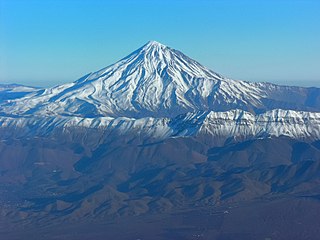
Tochal, is a mountain and ski resort located on the Alborz mountain range, adjacent to the metropolitan area of Tehran in northern Iran. It includes a 12-kilometre-long (7.5 mi) ridge. Its highest peak, also called Tochal, is at an elevation of 3,963 metres (13,002 ft) above sea level.

The Tehran Metro is a rapid transit system serving Tehran, the capital of Iran. It is the largest metro system in the Middle East. The system is owned and operated by Tehran Urban and Suburban Railway. It consists of six operational metro lines, with construction under way on four lines including northwestern extension of line 4, south extension line 6, north and east extension line 7 and Line 10.

The MacLehose Trail is a 100-kilometre hiking trail that crosses much of the New Territories, Hong Kong, starting from Pak Tam Chung, Sai Kung District in the east to Tuen Mun Town, Tuen Mun District in the west. The path is marked by distance posts at 500-metre intervals. The trail is named after Murray MacLehose, Baron MacLehose of Beoch, the longest-serving governor of Hong Kong, who established the Country Parks and was himself an enthusiastic hiker. The trail passes through a variety of natural scenery including beaches and mountains.

The Israel National Trail is a hiking trail that crosses the entire length of the country of Israel, with its northern end at Kibbutz Kfar Giladi, near the Lebanese border in the far north of the country, extending to Eilat at the southernmost tip of Israel on the Red Sea, with a total length of 1,040 km (650 mi). The trail was inaugurated in 1995.

The Islamic Republic of Iran Railways is the national state-owned railway system of Iran. The Raja Passenger Train Company is an associate of the IR, and manages its passenger trains. The Railway Transportation Company is an associate of the IR, which manages its freight transport. The Ministry of Roads & Urban Development is the state agency that oversees the IRIR. Some 33 million tonnes of goods and 29 million passengers are transported annually by the rail transportation network, accounting for 9 percent and 11 percent of all transportation in Iran, respectively (2011).

The Mid State Trail (MST) is a 327-mile (526 km) linear hiking trail located in the Appalachian Mountains and Allegheny Plateau of central Pennsylvania, United States. It is the longest hiking trail in Pennsylvania, and one of just three to traverse the state from one border to another. A portion of the Mid State Trail is also part of the Great Eastern Trail.
Amol County is in Mazandaran province, Iran. Its capital is the city of Amol.

Nikkaluokta is a Swedish Sami village in Norrbotten County. The village belongs to Gällivare Municipality, bordering Kiruna Municipality, the closest urban area some 60 kilometers away. In its vicinity lie the areas of two Sami communities, Laevas and Girjas, who still herd semi-domesticated reindeer in the region.

The National Blue Trail is a national trail in Hungary, for most of its length part of the European Long Distance Walking Route E4. The route starts atop the Írott-kő Mountain on the Austrian-Hungarian border then leads across Hungary eventually ending 1,170 km later at the village of Hollóháza by the Hungarian-Slovakian border.. The name of the Kéktúra is a reference to the marking of the path itself: it is a horizontal blue stripe on a white rectangle. All segments of the trail are freely accessible to the public; no fees have to be paid or permits obtained, there is only one ferry to take over the Danube between Visegrád and Nagymaros where you have to purchase a ticket. Although to have an official completion, you have to purchase a stamping brochure from MTSZ, the organizer of the trail.

Shahran is a neighbourhood in north-west Tehran, Iran.
The Red Bull X-Alps is a paragliding race in which athletes must hike or fly 1,200 km across the Alps. It first launched in 2003 and has since taken place every other year. Around 30 athletes take part and must navigate their way via a predetermined set of turn points that vary with each race. Every kilometer must be covered either on foot or by paraglider. Teams consist of one athlete and one official supporter, whose role it is to provide technical advice, mental and nutritional support.

A long-distance trail is a longer recreational trail mainly through rural areas used for hiking, backpacking, cycling, horse riding or cross-country skiing. They exist on all continents except Antarctica.

Najmabad is a village in, and the capital of, Najmabad Rural District of the Central District of Nazarabad County, Alborz province, Iran.

Zahedan Railway Station is located in Zahedan, Iran. It serves as the terminus for the Quetta–Taftan Railway Line and Bam-Zahedan railway. It also serves as the break of gauge between Pakistan Railways 1,676 mm broad gauge and Islamic Republic of Iran Railways 1,435 mmstandard gauge. It is one of three Pakistan Railways stations in Iran.
The Ostweg is a north-south long-distance path through the Black Forest from Pforzheim to Schaffhausen. The roughly 240-kilometre-long ridgeway was laid out in 1903 and has been managed and maintained since then by the Black Forest Club. Its waymark is a black and red diamond on a white background.

The Kaiserstuhl–Rhine Black Forest Trail is an east–west hiking trail of several days' duration through the Black Forest in Germany from Donaueschingen to Breisach. The 109-kilometre-long hiking trail is managed and maintained by the Black Forest Club.
The Selvaggio Blu is a trekking route in the territory of the district of Baunei (Sardinia). It was conceived in 1987 by Mario Verin, and Peppino Cicalò (architect), President of the Nuoro section of the Italian Alpine Club. The itinerary extends for over 40 kilometers from the touristic port of Santa Maria Navarrese (Baunei) to the beach of Cala Sisine (Baunei). It takes on average 4 days to complete.


