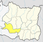
Banke District (Nepali: बाँके जिल्ला[bãke], a part of Lumbini Province, is one of the 77 districts of Nepal. The district, located in midwestern Nepal with Nepalganj as its district headquarters, covers an area of 2,337 km2 and had a population of 385,840 in 2001 and 491,313 in 2011. There are three main cities in the Banke District: Nepalganj, Kohalpur and Khajura Bajaar.

Gaighat is an administrative centre within Triyuga Municipality and the headquarter of Udayapur District located in Province No. 1 of Nepal. Gaighat is divided into 2 wards called Gaighat Bazar and Old Gaighat. The Gaighat is located in Ward No. 11 and Old Gaighat is in Ward No. 12 of Triyuga Municipality. Total area of two wards is 16.11 square kilometres (6.22 sq mi) and total population is 14,243 with 2832 households.
Aaptar was a village development committee in Udayapur District in the Sagarmatha Zone of Eastern Development Region of Nepal. It became part of Rautamai Rural Municipality after reconstruction of administration in Nepal.
Bărăi is a village development committee in Udayapur District in the Sagarmatha Zone of south-eastern Nepal. At the time of the 1991 Nepal census it had a population of 4613.
Dumre is a village development committee in Udayapur District in the Sagarmatha Zone of south-eastern Nepal. At the time of the 1991 Nepal census it had a population of 11,749 people living in 2510 individual households.
Jalpachilaune is a populated place located in Triyuga municipality of Udayapur District in Province No. 1 of Nepal. At the time of 2011 Nepal census it had a population of 3,864 people living in 807 individual households.
Jante is a village development committee in Udayapur District in the Sagarmatha Zone of south-eastern Nepal. At the time of the 1991 Nepal census it had a population of 2142 people living in 385 individual households.
Jogidaha is a populated place located in Triyuga municipality of Udayapur District in Province No. 1 of Nepal. At the time of 2011 Nepal census it had a population of 6,665 people living in 1,451 individual households.
Katari is a Municipality in Udayapur District in the Province No. 1 of south-eastern Nepal.It lies by the Tawa river having the bridge of length 123.5m. This was established by merging two existing village development committees i.e. Triveni and Katari on 18 May 2014. At the time of the 1991 Nepal census it had a population of 7230 people living in 1410 individual households. Thirty years later, Katari had undergone rapid growth, achieving a population of 56,146 people by the 2011 census.
Khanbu is a populated place located in Triyuga municipality of Udayapur District in Province No. 1 of Nepal. At the time of 2011 Nepal census it had a population of 4,350 people living in 782 individual households.
Okhale is a village development committee in Udayapur District in the Sagarmatha Zone of south-eastern Nepal. At the time of the 1991 Nepal census it had a population of 2722 people living in 507 individual households.
Panchawati is a village in, and headquarter of, Udayapurgadhi rural municipality in Udayapur District in Province No. 1 of south-eastern Nepal. At the time of the 1991 Nepal census it had a population of 6,580 people living in 1223 individual households.
Mayankhu is a village in Katari Municipality of Udayapur District. This was previously a village development committee in Udayapur District in the Sagarmatha Zone of south-eastern Nepal. At the time of the 1991 Nepal census it had a population of 2575.
Saune is a populated place located in Triyuga municipality of Udayapur District in Province No. 1 of Nepal. At the time of 2011 Nepal census it had a population of 2,678 people living in 518 individual households.
Triveni is a town in Katari Municipality, Udayapur District, in the Sagarmatha Zone of south-eastern Nepal. The formerly Triveni village development committee was merged to form a new municipality from 18 May 2014. At the time of the 1991 Nepal census, Triveni had a population of 6015 people, living in 1105 individual households.
Chaudandigadhi is a municipality in Udayapur District of Province No. 1 in Nepal that was established on 10 March 2017 by merging the former Village development committees Chaudandi, Siddipur, Hadiya and Sundarpur with the former municipality Beltar Basaha. At the time of the 2011 Nepal census, the localities out of which Chaudandigadhi would be formed had a joint population of 48,574 people living in 10,519 individual households. It is surrounded by Belka Municipality in the east, Triyuga in the west, the districts of Khotang and Bhojpur in the north and Sunsari District in the south.
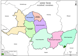
Udayapurgadhi Rural Municipality is a rural municipality in Udayapur district of Province No. 1 in Nepal. There are 4 rural municipalities in Udayapur district. There are 8 wards in this municipality. According to 2011 census of Nepal, the total population of the municipality is 30,731 and total area is 269.51 km². The headquarter of the municipality is in Panchawati
Rautamai Rural Municipality is a rural municipality in Udayapur district of Province No. 1 in Nepal. There are 4 rural municipalities in Udayapur district. There are 8 wards in this municipality. According to 2011 census of Nepal, the total population of the municipality is 23,481 and total area is 204 km². The headquarter of the municipality is in Bhuttar
Limchungbung (earlier:Sunkoshi) is a rural municipality in Udayapur district of Province No. 1 in Nepal. There are 4 rural municipalities in Udayapur district. There are 5 wards in this municipality. According to 2011 census of Nepal, the total population of the municipality is 11,992 and total area is 106.8 km². The headquarter of the municipality is in Baraha
Tapli Rural Municipality is a rural municipality in Udayapur district of Province No. 1 in Nepal. There are 4 rural municipalities in Udayapur district. There are 5 wards in this municipality. According to 2011 census of Nepal, the total population of the municipality is 14,567 and total area is 119. km². The headquarter of the municipality is in Rupatar