Related Research Articles
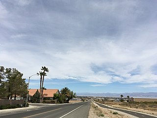
Ridgecrest is a city in Kern County, California, United States. It is located along U.S. Route 395 in the Indian Wells Valley in northeastern Kern County, adjacent to the Naval Air Weapons Station China Lake. The population was 27,616 at the 2010 census, up from 24,927 at the 2000 census. It was incorporated as a city in 1963.
The Fort Mohave Indian Reservation is an Indian reservation along the Colorado River, currently encompassing 23,669 acres (95.79 km2) in Arizona, 12,633 acres (51.12 km2) in California, and 5,582 acres (22.59 km2) in Nevada. Originally established in 1870, the reservation is home to approximately 1,100 members of the federally recognized Mohave Tribe of Native Americans.
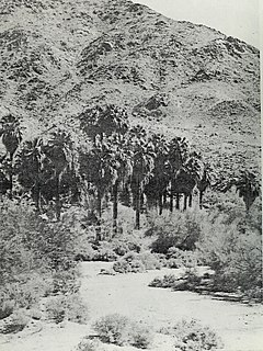
Corn Springs is a palm oasis situated in the Chuckwalla Mountains of the Colorado Desert in Riverside County, California, United States, seventeen miles southeast of Desert Center. Native Americans relied on the springs, and they engraved many petroglyphs on the rocks in the area. In the late 19th century, miners in the area also relied on the springs, and they established the Corn Springs Mining District in 1897.

The New York Mountains are a small mountain range found in northeastern San Bernardino County in California, USA. The range's northeastern area lies in southeastern Nevada. The range lies just south of the small community of Ivanpah, and north of the Lanfair Valley. The mountains are part of the mountain ranges, cones, mountains, and landforms in the Mojave National Preserve. The mountains reach an elevation of 7,533 feet (2,296 m), and run in a mostly southwest-northeasterly direction between the Providence Mountains and the McCullough Range approximately five miles into Nevada and border the northwest corner of the Piute Valley of Nevada-California.

Lanfair Valley is located in the Mojave Desert in southeastern California near the Nevada state line. It is bounded on the north by the New York Mountains and Castle Mountains, on the east by the Piute Range, and on the south by the Woods Mountains and Vontrigger Hills. Joshua Trees can be found in most of the valley. Elevation is 4,045 feet.

Northeast Arizona is a region of the U.S. state of Arizona commonly including Apache County and Navajo County. Some notable towns there are St. Johns, Eagar, Holbrook, Show Low, Winslow, Window Rock, Fort Defiance, Ganado, Chinle, and Kayenta.

The Mojave Road, also known as Old Government Road, is a historic route and present day dirt road across what is now the Mojave National Preserve in the Mojave Desert in the United States. This rough road stretched 147 miles (237 km) from Beale's Crossing, to Fork of the Road location along the north bank of the Mojave River where the old Mojave Road split off from the route of the Old Spanish Trail/Mormon Road.

Vanderbilt was a short-lived gold mining town located in San Bernardino County, California, United States. It existed between 1893 and 1895. At its peak it may have had a population of about 400 people.

The Providence Mountains State Recreation Area is located in the Providence Mountains, within the Mojave National Preserve in San Bernardino County, California. It is also home to the Mitchell Caverns Natural Preserve.
Coso Rock Art District, containing the Big and Little Petroglyph Canyons, is a rock art site containing over 100,000 Paleo-Indian and/or Native American Petroglyphs. The Coso Range is between the Sierra Nevada and the Argus Range. Indian Wells Valley lies to the south of this location. This north-south trending range of about 400 square miles (1,000 km2) consists of rhyolitic domes and outcrops of volcanic rock. Also known as Little Petroglyph Canyon and Sand Tanks, Renegade Canyon is but one of several major canyons in the Coso Range, each hosting thousands of petroglyphs. The majority of the Coso Range images fall into one of six categories: bighorn sheep, entopic images, anthropomorphic or human-like figures, other animals, weapons & tools, and "medicine bag" images. Most of the Coso Range is on the Naval Air Weapons Station China Lake, where visitation is restricted, vandalism is low, and preservation is most likely. China Lake is located near the towns of China Lake and Ridgecrest, California. There are several other distinct canyons in the Coso Rock Art District besides the Big and Little Petroglyph Canyons. The most popular subjects are bighorn sheep, deer, and antelope. Big and Little Petroglyph Canyons were declared a National Historic Landmark in 1964. In 2001, they were incorporated into a larger National Historic Landmark District, called Coso Rock Art District.

The Cleghorn Lakes Wilderness is a 33,475-acre (135.47 km2) wilderness area in the southern Mojave Desert. It is located 16 miles (26 km) northeast of Twentynine Palms, California, and 20 miles (32 km) north of Joshua Tree National Park. It is managed by the Bureau of Land Management.

Maturango Museum is located in Ridgecrest, California. The museum is best known for the guided tours of the Coso Rock Art District located on China Lake Naval Weapons Station. The museum offers exhibits and displays featuring both the natural and the cultural history and diversity of the Northern Mojave Desert with exhibits of animals, plants, rocks and minerals, Native American artifacts, and contemporary arts and crafts.
The Coso people are an indigenous people of the Americas and Native American tribe associated with the Coso Range in the Mojave Desert of California in the southwestern United States. They are of the Uto-Aztecan language and spoke one of several Numic languages, related to that of the Northern Paiute.
The Las Vegas Tribe of Paiute Indians of the Las Vegas Indian Colony is a federally recognized tribe of Southern Paiute Indians in southern Nevada.
Located in San Bernardino County, California approximately three miles northwest of Primm, NV and I-15, the small but pristine 7,004-acre (approximate) Stateline Wilderness contains the eastern terminus of the 15-mile long Clark Mountain Range.
Aiken's Wash is an archaeologically and geologically significant wash located in the Mojave National Preserve in San Bernardino County, California. The wash includes several pictograph and petroglyph sites dating from the late pre-Columbian period. The proximity of pictographs and petroglyphs is unusual in the Mojave Desert region. The area was added to the National Register of Historic Places as the Aiken's Wash National Register District. The district comprises 1,450 acres (590 ha), including all major archaeological sites in the wash.
Eagle Mountain is the tallest and northernmost summit in the Lanfair Buttes is Eagle Mountain in the Mojave National Preserve in the Mojave Desert in San Bernardino County, California. It rises to an elevation of 1338 feet.
References
Coordinates: 35°08′43″N115°09′32″W / 35.14528°N 115.15889°W

A geographic coordinate system is a coordinate system that enables every location on Earth to be specified by a set of numbers, letters or symbols. The coordinates are often chosen such that one of the numbers represents a vertical position and two or three of the numbers represent a horizontal position; alternatively, a geographic position may be expressed in a combined three-dimensional Cartesian vector. A common choice of coordinates is latitude, longitude and elevation. To specify a location on a plane requires a map projection.