Related Research Articles
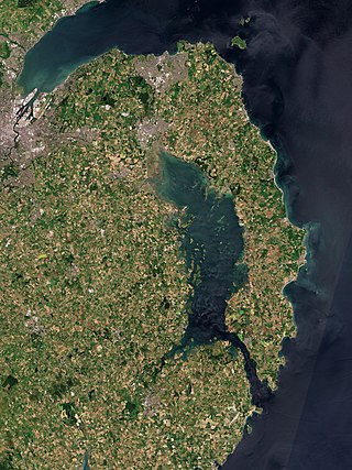
The Ards Peninsula is a peninsula in County Down, Northern Ireland, on the north-east coast of Ireland. It separates Strangford Lough from the North Channel of the Irish Sea. Towns and villages on the peninsula include Donaghadee, Millisle, Portavogie and Portaferry. The large towns of Newtownards and Bangor are at the mainland edge of the peninsula. Burr Point is the easternmost point on the island of Ireland.
A townland is a small geographical division of land, historically and currently used in Ireland and in the Western Isles in Scotland, typically covering 100–500 acres (40–202 ha). The townland system is of Gaelic origin, antedating the Norman invasion, and most have names of Irish origin. However, some townland names and boundaries come from Norman manors, plantation divisions, or later creations of the Ordnance Survey. The total number of inhabited townlands in Ireland was 60,679 in 1911. The total number recognised by the Irish Place Names database as of 2014 was 61,098, including uninhabited townlands, mainly small islands.
Donegore is the name of a hill, a townland, a small cluster of residences, and a civil parish in the historic barony of Antrim Upper, County Antrim, Northern Ireland. Donegore lies approximately 5 miles (8 km) east of Antrim town. 154 acres of the townland lies in the civil parish of Grange of Nilteen.

Saul is a village in County Down, Northern Ireland, within the civil parish of Saul and Ballee.
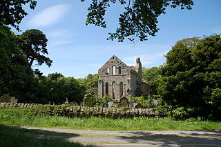
Greyabbey or Grey Abbey is a small village, townland and civil parish located on the eastern shores of Strangford Lough, on the Ards Peninsula in County Down, Northern Ireland.

Drumbeg is a small village, townland and civil parish on the south bank of the River Lagan in County Down, Northern Ireland. The village is covered by the Lisburn City Council area and forms part of the suburban fringe of Belfast.
Dunnaval is a small village and townland near Kilkeel in County Down, Northern Ireland. It is situated in the civil parish of Kilkeel and the historic barony of Mourne. In the 2001 Census it had a population of 147 people. It lies within the Newry and Mourne District Council area.

Carnteel ) is a hamlet, townland and civil parish, about 2 miles northeast of Aughnacloy in County Tyrone, Northern Ireland. It is situated in the historic barony of Dungannon Lower.
Ballynahatty is a townland in County Down, Northern Ireland. It lies on the southern edge of Belfast. It contains the Giants Ring, a henge monument.

Ringhaddy is a townland on the shores of Strangford Lough, County Down, Northern Ireland, 5 km south of Whiterock. It is in the civil parish of Killinchy and the historic barony of Dufferin.
Drumlough is a village/townland in County Down, Northern Ireland, southwest of Rathfriland, and is located in the civil parish of Drumgath.

Carrickfergus is a barony in County Antrim, Northern Ireland. It is bounded on the south-east by Belfast Lough, and otherwise surrounded by the barony of Belfast Lower. It is coextensive with the civil parish of Carrickfergus or St Nicholas and corresponds to the former county of the town of Carrickfergus, a county corporate encompassing Carrickfergus town.

Ballinderry is a civil parish and townland in County Antrim, Northern Ireland. It is situated in the historic barony of Massereene Upper.

Magheracross is a townland and civil parish in County Fermanagh, Northern Ireland. It extends in area from just north of Enniskillen to the border with County Tyrone and includes a small enclave in County Tyrone.

Tullynakill is a civil parish and townland in County Down, Northern Ireland. It is situated in the historic barony of Castlereagh Lower.
Drumgath is a civil parish in County Down, Northern Ireland, southwest of Rathfriland. It is situated in the historic barony of Iveagh Upper, Upper Half. It is also a townland of 375 acres.
Witter is a civil parish in County Down, Northern Ireland. It is situated in the historic barony of Ards Upper.

Legacurry is a townland of 100 acres in County Down, Northern Ireland. It is situated in the civil parish of Drumbo and the historic barony of Castlereagh Upper.
References
- 1 2 3 "Inishargy". IreAtlas Townlands Database. Retrieved 16 May 2015.