Kingston is a city in Ontario, Canada, on the northeastern end of Lake Ontario. It is at the beginning of the St. Lawrence River and at the mouth of the Cataraqui River, the south end of the Rideau Canal. Kingston is midway between Toronto, Ontario, and Montreal, Quebec, and is also near the Thousand Islands, a tourist region to the east, and the Prince Edward County tourist region to the west. Kingston is nicknamed the "Limestone City" because it has many heritage buildings constructed using local limestone.

The Beaches is a neighbourhood in Toronto, Ontario, Canada. It is so named because of its four beaches situated on Lake Ontario. It is located east of downtown within the "Old" City of Toronto. The approximate boundaries of the neighbourhood are from Victoria Park Avenue on the east to Kingston Road on the north, along Dundas Street to Coxwell Avenue on the west, south to Lake Ontario. The Beaches is part of the east-central district of Toronto.

Canadian Forces Base Kingston is a Canadian Forces base in Kingston, Ontario.

Downtown Calgary is a dense urban district in central Calgary, Alberta. It contains the second largest concentration of head offices in Canada, despite only being the country's fourth largest city in terms of population. The downtown is divided into several residential, commercial, corporate, and mixed-use neighbourhoods, including the Financial District (CBD), Eau Claire, Chinatown, East Village, Beltline, and the West End.

The Kingston railway station is an inter-city passenger rail station in Cataraqui, Kingston, Ontario, Canada. It is served by Via Rail trains running from Toronto to Ottawa or Montreal, along the Corridor route. It is located on John Counter Boulevard, northeast of Princess Street and northwest of downtown Kingston.

The Kingston, Ontario Inner Harbour is situated at the south end of the Cataraqui River northeast of the downtown core of Kingston, Ontario, Canada. It is the section of Kingston Harbour that is north of the La Salle Causeway.
Anglin Bay is a small bay on the western shore of the Cataraqui River at Kingston, Ontario. It is a prominent feature of the Kingston, Ontario Inner Harbour. The bay was named for the Anglin Company whose offices, lumber yard and mill were continuously located on the shore of the bay from 1865 to 1999. The S. Anglin Fuel Company was originally a timber company, incorporated in Kingston in 1865, which gradually worked its way through building materials and lumber, coal, and oil as home heating fuels changed over the years. Timber was originally transported by the Cataraqui River, and later by the Kingston and Pembroke Railway, a now-defunct Canadian Pacific line.

Downtown Vancouver is the central business district and the city centre neighbourhood of Vancouver, Canada, on the northwestern shore of the Burrard Peninsula in the Lower Mainland region of British Columbia. It occupies most of the north shore of the False Creek inlet, which cuts into the Burrard Peninsula creating the Downtown Peninsula, where the West End neighbourhood and Stanley Park are also located.

Downtown Toronto is the main central business district of Toronto, Ontario, Canada. Located entirely within the district of Old Toronto, it is approximately 16.6 square kilometres in area, bounded by Bloor Street to the northeast and Dupont Street to the northwest, Lake Ontario to the south, the Don Valley to the east, and Bathurst Street to the west. It is also the home of the municipal government of Toronto and the Government of Ontario.
The Kingston Centre was an indoor mall built in Kingston, Ontario in 1955 and demolished in 2004. The Kingston Centre name now belongs to a 223,327 sq ft (20,747.8 m2). campus-style open-air shopping centre on the same site, which replaced the now-demolished indoor mall.
Cataraqui Golf and Country Club is a private golf and curling club located in Kingston, Ontario, Canada. It was founded in 1917.

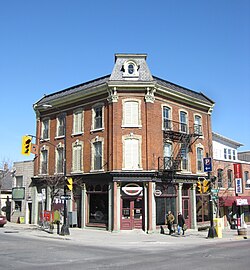
Princess Street is a major arterial road in Kingston, Ontario, Canada. As the main retail street of downtown Kingston, it is lined by many historic limestone buildings in the city's downtown core.

The La Salle Causeway is a causeway that allows Highway 2 to cross the Cataraqui River at Kingston, Ontario. The causeway separates Kingston's inner and outer harbours. Construction of the causeway was completed on April 15, 1917.

Sydenham is a central business district located in Kingston, Ontario, Canada. The Sydenham district for census purposes is bounded by Lake Ontario to the south and east, by Princess Street to the north and Barrie Street to the west. These boundaries do not coincide with the Sydenham Ward boundaries for city councillor elections as they include parts of the downtown main street.
Lemoine Point Conservation Area is a 136-hectare (340-acre) recreational conservation area at the west end of Kingston, Ontario. The area is bordered by Collins Bay on the north and west sides, Lake Ontario on the south and Kingston/Norman Rogers Airport on the east.
Kingston Mills, located approximately 7 kilometres (4.3 mi) north of downtown Kingston, Ontario, is the southernmost lockstation and one of 24 lockstations of the Rideau Canal system. Kingston Mills is a component of the Rideau Canal National Historic Site, and along with the rest of the Rideau Canal, is a World Heritage Site. The site is managed and operated by Parks Canada.

Alwington is a neighbourhood west of downtown Kingston, Ontario, Canada. The district is bordered by Union Street to the north, Sir John A. Macdonald Boulevard to the west, Lake Ontario to the south, and Albert Street to the east.

Portsmouth Village is a formerly incorporated village in Ontario which was annexed to become a neighbourhood of Kingston, Ontario, Canada in 1952.

Kingston City Hall is the seat of local government in Kingston, Ontario, Canada. Occupying a full city block facing Lake Ontario in Kingston's downtown, the city hall is a prominent building constructed in the Neoclassical style with a landmark tholobate and dome.
Williamsville is a neighbourhood located in downtown Kingston, Ontario, Canada. The neighbourhood is bounded by Concession Street to the north, Johnson Street to the south and Sir John A Macdonald Blvd to the west, and Division Street to the east. Williamsville is represented on the City Council by counsellor Jim Neill and is also home to the Williamsville Community Association, a local advocacy group committed to the interests of Williamsville's residents, businesses, and agencies.