Related Research Articles

Morrison County is a county in the U.S. state of Minnesota. As of the 2020 census, the population was 34,010. Its county seat is Little Falls. Camp Ripley Military Reservation occupies a significant area in north-central Morrison County.

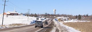
Carleton Place is a town in Eastern Ontario, Canada, in Lanark County, about 46 kilometres (29 mi) west of downtown Ottawa. It is located at the crossroads of Highway 15 and Highway 7, halfway between the towns of Perth, Almonte, Smiths Falls, and the nation's capital, Ottawa. Canada's Mississippi River, a tributary of the Ottawa River flows through the town. Mississippi Lake is just upstream by boat, as well as by car.
Chippawa is a community located within the city of Niagara Falls, Ontario.

The Mississippi River is a tributary of the Ottawa River in Eastern Ontario, Canada which has no relation with the Mississippi River in the United States. It is 200 kilometres (120 mi) in length from its source at Mackavoy Lake, has a drainage area of 4,450 square kilometres (1,720 sq mi), and has a mean discharge of 40 cubic metres per second (1,400 cu ft/s). There are more than 250 lakes in the watershed.

Lanark County is a county located in the Canadian province of Ontario. Its county seat is Perth, which was first settled in 1816. Most European settlements of the county began in 1816, when Drummond, Beckwith and Bathurst townships were named and initially surveyed. The first farm north of the Rideau was cleared and settled somewhat earlier, in 1790. The county took its name from the town of Lanark in Scotland. Nearly all the townships were named after British public and military figures from the era of early settlement.

Drummond/North Elmsley is a township in eastern Ontario, Canada in Lanark County. It is situated on the north shore of the Rideau River between the town of Perth and the town of Smiths Falls. It is a predominantly rural municipality. The township offices are located in the hamlet of Port Elmsley.
Whitewater Region is a township on the Ottawa River in Renfrew County, located within the scenic Ottawa Valley in eastern Ontario, Canada. Whitewater Region is made up of the former municipalities of Beachburg, Cobden, Ross and Westmeath, which were amalgamated into the current township on January 1, 2001.
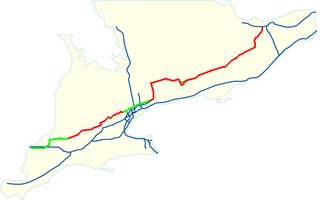
King's Highway 7, commonly referred to as Highway 7 and historically as the Northern Highway, is a provincially maintained highway in the Canadian province of Ontario. At its peak, Highway 7 measured 716 km (445 mi) in length, stretching from Highway 40 east of Sarnia in Southwestern Ontario to Highway 17 west of Ottawa in Eastern Ontario. However, due in part to the construction of Highways 402 and 407, the province transferred the sections of Highway 7 west of London and through the Greater Toronto Area to county and regional jurisdiction. The highway is now 535.7 km (332.9 mi) long; the western segment begins at Highway 4 north of London and extends 154.1 km (95.8 mi) to Georgetown, while the eastern segment begins at Donald Cousens Parkway in Markham and extends 381.6 km (237.1 mi) to Highway 417 in Ottawa.
Herron's Mills, originally known as Gillies Mills, is a ghost town in the municipality of Lanark Highlands, Lanark County in Eastern Ontario, Canada, near the community of Lanark. It is located on highway 511 between Perth and Calabogie, Ontario.

Unorganized North Algoma District is an unorganized area in northeastern Ontario, Canada, comprising all areas in Algoma District, north of the Sault Ste. Marie to Elliot Lake corridor, which are not part of an incorporated municipality or a First Nation. It covers 44,077.03 km2 (17,018.24 sq mi) of land, and had a population of 6050 in 2021. Many of these communities were/are stations on the Algoma Central Railway or were logging/mining towns.

Galetta is a dispersed rural community in West Carleton-March Ward in rural western Ottawa, Ontario, Canada. It is located on the Mississippi River near its mouth in the Ottawa River. Once part of Fitzroy Township and later West Carleton, it is now part of the city of Ottawa.
King's Highway 15, commonly referred to as Highway 15, is a provincially maintained highway in the Canadian province of Ontario. It travels north from an interchange with Highway 401 in Kingston to Highway 7 in Carleton Place, a distance of 114.7 kilometres (71.3 mi). In addition to Kingston and Carleton Place, the highway provides access to the Eastern Ontario communities of Joyceville, Seeley's Bay, Morton, Elgin, Crosby, Portland, Lombardy and Franktown. Prior to 1998, Highway 15 continued north from Carleton Place, passed Almonte and through Pakenham, to Highway 17 in Arnprior.
The City of Memphis is located on the eastern bank of the Mississippi River in the southwest corner of the U.S. state of Tennessee. It is the regional hub for a tri-state area of Arkansas, Mississippi and Tennessee.

Ompah is a village in eastern Ontario, Canada, located in the township of North Frontenac, approximately 100 kilometres (62 mi) southwest of Ottawa. The village is situated close to many lakes including Palmerston Lake, Canonto Lake, Sunday Lake, and Mosque Lake.

Kanata—Carleton is a federal electoral district in Ottawa, Ontario.

Lanark—Frontenac—Kingston is a federal electoral district in Eastern Ontario, Canada.
King's Highway 29, commonly referred to as Highway 29, was a provincially maintained highway in the Canadian province of Ontario. The 52.29-kilometre (32.49 mi) route connected Highway 2 in downtown Brockville with Highway 15 south of Smiths Falls. Between those larger settlements, it provided access to the communities of Forthton, Addison, Frankville, Toledo and Newbliss.
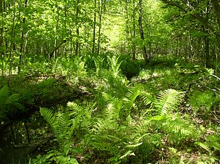
Scotch Corners Wetland is a provincially significant wetland complex located in Lanark County, Ontario, Canada. The 202 hectares area has a wide array of wetland types including swamps, marshes, vernal pools, beaver ponds and seepage areas. It forms the headwaters of several creeks that drain into Mississippi Lake.
Kanata—Carleton is a provincial electoral district in Ottawa, Ontario which was first contested in the 2018 provincial election.
References
- 1 2 Ebbs, John C. (1999-01-01). A History of Drummond Township. GeneralStore PublishingHouse. ISBN 9781894263146.