
Jämtland County is a county or län in the middle of Sweden consisting of the provinces of Jämtland and Härjedalen, along with minor parts of Hälsingland and Ångermanland, plus two small uninhabited strips of Lapland and Dalarna. Jämtland County constitutes 12 percent of Sweden's total area, 49,443 km2 (19,090 sq mi) and is the third largest county in the country. The county capital is Östersund and the county governor, appointed by the Swedish government, is Jöran Hägglund, who leads the administrative board. Jämtland County borders the counties of Dalarna, Gävleborg, Västernorrland, and Västerbotten. It also shares a border with the Norwegian county of Trøndelag.
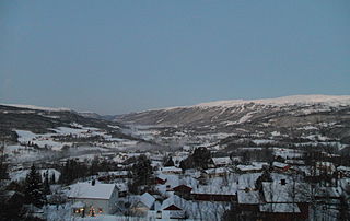
Meråker is a municipality in Trøndelag county, Norway. It is part of the Stjørdalen region. The administrative centre of the municipality is the village of Midtbygda which is about 20 kilometres (12 mi) west of Storlien in Sweden and 46 kilometres (29 mi) east of the town of Stjørdalshalsen in neighboring Stjørdal municipality. Other villages in Meråker include Gudåa, Kopperå, and Stordalen.

Stjørdal or Skierde is a municipality in Trøndelag county, Norway. It is part of the Stjørdalen region. The administrative centre of the municipality is the town of Stjørdal, also called Stjørdalshalsen. Some of the villages in the municipality include Elvran, Flornes, Hegra, Hell, Kvithammer, Prestmoen, Skatval, Skjelstadmarka, Sona, and Værnes.
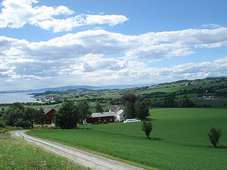
Frosta is the smallest municipality in Trøndelag county, Norway. The administrative centre is the village of Frosta. The municipality is located along the Trondheimsfjord, on the Frosta peninsula, just north of the city of Trondheim. It also includes the island of Tautra which is connected to the mainland by a causeway bridge.

Verdal is a municipality in Trøndelag county, Norway. It is part of the Innherad region. The administrative centre of the municipality is the town of Verdalsøra. Some villages in the municipality include Forbregd/Lein, Lysthaugen, Stiklestad, Trones, Vera, Vinne, and Vuku.

Snåsa (Norwegian) or Snåase (Southern Sami) is a municipality in Trøndelag county, Norway. It is part of the Innherred region. The administrative centre of the municipality is the village of Snåsa. Other villages include Agle and Jørstad.

Stjørdalen is a valley and a traditional district in Trøndelag county, Norway. The valley follows the river Stjørdalselva river from the border with Sweden 75 kilometres (47 mi) to the west where it empties into the Trondheimsfjorden. The valley traverses the present-day municipalities of Stjørdal and Meråker. The European route E14 highway and the Meråker Line railway follow the river through the length of the valley.
Fiborgtangen is a peninsula and industrial site located along Trondheimsfjord in the northwest part of the village of Skogn in the municipality of Levanger in Trøndelag county, Norway. The 500-decare site hosts the paper mill Norske Skog Skogn and the associated port used to ship newsprint away from the plant. Fiborgtangen is also the site chosen by Industrikraft Midt-Norge to build a thermal power plant powered by natural gas.

Central Norway is an administrative division that includes the counties of Trøndelag and Møre og Romsdal and is used by, for example, the regional health authorities and the Norwegian Public Roads Administration. Compared to the traditional regions of Norway it covers all of Trøndelag and some of Vestlandet. It has a total population of just under 760,000 people, with the Trondheim metropolitan region accounting for roughly 275,000.

Frostating Court of Appeal is a court of appeal located in the city of Trondheim, Norway. It serves as a court of appeal for the counties of Trøndelag and Møre og Romsdal in Central Norway. There are 19 permanent judges on this court, which is led by Sven-Jørgen Lindsetmo, the chief judge.
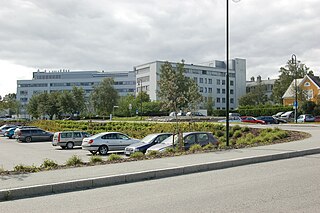
Levanger Hospital is a hospital located in the town of Levanger in the municipality of Levanger in Trøndelag county, Norway. The hospital is located along the road Kirkegata on the west side of the town of Levanger.

Sør-TrøndelagUrban East Norwegian: [²søːrˌtrœndəlɑːɡ](listen) was a county comprising the southern portion of the present-day Trøndelag county in Norway. It bordered the old Nord-Trøndelag county as well as the counties of Møre og Romsdal, Oppland, and Hedmark. To the west is the Norwegian Sea, and to the east is Jämtland in Sweden. The county was separated into a northern and southern part by the Trondheimsfjord. Slightly over 200,000 of the county's population lives in the city of Trondheim and its suburbs. The Norwegian dialect of the region is Trøndersk.

Inderøy District Court was a district court serving the municipalities of Steinkjer, Inderøy, Snåsa, Mosvik, Verran, and Namdalseid in Nord-Trøndelag county, Norway. It was a court of first instance and cases decided here could be appealed to the Frostating Court of Appeal. While the court is named for the neighboring municipality of Inderøy, the court was located in the town of Steinkjer.

Norwegian County Road 774 is a 4.2-kilometre (2.6 mi) long county road in the municipality of Levanger in Trøndelag county, Norway. It begins at the junction with the European route E06 highway at the village of Mule. It then heads into and through parts of the town of Levanger. There, the road continues as the Levanger–Hokstad Ferry operated by Tide Sjø to the village of Hokstad on the island of Ytterøya. After the ferry, the road changes to Norwegian County Road 135.
Inntrøndelag District Court is the district court serving the Inntrøndelag region in Trøndelag county, Norway. This court serves the municipalities of Steinkjer, Inderøy, Snåsa, Verran, Verdal, Levanger, Frosta, Stjørdal, Meråker, and Namdalseid.

The Folda is a river in Møre og Romsdal and Sør-Trøndelag, Norway. The river is part of the Surna watershed and flows into the Surna 7 kilometers (4.3 mi) west-southwest of the village of Rindal in the municipality of Rindal in the Nordmøre district. It has its source in the Trollheimen mountains. Two reservoirs lie along the course of the river: Lake Fold and Gray Lake. The Folda has a catchment area of 350 square kilometers (140 sq mi) and is fed by several tributaries: the Rinna, Bulu, and Vindøla. The name of the river comes from Old Norse Fold, probably meaning 'the broad one'.


