Related Research Articles

The North York Moors is an upland area in north-eastern Yorkshire, England. It contains one of the largest expanses of heather moorland in the United Kingdom. The area was designated as a National Park in 1952, through the National Parks and Access to the Countryside Act 1949. Covering an area of 554 sq mi (1,430 km2), the National Park has a population of 23,380. It is administered by the North York Moors National Park Authority, which is based in Helmsley.

Meanwood is a suburb and former village in north-west Leeds, West Yorkshire, England.

The Hogsmill River in Surrey and Greater London, England, is a small chalk stream tributary of the River Thames. It rises in Ewell and flows into the Thames at Kingston upon Thames on the lowest non-tidal reach, that above Teddington Lock.

Richmond is a suburb of Sheffield in South Yorkshire, England. It lies in the eastern part of the city.

Addlestone is a town in Surrey, England. It is located approximately 18+1⁄2 miles southwest of London. The town is the administrative centre of the Borough of Runnymede, of which it is the largest settlement.

Moor Park is a large park to the north of the city centre of Preston, Lancashire, England. Moor Park is also the name of the electoral ward covering the park and the surrounding area. The ward borders the traditional boundary of Fulwood. The population of the ward as at the 2011 census was 5,211.

The A171 is a road in England that links the North Yorkshire towns of Middlesbrough, Guisborough, Whitby, Robin Hood's Bay and Scarborough. Locally it is known as The Moor Road. The road is mostly single carriageway but has some sections of dual carriageway. The distance between the two towns is 47 miles (75 km)

Moor Grange Estate is a housing estate in the West Park area of Leeds, West Yorkshire, England, which was built in the 1950s on reclaimed farmland. Work on the Moor Grange Estate began in 1955. It was originally owned by the local council, and was leased by the council to tenants as a council estate. Most of the housing on the estate is now privately owned. Moor Grange does not suffer the crime problems of other council estates. House prices on the estate are high, and Moor Grange is considered a 'model council estate'. This may be due to the affluence of the area in which it is situated. Moor Grange backs onto the smaller Spen Estate which is another council estate in West Park. The Estate falls within the Kirkstall ward of the Leeds Metropolitan Council.
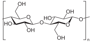
Beta-glucans, β-glucans comprise a group of β-D-glucose polysaccharides (glucans) naturally occurring in the cell walls of cereals, bacteria, and fungi, with significantly differing physicochemical properties dependent on source. Typically, β-glucans form a linear backbone with 1–3 β-glycosidic bonds but vary with respect to molecular mass, solubility, viscosity, branching structure, and gelation properties, causing diverse physiological effects in animals.

The Alden Valley is a small valley on the eastern edge of the West Pennine Moors, west of Helmshore in Rossendale, Lancashire, England. In the 14th century it was part of the Earl of Lincoln's hunting park. By 1840 it was home to about twenty farms, largely involved in cattle rearing, although most inhabitants were also involved with the production of textiles, which quickly developed during the Industrial Revolution into the building of textile mills. These have now been demolished and the valley is dominated by sheep grazing, with three working farms and a number of smallholdings.

ship-to-ship (STS) transfer operation is the transfer of cargo between seagoing ships positioned alongside each other, either while stationary or underway. Cargoes typically transferred via STS methods include crude oil, liquefied gas, bulk cargo, and petroleum products. The nomenclature STS transfer should be used in reference to techniques used by civilian merchant vessels, as differentiated from underway replenishment which is the term used by the US Navy for similar, but usually far more complicated, operations between naval vessels while underway.
Construction surveying or building surveying is to provide dimensional control for all stages of construction work, including the stake out of reference points and markers that will guide the construction of new structures such as roads, rail, or buildings. These markers are usually staked out according to a suitable coordinate system selected for the project.

Bracken Hall Countryside Centre and Museum is a children's museum, natural history education centre and nature centre established in 1989 at Bracken Hall on the edge of Baildon Moor, close to Shipley Glen in West Yorkshire, England.

The Alamo Canal was a 14 mi (23 km) long waterway that connected the Colorado River to the head of the Alamo River. The canal was constructed to provide irrigation to the Imperial Valley. A small portion of the canal was located in the United States but the majority of the canal was located in Mexico. The Alamo Canal is also known as the Imperial Canal.

Chapel Allerton is an inner suburb of north-east Leeds, West Yorkshire, England, 2 miles (3.2 km) from the city centre.

The Land Yeo is a small river which flows through North Somerset, England. It rises on Dundry Hill and supplies Barrow Gurney Reservoirs before flowing through various villages to Clevedon where it drains into the Severn Estuary. During the past 1,000 years it has powered at least ten watermills, however only one is still functional. Since 2003 initiatives have been undertaken to clean up the river, improving water quality and encouraging wildlife.
Harden Moor is an expanse of moorland that lies north of the village of Harden in West Yorkshire, England. The moor encompasses stretches of heather, woodland and former quarry workings and is bordered by Airedale to the east, the Worth Valley to the north and Catstones Moor and the village of Cullingworth to the west. Historically, Harden Moor occupied the high ground between Bingley, Keighley, Cullingworth and Harden. Altar Lane, an unmade road which runs from the Brown Cow Inn in Bingley to Keighley Road on Harden Moor is an unofficial border between the estate of St Ives and Harden Moor, but when the St Ives Estate was created, a large swathe of Harden Moor was taken over.

Quarry Moor is a Site of Special Scientific Interest, or SSSI, at the south edge of Ripon, North Yorkshire, England, and adjacent to the A61 road. It contains an outcrop of Magnesian Limestone, exposed by former quarrying. 255 million years ago this limestone was the peripheral sediment of a tropical sea. The land was donated in 1945 to the people of Ripon by the town's mayor, Alderman Thomas Fowler Spence, a varnish manufacturer. The land was notified as an SSSI in 1986 because its calcareous grassland supported a large diversity of plant species. The site features a Schedule 8 protected plant, thistle broomrape. The land is protected as a nature reserve, and it is also managed as a recreational area. Therefore, its calcareous grass area is fenced off for protection and study, but it also contains a car park, information signs, a children's play area, accessible paths, benches, and dog waste bins.

Swinefleet Warping Drain is an artificial waterway in the English county of the East Riding of Yorkshire, which was built to allow silt to be deposited on the peat moors, but now functions as a land drainage channel. It was constructed by Ralph Creyke, and the first section was completed in 1821.
References
- ↑ Bainbridge, T. H. (1943). "Land Utilisation in Cumbria in the Mid-Nineteenth Century as revealed by a Study of the Tithe Returns" (PDF). TCWAAS. 43: 93.
- ↑ Thornley, Rev. Canon (1897). "The Field Names of the Parish of Kirkoswald" (PDF). TCWAAS. 15: 76.
| | This article about geography terminology is a stub. You can help Wikipedia by expanding it. |
| | This article related to the history of England is a stub. You can help Wikipedia by expanding it. |
| | This agriculture article is a stub. You can help Wikipedia by expanding it. |