
Sabah is a state of Malaysia located on the northern portion of Borneo, in the region of East Malaysia. Sabah has land borders with the Malaysian state of Sarawak to the southwest and Indonesia's North Kalimantan province to the south. The Federal Territory of Labuan is an island just off the Sabah coast. Sabah shares maritime borders with Vietnam to the west and the Philippines to the north and east. Kota Kinabalu is the state capital city, the economic centre of the state, and the seat of the Sabah state government. Other major towns in Sabah include Sandakan and Tawau. The 2015 census recorded a population of 3,543,500 in the state, and in 2019 it was estimated to have grown to over 3.9 million. Sabah has an equatorial climate with tropical rainforests and abundant animal and plant species. The state has long mountain ranges on the west side which forms part of the Crocker Range National Park. Kinabatangan River, the second longest river in Malaysia runs through Sabah, and Mount Kinabalu is the highest point of Sabah as well as of Malaysia.
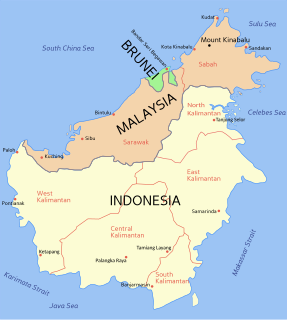
East Malaysia, also known as Sabah, Sarawak and Labuan or Malaysian Borneo, is the part of Malaysia on and near the island of Borneo, the world's third largest island. It consists of the Malaysian states of Sabah and Sarawak, as well as the Federal Territory of Labuan. Labuan is an island in a small archipelago near the coast of Sabah. East Malaysia lies to the east of Peninsular Malaysia, the part of the country on the Malay Peninsula. The two are separated by the South China Sea.

Keningau is the capital of the Keningau District in the Interior Division of Sabah, Malaysia. It is the fifth-largest town in Sabah, as well one of the oldest. Keningau is between Tambunan and Tenom. The town had an estimated population of 173,130.

The Murut are an indigenous ethnic group, comprising 29 sub-ethnic groups inhabiting the northern inland regions of Borneo. The Murutic languages are a family of half a dozen closely related Austronesian languages. The Murut can be found mainly in Sabah, Malaysia including in Sarawak, Malaysia, Brunei, and Kalimantan, Indonesia.

Malaysian Federal Roads System, is the main national road network in Malaysia. All Federal Roads in Malaysia are under the purview of the Ministry of Works (MOW). According to the Ministerial Functions Act 1969, the MOW is responsible to plan, build and maintain all Federal Roads gazetted under the Federal Roads Act 1959. However, most of the Federal roads' projects were built and maintained by the Malaysian Public Works Department (JKR), which is also one of the implementing agencies under the MOW.

Pan Borneo Highway, also known as Trans-Borneo Highway or Trans-Kalimantan Highway, is a road network on Borneo Island connecting two Malaysian states, Sabah and Sarawak, with Brunei and Kalimantan region in Indonesia. The highway is numbered AH150 in the Asian Highway Network and as Federal Route 1 in Sarawak. In Sabah, the route numbers given are 1, 13 and 22. The highway is a joint project between both governments which started as soon as the formation of Malaysia in 1963 which comprised Malaya, Sabah, Sarawak and Singapore. The lack of a road network system in Sarawak was the main factor of the construction.

Weston is a town on the west coast of the state of Sabah in Malaysia. It is located in the Interior Division of Sabah, and is about 100 kilometres south of Sabah's capital Kota Kinabalu. Weston is one of the towns along the Pan Borneo Highway.

Federal Route 22, Asian Highway Route AH150, is a 310-kilometre (193 mi) federal highway in Sabah, Malaysia, which is also a component of the larger Pan Borneo Highway network. It starts from Tamparuli and ends at Sandakan. The section running from Tamparuli to Ranau, which is known as Tamparuli-Ranau Highway, crosses the Crocker Range just to the south of Mount Kinabalu.

The Malaysian Public Works Department is the federal government department in Malaysia under Ministry of Works Malaysia (MOW) which is responsible for construction and maintenance of public infrastructure in West Malaysia and Labuan. In Sabah and Sarawak, a separate entity of Public Works Department exists under respective state government's jurisdiction but both departments are also subordinate to the parent department at the same time.
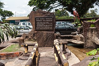
The Keningau Oath Stone is a monument in Keningau, Sabah erected to commemorate the terms in which the former British Crown Colony of North Borneo joined the former colony of Sarawak and the other states of the Federation of Malaya to form Malaysia.
The Sabah section of the Federal Route 1, Asian Highway Route AH150, is a 428-km federal highway in Sabah, Malaysia, which is also a component of the larger Pan Borneo Highway network. The route was formed in 1996 during the merging of two former routes A1 and A2. The merging of the former routes formed an alternate route of Route 1 within the city of Kota Kinabalu. However, most maps still use the older route numbering scheme by referring to the northern section as A1 and the southern section as A2.
Federal Route 502 is a 70-km federal highway in Sabah, Malaysia, connecting Beaufort to Menumbok before proceeding to Labuan via ferry services. This highway is commissioned as a tributary of the larger Pan Borneo Highway network, as it is the main highway from the main link to Labuan.
Federal Route 500 is a 163-kilometre (101 mi) federal highway in Sabah, Malaysia, connecting Kota Kinabalu to Tenom. It serves as the main highway from Kota Kinabalu to towns and villages in the Interior Division of Sabah. Federal Route 500 is one of the five highways in Sabah crossing the Crocker Range; the Tamparuli-Ranau Highway, Kimanis-Keningau Highway and Jalan Tenom-Sipitang are the other three and the new highway, Interior North–South Highway.
The Sarawak section of the Federal Route 1, Asian Highway Route AH 150, also known as Pan Borneo Highway Sarawak or Sarawak First Trunk Road, is a 1077-km federal highway in Sarawak, Malaysia, making the highway as the longest component of the Malaysian portion of the larger Pan Borneo Highway network. Construction of the highway began in 1965 after Sarawak became a member of the federation of Malaysia in 1963.
Federal Route 13, Asian Highway Route AH150, is a 268 km-long federal highway in Sabah, Malaysia. It is a component of the larger Pan Borneo Highway network. This highway runs primarily along the southeastern coast of Sabah from Sandakan to Tawau. The major towns it passes through include Kinabatangan, Lahad Datu and Kunak.

Pensiangan is a federal constituency in Interior Division, Sabah, Malaysia, that has been represented in the Dewan Rakyat from 1986 to 1995, from 2004 to present.
Beaufort is a federal constituency in Interior Division, Sabah, Malaysia, that has been represented in the Dewan Rakyat since 1995.
Sipitang is a federal constituency in Interior Division, Sabah, Malaysia, that has been represented in the Dewan Rakyat since 1995.
Keningau is a federal constituency in Interior Division, Sabah, Malaysia, that has been represented in the Dewan Rakyat since 1974.
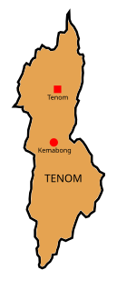
Tenom is a federal constituency in Interior Division, Sabah, Malaysia, that has been represented in the Dewan Rakyat since 1995.


