
Interstate 24 (I-24) is an Interstate Highway in the Midwestern and Southeastern United States. It runs diagonally from I-57, 10 miles (16 km) south of Marion, Illinois, to Chattanooga, Tennessee, at I-75. It travels through Illinois, Kentucky, Tennessee, and Georgia. As an even-numbered Interstate, it is signed as an east–west route, though the route follows a more southeast–northwest routing, passing through Nashville, Tennessee. The numbering deviates from the standard Interstate Highway System grid, lying further north than its number would indicate west of Nashville. The short segment within Georgia bears the unsigned designation State Route 409 (SR 409).

Brookport is a city in Massac County, Illinois, United States. The population was 725 at the 2020 census, down from 984 in 2010. It is part of the Paducah, KY-IL Metropolitan Statistical Area.

U.S. Route 45 is a major north-south United States highway and a border-to-border route, from Lake Superior to the Gulf of Mexico. A sign at the highway's northern terminus notes the total distance as 1,297 miles (2,087 km).

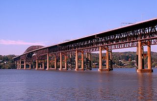
The Delaware Memorial Bridge is a dual-span suspension bridge crossing the Delaware River. The toll bridges carry Interstate 295 and U.S. Route 40 and is also the link between Delaware and New Jersey. The bridge was designed by the firm of Howard, Needles, Tammen & Bergendoff with consulting help from engineer Othmar Ammann, whose other designs include the George Washington Bridge and the Verrazzano-Narrows Bridge.
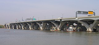
The Woodrow Wilson Memorial Bridge, also known as the Woodrow Wilson Bridge or the Wilson Bridge, is a bascule bridge that spans the Potomac River between Alexandria, Virginia and Oxon Hill, Maryland in Prince George's County, Maryland. The original bridge was one of only a handful of drawbridges in the Interstate Highway System. It contained the only portion of the Interstate System owned and operated by the federal government until construction was completed and it was turned over to the Virginia and Maryland departments of transportation.
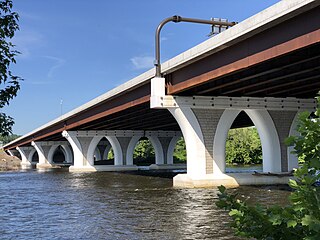
The Scudder Falls Bridge is a toll bridge that carries Interstate 295 (I-295) over the Delaware River, connecting Lower Makefield Township in Bucks County, Pennsylvania, with the Scudders Falls section of Ewing Township in Mercer County, New Jersey, United States. It is maintained by the Delaware River Joint Toll Bridge Commission (DRJTBC). The original bridge was a plate girder bridge constructed from 1958 to 1961, and the current structure is a box-girder bridge that partially opened in 2019 and was substantially complete in 2021. Previously, the bridge was a toll-free crossing. However, this changed on July 14, 2019, when an all-electronic toll was levied for Pennsylvania-bound traffic; the toll can be paid using E-ZPass or Toll-by-Plate.

The Interstate Bridge is a pair of nearly identical steel vertical-lift, Parker through-truss bridges that carry Interstate 5 traffic over the Columbia River between Vancouver, Washington and Portland, Oregon in the United States.
The Newburgh–Beacon Bridge is a continuous truss toll bridge that spans the Hudson River in New York State. The bridge carries Interstate 84 (I-84) and New York State Route 52 (NY 52) between Newburgh and Beacon and consists of two separate spans. The original northern span, which now carries westbound traffic, was opened on November 2, 1963, as a two-lane bridge. A second span, completed in 1980, now carries all eastbound traffic. The span provides connections to the New York State Thruway (I-87) and U.S. Route 9W (US 9W) in Newburgh and US 9 in Fishkill. The bridges includes a 2,204-foot-long (672 m) cantilever span, with a main span of 1,000 feet (300 m) and side spans of 602 feet (183 m). The total length of all spans and approaches is 7,855 feet (2,394 m) for the north span and 7,789 feet (2,374 m) for the south span. The bridges, owned by the New York State Bridge Authority, carry six lanes of traffic and approximately 65,000 vehicles per day. The bridge is officially known as the Hamilton Fish Newburgh–Beacon Bridge.

The Zilwaukee Bridge is a high-level, segmental concrete bridge spanning the Saginaw River in the U.S. state of Michigan. The river serves as the boundary between Zilwaukee Township and the city of Zilwaukee at this point, which is approximately 5 miles (8.0 km) north of downtown Saginaw. It carries Interstate 75 and US 23.

The 10th Avenue Bridge crosses the Mississippi River near downtown Minneapolis, Minnesota and also in proximity to the University of Minnesota. The bridge was historically referred to as the Cedar Avenue Bridge in the days prior to the construction of the I-35W Mississippi River bridge when it connected to Cedar Ave. The bridge connects 10th Avenue Southeast, on the east side of the Mississippi River, to 19th Avenue South on the west side. The Seven Corners area of the Cedar-Riverside, Minneapolis neighborhood is at the southern end of the bridge. The downstream end of the lower Saint Anthony Falls lock and dam extends under the bridge. The historic Southeast Steam Plant is also located nearby.
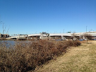
The 11th Street Bridges are a complex of three bridges across the Anacostia River in Washington, D.C., United States. The bridges convey Interstate 695 across the Anacostia to its southern terminus at Interstate 295 and DC 295. The bridges also connect the neighborhood of Anacostia with the rest of the city of Washington.

The Harahan Bridge is a cantilevered through truss bridge that carries two rail lines and a pedestrian bridge across the Mississippi River between West Memphis, Arkansas, and Memphis, Tennessee. The bridge is owned and operated by Union Pacific Railroad and is the second longest pedestrian/bicycle bridge in the United States. It was built with roadways cantilevered off the sides of the main structure for vehicles. These roadways are owned by the cities of Memphis, Tennessee, and Crittenden County, Arkansas, and were used from 1917–1949, until the Memphis & Arkansas Bridge opened 400 feet (120 m) south of the Harahan. The bridge was named in honor of railroad executive James Theodore Harahan, former president of the Illinois Central Railroad, who was killed in a railroad accident during the construction of the bridge. In February 2011, Union Pacific Railroad officials agreed to the idea of converting the 1917 roadways into a bicycle-pedestrian walkway across the river. In June 2012, Memphis was awarded a $14.9 million federal grant to build the walkway. The overall project was expected to cost $30 million, of which about $11 million was used for the Harahan Bridge portion. Construction was completed in 2016.

Canning Bridge is a traffic bridge which is the most downstream crossing of the Canning River in the city of Perth, Western Australia. The bridge is a part of Canning Highway, and it connects the suburbs of Como and Applecross. The Canning River is approximately 100 metres wide at the crossing, the narrowest point of the river along its downstream stretch. It is located near the Canning Bridge railway station.
The Charles M. Braga Jr. Memorial Bridge, also known as the Braga Bridge, or simply, The Braga, is a through truss bridge that carries Interstate 195 over the Taunton River between the town of Somerset and the city of Fall River, near the mouth of the Quequechan River at the confluence with Mount Hope Bay. At just over a mile long, The Braga Bridge spans 1.25 miles (2.01 km) and is one of the longest bridges in Massachusetts. Opened to traffic on April 15, 1966, it provides an important link between Providence, Rhode Island, Fall River, New Bedford, and Cape Cod.

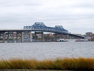
The Brookport Bridge is a ten-span, steel deck (grate), narrow two-lane truss bridge that carries U.S. Route 45 (US 45) across the Ohio River in the U.S. states of Illinois and Kentucky. It connects Paducah, Kentucky, north to Brookport, Illinois.
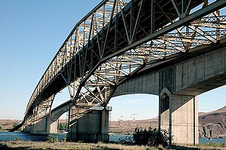
The Umatilla Bridge is the collective name for a pair of bridges in the northwest United States, carrying Interstate 82/U.S. Route 395 (I-82/US 395) across the Columbia River at the Washington–Oregon border. The older bridge opened in July 1955 and is a steel through truss cantilever bridge and carries southbound traffic. Northbound traffic and pedestrians travel on the newer concrete arch bridge, opened in 1988.
U.S. Route 45 enters Kentucky at Fulton in Fulton County and travels northeast through Hickman County, Graves County, and McCracken County. After passing through Mayfield in Graves County it heads directly north into Paducah as a four-lane highway. In Paducah, US 45 serves as a major artery, intersecting with Interstate 24 at Exit 7, and intersecting US 60 and 62. U.S. 45 leaves Kentucky from Paducah's northern border across the two-lane, metal-grate Brookport Bridge to Brookport, Illinois across the Ohio River.

On May 23, 2013, at approximately 7:00 pm PDT, a span of the bridge carrying Interstate 5 over the Skagit River in the U.S. state of Washington collapsed. Three people in two different vehicles fell into the river below and were rescued by boat, escaping serious injury. The cause of the catastrophic failure was determined to be an oversize load striking several of the bridge's overhead support beams, leading to an immediate collapse of the northernmost span.

Roaring Brook is a tributary of the Lackawanna River in Lackawanna County, Pennsylvania, in the United States. It is approximately 21 miles (34 km) long and flows through Covington Township, Madison Township, Moscow, Roaring Brook Township, Elmhurst Township, Dunmore, and Scranton. The watershed of the stream has an area of 56.3 square miles (146 km2). Its named tributaries include Little Roaring Brook, Rock Bottom Creek, White Oak Run, Van Brunt Creek, Bear Brook, and East Branch Roaring Brook. It has a high level of water quality for much of its length. However, it is affected by abandoned mining land, stormwater, and other impacts in its lower reaches. Reservoirs in the watershed include the Hollister Reservoir, the Elmhurst Reservoir, and others. The stream also flows through the Nay Aug Gorge and passes over the Nay Aug Falls, which are on the National Register of Geologic Landmarks. It flows through a concrete channel in its lower reaches. The topography of the watershed contains rolling hills in its upper reaches and the mountainous land of the Moosic Mountains in its lower reaches.

The Abraham Lincoln Bridge is a six-lane, single-deck cable-stayed bridge carrying northbound Interstate 65 across the Ohio River, connecting Louisville, Kentucky, and Jeffersonville, Indiana. The main span is 700 feet (213 m) and the bridge has a total length of 2,100 feet (640 m). It is named after U.S. President Abraham Lincoln, who was born in Kentucky and grew up in Southern Indiana.

