
Huancavelica is a department in Peru with an area of 22,131.47 km2 (8,545.01 sq mi) and a population of 347,639. The capital is the city Huancavelica. The region is bordered by the departments of Lima and Ica in the west, Junín in the north, and Ayacucho in the east.

Junín is a region in the central highlands and westernmost Peruvian Amazon. Its capital is Huancayo.
Cusichaca River, is a river in Peru located in the Cusco Region, Urubamba Province, on the border of the districts Machupicchu and Ollantaytambo. Its waters flow to the Vilcanota River.
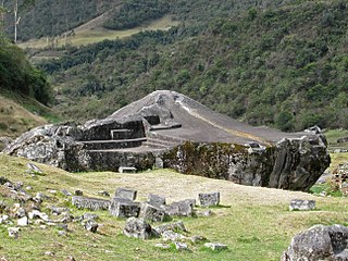
Tampukancha is an ancient Incan religious center located in Peru. It is located in the Cusco Region, Anta Province, Zurite District, about 30 miles from Cusco, the historic capital of the Inca Empire.
Lowland Peruvian Quechua, or Chachapoyas–Lamas Quechua, are Quechuan languages spoken in the lowlands of northern Peru. The two principal varieties are,

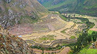
Tarahuasi is an archaeological site in Peru. It is located in the Cusco Region, Anta Province, Limatambo District.
Ñusta Hispana, Ñusta Ispanan, previously known as Chuquipalta is an archaeological site in Peru. It is located at Vilcabamba, La Convención Province, Cusco Region.

Incahuasi or Incawasi is an archaeological site in Peru. It is located in the Lima Region, Cañete Province, Lunahuaná District.

Wayrakancha is a mountain in the Cordillera Central in the Andes of Peru, about 5,300 metres (17,388 ft) high. It is situated in the Junín Region, Yauli Province, Yauli District, and in the Lima Region, Huarochiri Province, Chicla District. Wayrakancha lies northwest of Pumaqucha.

Inti Watana, Intiwatana or Pumaqucha is an archaeological site in Peru. It is located in the Ayacucho Region, Vilcas Huamán Province, Vischongo District, at the lake Pumaqucha.
Collor is an archaeological site in Peru. It is situated in the Cajamarca Region, Cajamarca Province, Namora District. The site lies at a height of about 2,970 metres (9,744 ft) on a mountain named Coyor, east of Lake San Nicolas.
Intipanawin or Intipa Ñawin is an archaeological site and the name of a mountain with rock paintings in Peru. It is situated in the Ancash Region, Bolognesi Province, Pacllon District, at a height of about 3,569 metres (11,709 ft). Beside the painting of the eye of the sun there are also paintings of llamas nearby which draw the attention.
Intikancha is a mountain with an archaeological site of the same name in the Andes of Peru, about 4,400 metres (14,436 ft) high. It is located in the Puno Region, Lampa Province, Nicasio District, and in the San Román Province, Juliaca District.
Pumacancha is a mountain in the Cusco Region in Peru, about 4,547.9 metres (14,921 ft) high. It is situated in the Paucartambo Province, Caicay District.
Wayllakancha is a mountain in the Paryaqaqa mountain range in the Andes of Peru, about 5,400 metres (17,717 ft) high. It is situated in the Junín Region, Yauli Province, in the districts Suitucancha and Yauli. The peaks of Qarwachuku, Wallakancha and Ukhu Qhata lie north-west, north and north-east of Wayllakancha.
Huallacancha or Huallacanecha is a mountain in the Pariacaca mountain range in the Andes of Peru, about 5,500 metres (18,045 ft) high. It is situated in the Junín Region, Yauli Province, on the border of the districts Suitucancha and Yauli. Huallacancha lies south-east of the mountain Qarwachuku, west of the mountain Ukhu Qhata and north of the mountain Wayllakancha.

Canchacanchajasa is a 4,987-metre-high (16,362 ft) mountain in the Urubamba mountain range in the Andes of Peru. It is located in the Cusco Region, Calca Province, Calca District, north of the Urubamba River. Canchacanchajasa is situated southeast of Sirihuani, north of Cóndorhuachana and Huamanchoque and southwest of Sahuasiray. It lies in the upper part of the Cancha Cancha valley (kancha kancha) at the Lares trek.
Carhuascancha or Tumarinaraju is a mountain in the Cordillera Blanca in the Andes of Peru with an elevation of 5,648 metres (18,530 ft) or 5,668 metres (18,596 ft) above sea level. It is situated in the Ancash Region, Huari Province, Huantar District, and in the Huaraz Province, Huaraz District. Carhuascancha lies north-west of Huantsán.
Llamachayuq is an archaeological complex with petroglyphs in Peru. It is located in the Apurímac Region, Andahuaylas Province, San Jerónimo District. The site with images of llamas, vicuñas, felines, people and the sun lies near Lliwpa Pukyu (Lliupapuquio) at a height of 3,449 metres (11,316 ft).
Yuraq Kancha may refer to:


