Intikancha | |
---|---|
Highest point | |
Elevation | 4,400 m (14,400 ft) [1] |
Coordinates | 15°18′50″S70°16′35″W / 15.31389°S 70.27639°W Coordinates: 15°18′50″S70°16′35″W / 15.31389°S 70.27639°W |
Geography | |
Location | Peru, Puno Region, Lampa Province, San Román Province |
Parent range | Andes |
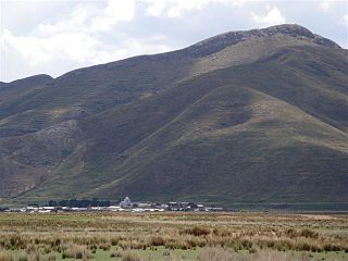
Intikancha (Quechua inti sun, kancha enclosure, enclosed place, yard, a frame, or wall that encloses, [2] "sun yard", hispanicized spelling Inticancha) is a mountain with an archaeological site of the same name in the Andes of Peru, about 4,400 metres (14,436 ft) high. It is located in the Puno Region, Lampa Province, Nicasio District, and in the San Román Province, Juliaca District. [1]
A mountain is a large landform that rises above the surrounding land in a limited area, usually in the form of a peak. A mountain is generally steeper than a hill. Mountains are formed through tectonic forces or volcanism. These forces can locally raise the surface of the earth. Mountains erode slowly through the action of rivers, weather conditions, and glaciers. A few mountains are isolated summits, but most occur in huge mountain ranges.
An archaeological site is a place in which evidence of past activity is preserved, and which has been, or may be, investigated using the discipline of archaeology and represents a part of the archaeological record. Sites may range from those with few or no remains visible above ground, to buildings and other structures still in use.
The Andes or Andean Mountains are the longest continental mountain range in the world, forming a continuous highland along the western edge of South America. This range is about 7,000 km (4,300 mi) long, about 200 to 700 km wide, and of an average height of about 4,000 m (13,000 ft). The Andes extend from north to south through seven South American countries: Venezuela, Colombia, Ecuador, Peru, Bolivia, Chile and Argentina.
The archaeological site of Intikancha was declared a National Cultural Heritage by Resolución Directoral Nacional No. 79. [3] It lies south of the mountain and archaeological site of Pukarani.
Pukarani is a mountain with an archaeological site of the same name in the Andes of Peru, about 4,301.9 m (14,114 ft) high. It is located in the Puno Region, Lampa Province, Nicasio District.
Puno is a department in southeastern Peru. It is bordered by Bolivia on the east, the departments of Madre de Dios on the north, Cusco and Arequipa on the west, Moquegua on the southwest, and Tacna on the south. Its capital is the city of Puno, which is located on Lake Titicaca in the geographical region known as the Altiplano or high sierra.
San Román is a province in the Puno Region of Peru. It borders the provinces of Lampa, Azángaro, Puno, Huancane, the Arequipa Province of the Arequipa Region and Moquegua Region's province of General Sánchez Cerro. Its capital is the city of Juliaca which is also second-largest city of the region.
Lampa province is a province of the Puno region in Peru. Its population is about 40,856. The capital is Lampa.
Sayt'uqucha or Sayt'u Qucha is a lake in Peru located in the Puno Region, Lampa Province, Paratía District. It is situated at a height of about 4,556 metres (14,948 ft), about 3.13 km long and 0.42 km at its widest point. Sayt'uqucha lies between the mountain Yanawara in the northwest and a group of three lakes called Kimsaqucha in the southeast.
Pukara means a ruin of the fortifications made by the natives of the central Andean cultures.
Hatun Pastu is a mountain in the Andes of Peru, about 5,170 metres (16,962 ft) high. It is located in the Puno Region, Lampa Province, on the border of the districts Palca and Paratía, southeast of the mountain Qillqa and north of Waykira.
Yanawara or Mina Punta is a mountain in the Andes of Peru, about 5,465 metres (17,930 ft) high. It is located in the Puno Region, Lampa Province, on the border of the districts Palca and Paratía. Yanawara lies northwest of the lake Sayt'uqucha.
Qillqa is a mountain in the Andes of Peru, about 5,350 metres (17,552 ft) high. It is located in the Puno Region, Lampa Province, on the border of the districts Palca and Paratía. Qillqa lies northwest of the mountains Yanawara, Waykira and Hatun Pastu.
Yanawara may refer to:
Intikancha is a mountain in the Andes of Peru, about 4,700 metres (15,420 ft) high. It is situated in the Apurímac Region, Grau Province, in the south of the Progreso District.
Pachakutiq is a mountain in the Andes of Peru, about 5,000 metres (16,404 ft) high. It is located in the Puno Region, Lampa Province, Paratía District. Pachakutiq is situated southwest of the mountain Yanawara, west of the lake Sayt'uqucha and north of the mountain Aqup'ukru.
Aqup'ukru is a 4,997-metre-high (16,394 ft) mountain in the Andes of Peru. It is located in the Puno Region, Lampa Province, Paratía District. Aqup'ukru is situated south of the mountain Yanawara, west of the lake Sayt'uqucha and southeast of the mountain Pachakutiq.
Machu Kunturi or Pampachuku(Pampachuco) is a mountain in the Andes of Peru, about 5,100 metres (16,732 ft) high. It is located in the Puno Region, Lampa Province, Ocuviri District. Machu Kunturiri lies between the mountain Pichaqani in the west and Qillqa in the east.
Kuntur Sayana is a mountain in the Andes of Peru, about 5,000 metres (16,404 ft) high. It is located in the Puno Region, Lampa Province, Paratía District.
Puka Punchu is a mountain in the Andes of Peru, about 5,000 m (16,000 ft) high. It is situated in the Puno Region, Lampa Province, on the border of the districts of Ocuviri and Santa Lucía. Puka Punchu lies southeast of Qullqi Q'awa.
Pukara is a mountain in the Andes of Peru, about 4,200-metre (13,800 ft) high, with an archaeological site on top. It is located in the Puno Region, Sandia Province, Patambuco District, southwest of Patambuco. The pre-Inca funerary site is also known as Trinchera. The place was declared a National Cultural Heritage by Resolución Directoral Nacional No. 296/INC-2003 by the National Institute of Culture. It consists of tombs, walls, houses, squares and tunnels.
Pariwana is a 5,022-metre-high (16,476 ft) mountain in the Andes of Peru. It is located in the Puno Region, Lampa Province, on the border of the districts of Palca and Vilavila. Pariwana lies north of Qillqa.
Yaritayuq is a mountain in the Andes of Peru, about 4,800 m (15,700 ft) high. It is located in the Puno Region, Lampa Province, on the border of the districts of Palca and Paratia. Yaritayuq lies east of Yanawara.
T'akra is a mountain in the Andes of Peru, about 5,100 m (16,700 ft) high. It is located in the Puno Region, Lampa Province, Ocuviri District. T'akra lies southwest of Qullqa Sirka and northwest of Qillqa and Machu Kunturi.
This Puno Region geography article is a stub. You can help Wikipedia by expanding it. |