Tambo Colorado

Last updated
Tambo Colorado
Puka Tampu
TamboColorado-colours.PNG
Remains of original colours on the Northern Palace adobe walls of Tambo Colorado
Peru physical map.svg
Archaeological site icon (red).svg
Shown within Peru
Alternative namePukallaqta, Pukawasi
Location Ica Region, Peru
Coordinates 13°42′19″S75°49′45″W / 13.70528°S 75.82917°W / -13.70528; -75.82917 Coordinates: 13°42′19″S75°49′45″W / 13.70528°S 75.82917°W / -13.70528; -75.82917
TypeSettlement
Area1.2 ha (3.0 acres)
History
Founded1470
Abandoned1532
Periods Late Horizon
Cultures Inca

Tambo Colorado (Quechua : Pukatampu) is a well-preserved Inca adobe complex near the coast of Peru, also known under the Quechua names Puka Tampu ("red resting place"), Pukallaqta ("red place") or Pukawasi ("red house").

Contents

Location

The site is located just inland from the south coast of Perú in the Pisco River Valley about 40 km along the highway to Ayacucho known as the Via de los Libertadores, close to the town of Pisco. Initial reports from the 2007 Peru earthquake reported no major damage to the site. [1]

A High resolution GPS point was shot at the site datum on 2 Aug 2009 using an L2 GPS (Trimble GeoXH with Zephyr). The post-processed position is as follows: Northings: 8484705.386 m (± 0.8 m) Eastings: 410335.884 m (± 0.8 m) Altitude (MSL): 484.849 m (±1.8 m) UTM Zone 18 South, Datum WGS 1984.

Digital reconstruction of original Inca painting on Room 42 wall, Tambo Colorado. Data is derived from a CyArk/University of California research partnership. Cyark Tambo Colorado Rm42 3.jpg
Digital reconstruction of original Inca painting on Room 42 wall, Tambo Colorado. Data is derived from a CyArk/University of California research partnership.

History

The site was most likely built at the end of the 15th century during the reign of the Inca king Pachacuti Inca Yupanqui also known as Pachacutec, after the annexation of the merchant kingdom of Chincha.

Name

The site owes its name to the abundant use of colors on the walls. Thanks to favorable (very dry) environmental conditions, many walls at Tambo, both internal and external, retain enough residual colored paint to accurately reconstruct what the original wall painting would have been like. Color here was often applied in horizontal strips of red, black, white, and yellow ochre atop stucco, and variation in color would accentuate architectural features such as niches. Trapezoidal niches at Tambo have one or two recesses each, likely used for the placement of important objects. As with all Inca constructions, the overall dimensions of niche construction are standardized across the entire site.

Lay-out

Plan of Northern Palace, Tambo Colorado, cut from a Laser Scan. Data is derived from a CyArk/University of California research partnership Tambo Colorado Plan Cyark.jpg
Plan of Northern Palace, Tambo Colorado, cut from a Laser Scan. Data is derived from a CyArk/University of California research partnership

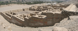
The site consists of several structures around a large central plaza. The central plaza is shaped like a trapezoid with its largest side being 150 m long. The main structures are grouped together in a northern part and a southern part (Sector Norte and Sector Sur). These structures are known as the Northern palace and the two Southern Palaces, flanked by an Ushnu (raised ceremonial platform) and a building known as the Utilities Structure.

The combination of Chincha and Inca architectural techniques can be seen in the place.

Use

It is believed to have been used by the Incas as an administrative and control site on the main road from the coast to the highlands.

Museum

A small on-site museum is located near the entrance of the complex.

TamboColorado-stretched.PNG
A panorama of Tambo Colorado

Notes

  1. Josephs, Leslie (2007-08-22). "Quake causes serious damage to tourist sites, nature reserve closed". International Herald Tribune. Retrieved 2008-02-05.

Related Research Articles

<span class="mw-page-title-main">Cusco</span> City in Peru

Cusco, often spelled Cuzco, is a city in Southeastern Peru near the Urubamba Valley of the Andes mountain range. It is the capital of the Cusco Region and of the Cusco Province. The city is the seventh most populous in Peru; in 2017, it had a population of 428,450. Its elevation is around 3,400 m (11,200 ft).

Pachacámac is an archaeological site 40 kilometres (25 mi) southeast of Lima, Peru in the Valley of the Lurín River. The site was first settled around A.D. 200 and was named after the "Earth Maker" creator god Pacha Kamaq. The site flourished for about 1,300 years until the Spanish invaded. Pachacamac covers about 600 hectares of land.

<span class="mw-page-title-main">Pisco, Peru</span> City in Ica, Peru

Pisco is a city located in the Department of Ica of Peru, the capital of the Pisco Province. The city is around 9 metres above sea level. Pisco was founded in 1640, close to the indigenous emplacement of the same name. Pisco originally prospered because of its nearby vineyards and became noted for its grape brandy or pisco which was exported from its port. Pisco has an estimated population of 104,656.

<span class="mw-page-title-main">Department of Ica</span> First-level administrative division on the southwestern coast of Peru

Ica is a department and region of Peru. It borders the Pacific Ocean on the west; the Lima Region on the north; the Huancavelica and Ayacucho regions on the east; and the Arequipa Region on the south. Its capital is the city of Ica.

<span class="mw-page-title-main">Department of Moquegua</span> Departments of Peru

Moquegua is a department and region in southern Peru that extends from the coast to the highlands. Its capital is the city of Moquegua, which is among the main Peruvian cities for its high rates of GDP and national education.

<span class="mw-page-title-main">Ica, Peru</span> Place in Ica, Peru

Ica is a city and the capital of the Department of Ica in southern Peru. While the area was long inhabited by varying cultures of indigenous peoples, the Spanish conquistador Jerónimo Luis de Cabrera claimed its founding in 1563.

<span class="mw-page-title-main">Sacsayhuamán</span> Archaeological site near Cusco, Peru

Sacsayhuamán, which can be spelled many different ways, is a citadel on the northern outskirts of the city of Cusco, Peru, the historic capital of the Inca Empire.

<span class="mw-page-title-main">Ollantaytambo</span> Archaeological site in Peru

Ollantaytambo is a town and an Inca archaeological site in southern Peru some 72 km (45 mi) by road northwest of the city of Cusco. It is located at an altitude of 2,792 m (9,160 ft) above sea level in the district of Ollantaytambo, province of Urubamba, Cusco region. During the Inca Empire, Ollantaytambo was the royal estate of Emperor Pachacuti, who conquered the region, and built the town and a ceremonial center. At the time of the Spanish conquest of Peru, it served as a stronghold for Manco Inca Yupanqui, leader of the Inca resistance. Nowadays, located in what is called the Sacred Valley of the Incas, it is an important tourist attraction on account of its Inca ruins and its location en route to one of the most common starting points for the four-day, three-night hike known as the Inca Trail.

<span class="mw-page-title-main">Chincha culture</span> Native American culture

The Chincha culture was the culture of a Native Peruvian people living near the Pacific Ocean in south west Peru. The Chincha Kingdom and their culture flourished in the Late Intermediate Period, also known as the regional states period of pre-Columbian Peru. They became part of the Inca Empire around 1480. They were prominent as sea-going traders and lived in a large and fertile oasis valley. La Centinela is an archaeological ruin associated with the Chincha. It is located near the present-day city of Chincha Alta.

<span class="mw-page-title-main">El Fuerte de Samaipata</span> Archaeological site in Bolivia

El Fuerte de Samaipata or Fort Samaipata, also known simply as "El Fuerte", is a Pre-Columbian archaeological site and UNESCO World Heritage Site located in Florida Province, Santa Cruz Department, Bolivia. It is situated in the eastern foothills of the Bolivian Andes and is a popular tourist destination for Bolivians and foreigners alike. It is served by the nearby town of Samaipata. The archaeological site at El Fuerte is unique as it encompasses buildings of three different cultures: Chanè, Inca, and Spanish.

<span class="mw-page-title-main">Choquequirao</span> Archaeological site in Peru

Choquequirao is an Incan site in southern Peru, similar in structure and architecture to Machu Picchu. The ruins are buildings and terraces at levels above and below Sunch'u Pata, the truncated hill top. The hilltop was anciently leveled and ringed with stones to create a 30 by 50 m platform.

<span class="mw-page-title-main">Tambo (Incan structure)</span> Inca military and administrative structure

A tambo was an Incan structure built for administrative and military purposes. Found along the extensive roads, tambos typically contained supplies, served as lodging for itinerant state personnel, and were depositories of quipu-based accounting records. Individuals from nearby communities within the Inca empire were conscripted to maintain and serve in the tambos, as part of the mit'a labor system. Tambos were spaced along Incan roads, generally about one day's travel apart.

<span class="mw-page-title-main">Inca army</span>

The Inca army was the multi-ethnic armed forces used by the Tawantin Suyu to expand its empire and defend the sovereignty of the Sapa Inca in its territory.

<span class="mw-page-title-main">Chincha Alta</span> Town in Ica, Peru

Chincha Alta is a Peruvian city located in the Ica Region. It is the capital of Chincha Province.

<span class="mw-page-title-main">Tipón</span> Archaeological park in Peru near Cusco with an Incan monumental hydraulic system

Tipón, is a sprawling early fifteenth-century Inca archaeological park that is situated between 3,250 metres (10,660 ft) and 3,960 metres (12,990 ft) above sea level, located 22 kilometres (14 mi) southeast of Cusco near the village of Tipón. It consists of several ruins enclosed by a powerful defensive wall about 6 kilometres (3.7 mi) long. The most renown part of the park is the group of precise and right angled monumental terraces irrigated by a network of water canals fed by a monumental fountain channeling water from a natural spring. The site includes ancient residential areas and a remarkable amount of petroglyphs in its upper part.

<span class="mw-page-title-main">Puka Pukara</span> Archaeological site in Peru

Puka Pukara is a site of military ruins in Peru situated in the Cusco Region, Cusco Province, Cusco District, near Cusco. This fort is made of large walls, terraces, and staircases and was part of defense of Cusco in particular and the Inca Empire in general.

<span class="mw-page-title-main">Band of Holes</span> Archaeological site in Peru

The Band of Holes, also known in Spanish as Monte Sierpe or Cerro Viruela, is a series of about 5,000–6,000 man-sized holes found in the Pisco Valley on the Nazca Plateau in Peru. Local people have no idea who made them or how they were used. Over the years, it has been speculated that they were graves, defensive positions, or storage places. Recent thought is that they were storage pits built during the time of the Inca Empire (1438–1533).

<span class="mw-page-title-main">Huánuco Pampa</span> Archaeological site in Peru

Huánuco Pampa, Huánuco Marka or Huánuco Viejo, or Wanuku Pampa is a large archaeological site in Peru in the Huánuco Region, Dos de Mayo Province, La Unión District. The ruins of the city lie on a plateau above the Urqumayu or Vizcarra River in the central Andes. The Incas administered their large empire through a small number of administrative centers, such as Huánuco Pampa. The administrative centers were linked by the extensive Inca road system. The most important of the roads, the Qhapaq Ñan, which ran from Cusco to Quito, passed through Huánuco Pampa. The Inca authorities in Huánuco ruled at least five, and perhaps more, ethnic groups. The city is situated on an important commercial trade route and sits on top of a plateau with ravines on all sides in order to allow easy defense of the city. During the Spanish conquest of the Incas, Huánuco Pampa was briefly occupied by Gomez de Alvarado, who founded a Spanish city there but it was quickly moved because of the harsh climate and Inca raids of Illa Tupac, one of the captains of Manco Inca.

<span class="mw-page-title-main">Plaza de Armas (Cusco)</span> Square in Cusco, Peru

The Plaza de Armas of Cusco is located in the city of Cusco, Peru. Located in the historic center of the city is the main public space of the town since before its Spanish foundation in 1534.

<span class="mw-page-title-main">Tambo Viejo</span> Archaeological site in Peru

Tambo Viejo is an archaeological site that extends over approximately 44 hectares in the north of the Arequipa region of southern Peru. The site presents evidence of human occupation from the Early Intermediate period, including examples of Early Nasca pottery, to structures of the Inca period and remains from the Spanish colonial period.