
Machu Picchu is a 15th-century Inca citadel located in the Eastern Cordillera of southern Peru on a mountain ridge at 2,430 meters (7,970 ft). Often referred to as the "Lost City of the Incas", it is the most familiar icon of the Inca Empire. It is located in the Machupicchu District within the Urubamba Province above the Sacred Valley, which is 80 kilometers (50 mi) northwest of the city of Cusco. The Urubamba River flows past it, cutting through the Cordillera and creating a canyon with a subtropical mountain climate.

Ancash is a department and region in western Peru. It is bordered by the departments of La Libertad on the north, Huánuco and Pasco on the east, Lima on the south, and the Pacific Ocean on the west. Its capital is the city of Huaraz, and its largest city and port is Chimbote. The name of the region originates from the Quechua word anqash, from anqas ('blue') or from anka ('eagle').

The Inca road system was the most extensive and advanced transportation system in pre-Columbian South America. It was about 40,000 kilometres (25,000 mi) long. The construction of the roads required a large expenditure of time and effort.

Arequipa is a department and region in southwestern Peru. It is the sixth largest department in Peru, after Puno, Cuzco, Madre de Dios, Ucayali, and Loreto, its sixth most populous department, and its eleventh least densely populated department. It is bordered by the departments of Ica, Ayacucho, Apurímac and Cusco in the north, the Department of Puno in the east, the Department of Moquegua in the south, and the Pacific Ocean in the west. Its capital, also called Arequipa, is Peru's second-largest city.
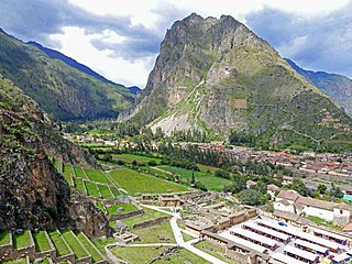
Ollantaytambo is a town and an Inca archaeological site in southern Peru some 72 km (45 mi) by road northwest of the city of Cusco. It is located at an altitude of 2,792 m (9,160 ft) above sea level in the district of Ollantaytambo, province of Urubamba, Cusco region. During the Inca Empire, Ollantaytambo was the royal estate of Emperor Pachacuti, who conquered the region, and built the town and a ceremonial center. At the time of the Spanish conquest of Peru, it served as a stronghold for Manco Inca Yupanqui, leader of the Inca resistance. Located in the Sacred Valley of the Incas, it is now an important tourist attraction on account of its Inca ruins and its location en route to one of the most common starting points for the four-day, three-night hike known as the Inca Trail.

The Colca Canyon is a canyon of the Colca River in southern Peru, located about 160 kilometres (99 mi) northwest of Arequipa. With a depth of about 1000 – 2000 m, it is one of the deepest canyons in the world. Its length is about 70 kilometres (43 mi). The Colca Valley is a colorful Andean valley with pre-Inca rooted inhabitants, and towns founded in Spanish colonial times, still inhabited by people of the Collagua and the Cabana cultures. The local people maintain their ancestral traditions and continue to cultivate the pre-Inca stepped terraces, called andenes.

Antisuyu was the eastern part of the Inca Empire which bordered on the modern-day Upper Amazon region which the Anti inhabited. Along with Chinchaysuyu, it was part of the Hanan Suyukuna or "upper quarters" of the empire, constituting half of the Tahuantinsuyu, the "four parts bound together" that comprised the empire.

Historic roads are paths or routes that have historical importance due to their use over a period of time. Examples exist from prehistoric times until the early 20th century. They include ancient trackways, long-lasting roads, important trade routes, and migration trails. Many historic routes, such as the Silk Road, the Amber Road, and the Royal Road of the Persian Empire, covered great distances and their impact on human settlements remain today.

The Chincha culture was the culture of a Native Peruvian people living near the Pacific Ocean in south west Peru. The Chincha Kingdom and their culture flourished in the Late Intermediate Period, also known as the regional states period of pre-Columbian Peru. They became part of the Inca Empire around 1480. They were prominent as sea-going traders and lived in a large and fertile oasis valley. La Centinela is an archaeological ruin associated with the Chincha. It is located near the present-day city of Chincha Alta.
Mameria is an area of high-elevation jungle to the northeast of the Paucartambo range in southeast Peru, drained by the Mameria River, an affluent of the Nistrón River. Until the 1960s this remote and sparsely populated area would have been considered a part of the Callanga jungle area. Machiguenga peoples, fleeing the slavery that they were subject to along the Yavero River, fled to this area which acquired its current name from the Machiguenga observing that "mameri," which means "there are none," regarding the lack of fish in the river.

PeruRail is a railway operator providing tourist, freight, and charter services in southern Peru. It was founded in 1999 by two Peruvian entrepreneurs and the British company Sea Containers.

The Inca Bridge or Inka Bridge refers to one of two places related to access to Machu Picchu, in Peru.
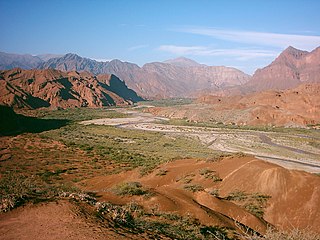
The Calchaquí Valley is an area in the northwestern region of Argentina which crosses the provinces of Catamarca, Tucumán, Jujuy and Salta. It is best known for its contrast of colors and its unique geography that ranges from the mountain desert to the subtropical forest.

Cotahuasi Canyon, near the city of Arequipa in Peru, is one of the deepest canyons in the world. With a depth of approximately 3,354 metres (11,004 ft), as defined as the difference in elevation at river level and the peak of a mountain alongside the canyon, it is more than twice as deep as the Grand Canyon. The Cotahuasi River eroded the canyon between two mountain massifs: the Coropuna and the Solimana. It extends from spurs of the snow-covered Solimana to the confluence with the Ocoña River near the village of Chaucalla.
Callalli District is one of twenty districts of the Caylloma Province in Peru and is located within the geographical area of the Colca Canyon.

Cotahuasi District is one of eleven districts of the province La Unión in Peru.

A qullqa (Quechua pronunciation:[ˈqʊʎˌqa] "deposit, storehouse"; was a storage building found along roads and near the cities and political centers of the Inca Empire. These were large stone buildings with roofs thatched with "ichu" grass, or what is known as Peruvian feathergrass. To a "prodigious [extent] unprecedented in the annals of world prehistory" the Incas stored food and other commodities which could be distributed to their armies, officials, conscripted laborers, and, in times of need, to the populace. The uncertainty of agriculture at the high altitudes which comprised most of the Inca Empire was among the factors which probably stimulated the construction of large numbers of qullqas.
Mawk'allaqta, also Mawk'a Llaqta is an archaeological site in Peru. It is located in the Arequipa Region, La Unión Province, Puyca District, located about 2 kilometers from Puyca.
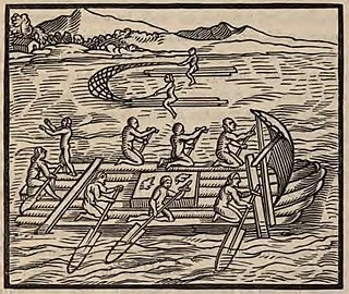
Pre-Columbian rafts plied the Pacific Coast of South America for trade from about 100 BCE, and possibly much earlier. The 16th-century descriptions by the Spanish of the rafts used by Native Americans along the seacoasts of Peru and Ecuador has incited speculation about the seamanship of the Indians, the seaworthiness of their rafts, and the possibility that they undertook long ocean-going voyages. None of the prehistoric rafts have survived and the exact characteristics of their construction and the geographical extent of their voyages are uncertain.
