Sillustani

Last updated
Sillustani
Sillustani, Peru, 2015-08-01, DD 87.JPG
The tallest chullpa of Sillustani, about 12m high
Sillustani
Peru physical map.svg
Archaeological site icon (red).svg
Shown within Peru
Location Puno, Puno Region, Peru
Coordinates 15°43′16″S70°09′30″W / 15.72111°S 70.15833°W / -15.72111; -70.15833
TypeCemetery
History
Cultures Qulla people

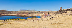
Sillustani is a pre-Inca cemetery on the shores of Lake Umayo near Puno in Peru. The tombs, which are built above ground in tower-like structures called chullpas, are the vestiges of the Qulla people, most likely a Puquina-speaking people [1] , conquered by the Inca Empire in the 15th century.

Contents

The structures housed the remains of complete family groups, although they were probably limited to nobility. Many of the tombs have been dynamited by grave robbers, while others were left unfinished. [2]

Chullpa

Veneration of the dead and kinship were integral parts of Aymara culture, and the huge chullpas or "chupa" at Sillustani were built to house the Aymara elite of the immediate pre-Inca and Inca period. The word was used in the 19th century and comes from the Dictionary of Ludovico Bertonio (1612). Bertonio referred to the basket burials of the semi-nomadic pastoralists as "chulpas" and actually referred to stone towers as uta amaya "houses of the soul". However, the term "chullpa" remains used today for the towers.[ citation needed ]

Many of the chullpas at Sillustani show pre-Inca characteristics that were later redressed with Inca stone blocks. Similar chullpas are found throughout the entire south Central Andes with the above ground burial styles going back at least to the mature Tiwanaku period (c. 500–950). [3] The insides of the tombs were built to hold entire groups of people, most likely extended families of the Aymara elite. Corpses were not intentionally mummified, but in the dry environment created by the closed tomb, they survived for centuries. Most mummy bundles indicate burial in a fetal position. Some of the tombs also have various animal shapes carved into the stone. The only openings to the buildings face east, where it was believed the Sun was reborn by Mother Earth each day. [4]

Architecture

While chullpas are not unique to Sillustani and are found across the Altiplano, this site is considered the best and most preserved example of them. A large ramp on one of the chullpas demonstrates how stones would have been stacked upon the walls during construction. Father Cobo saw Inca builders using a similar ramp in the construction of the Cusco Cathedral. [5]

Overview Sillustani Overview.jpg
Overview

Related Research Articles

Viracocha is the great creator deity in the pre-Inca and Inca mythology in the Andes region of South America. According to the myth Viracocha had human appearance and was generally considered as bearded. According to the myth he ordered the construction of Tiwanaku. It is also said that he was accompanied by men also referred to as Viracochas.

Pachacámac is an archaeological site 40 kilometres (25 mi) southeast of Lima, Peru in the Valley of the Lurín River. The site was first settled around A.D. 200 and was named after the "Earth Maker" creator god Pacha Kamaq. The site flourished for about 1,300 years until the Spanish invaded. Pachacamac covers about 600 hectares of land.

<span class="mw-page-title-main">Tiwanaku</span> Archaeological site in Bolivia

Tiwanaku is a Pre-Columbian archaeological site in western Bolivia, near Lake Titicaca, about 70 kilometers from La Paz, and it is one of the largest sites in South America. Surface remains currently cover around 4 square kilometers and include decorated ceramics, monumental structures, and megalithic blocks. It has been conservatively estimated that the site was inhabited by 10,000 to 20,000 people in AD 800.

<span class="mw-page-title-main">Aymara people</span> Ethnic group

The Aymara or Aimara, people are an indigenous people in the Andes and Altiplano regions of South America. Approximately 2.3 million Aymara live in northwest Argentina, Bolivia, Chile, and Peru. The ancestors of the Aymara lived in the region for many centuries before becoming a subject people of the Inca Empire in the late 15th or early 16th century, and later of the Spanish in the 16th century. With the Spanish American wars of independence (1810–1825), the Aymaras became subjects of the new nations of Bolivia and Peru. After the War of the Pacific (1879–1883), Chile annexed territory with the Aymara population.

<span class="mw-page-title-main">Wari culture</span> Pre-Inca Culture, c. 500 BCE–1000 CE

The Wari were a Middle Horizon civilization that flourished in the south-central Andes and coastal area of modern-day Peru, from about 500 to 1000 AD.

<span class="mw-page-title-main">Chachapoya culture</span> Andean culture

The Chachapoyas, also called the "Warriors of the Clouds", was a culture of the Andes living in the cloud forests of the southern part of the Department of Amazonas of present-day Peru. The Inca Empire conquered their civilization shortly before the Spanish conquest in the 16th century. At the time of the arrival of the conquistadors, the Chachapoyas were one of the many nations ruled by the Incas, although their incorporation had been difficult due to their constant resistance to Inca troops.

<span class="mw-page-title-main">Ollantaytambo</span> Archaeological site in Peru

Ollantaytambo is a town and an Inca archaeological site in southern Peru some 72 km (45 mi) by road northwest of the city of Cusco. It is located at an altitude of 2,792 m (9,160 ft) above sea level in the district of Ollantaytambo, province of Urubamba, Cusco region. During the Inca Empire, Ollantaytambo was the royal estate of Emperor Pachacuti, who conquered the region, and built the town and a ceremonial center. At the time of the Spanish conquest of Peru, it served as a stronghold for Manco Inca Yupanqui, leader of the Inca resistance. Located in the Sacred Valley of the Incas, it is now an important tourist attraction on account of its Inca ruins and its location en route to one of the most common starting points for the four-day, three-night hike known as the Inca Trail.

<span class="mw-page-title-main">Pre-Columbian art</span> Art of the Pre-Columbian civilizations

Pre-Columbian art refers to the visual arts of indigenous peoples of the Caribbean, North, Central, and South Americas from at least 13,000 BCE to the European conquests starting in the late 15th and early 16th centuries. The pre-Columbian era continued for a time after these in many places, or had a transitional phase afterwards. Many types of perishable artifacts that were once very common, such as woven textiles, typically have not been preserved, but Precolumbian monumental sculpture, metalwork in gold, pottery, and painting on ceramics, walls, and rocks have survived more frequently.

<span class="mw-page-title-main">Inca architecture</span> Pre-Columbian architecture in South America

Inca architecture is the most significant pre-Columbian architecture in South America. The Incas inherited an architectural legacy from Tiwanaku, founded in the 2nd century B.C.E. in present-day Bolivia. A core characteristic of the architectural style was to use the topography and existing materials of the land as part of the design. The capital of the Inca empire, Cuzco, still contains many fine examples of Inca architecture, although many walls of Inca masonry have been incorporated into Spanish Colonial structures. The famous royal estate of Machu Picchu is a surviving example of Inca architecture. Other significant sites include Sacsayhuamán and Ollantaytambo. The Incas also developed an extensive road system spanning most of the western length of the continent and placed their distinctive architecture along the way, thereby visually asserting their imperial rule along the frontier.

<span class="mw-page-title-main">Isla del Sol</span> Island in the southern part of Lake Titicaca

Isla del Sol is an island in the southern part of Lake Titicaca. It is part of Bolivia, and specifically part of the La Paz Department. Geographically, the terrain is harsh; it is a rocky, hilly island with many eucalyptus trees. There are no motor vehicles or paved roads on the island. The main economic activity of the approximately 800 families on the island is farming, with fishing and tourism augmenting the subsistence economy. Of the several villages, Yumani and Challapampa are the largest.

<span class="mw-page-title-main">Puquina language</span> Language family of South America

Puquina is a small, putative language family, often portrayed as a language isolate, which consists of the extinct Puquina language and Kallawaya, although it is assumed that the latter is just a remnant of the former mixed with Quechuan. Puquina speakers are last mentioned in the early nineteenth century.

<span class="mw-page-title-main">Chullpa</span> Ancient Aymara funerary tower

A chullpa is an ancient Aymara funerary tower originally constructed for a noble person or noble family. Chullpas are found across the Altiplano in Peru and Bolivia. The tallest are about 12 metres (39 ft) high.

<span class="mw-page-title-main">Chakana</span> Andean symbol

The Chakana is a stepped cross motif used by the Inca and pre-incan Andean societies. The most commonly used variation of this symbol today is made up of an equal-armed cross indicating the cardinal points of the compass and a superimposed square. Chakana means 'bridge', and means 'to cross over' in Quechua. The Andean cross motif appears in pre-contact artifacts such as textiles and ceramics from such cultures as the Chavín, Wari, Chancay, and Tiwanaku, but with no particular emphasis and no key or guide to a means of interpretation. The anthropologist Alan Kolata calls the Andean cross "one of the most ubiquitous, if least understood elements in Tiwanaku iconography". The Andean cross symbol has a long cultural tradition spanning 4,000 years up to the Inca Empire.

<span class="mw-page-title-main">Pumapunku</span> Terraced platform mound in Bolivia

Pumapunku or Puma Punku is a 6th-century T-shaped and strategically aligned man-made terraced platform mound with a sunken court and monumental structure on top. It is part of the Pumapunku complex, at the Tiwanaku Site near Tiwanacu, in western Bolivia. The Pumapunku complex is a collection of plazas and ramps centered on the Pumapunku platform mound. Today only the ruins of the monumental complex on top of the Puma Punku platform mound remain.

<span class="mw-page-title-main">Andean civilizations</span> Civilizations of South Americas Andes Mountains

The Andean civilizations were South American complex societies of many indigenous people. They stretched down the spine of the Andes for 4,000 km (2,500 mi) from southern Colombia, to Ecuador and Peru, including the deserts of coastal Peru, to north Chile and northwest Argentina. Archaeologists believe that Andean civilizations first developed on the narrow coastal plain of the Pacific Ocean. The Caral or Norte Chico civilization of coastal Peru is the oldest known civilization in the Americas, dating back to 3500 BCE. Andean civilizations are one of at least five civilizations in the world deemed by scholars to be "pristine." The concept of a "pristine" civilization refers to a civilization that has developed independently of external influences and is not a derivative of other civilizations.

<span class="mw-page-title-main">Tiwanaku Empire</span> Pre-Columbian polity in Western Bolivia

The Tiwanaku Polity was a Pre-Columbian polity in western Bolivia based in the southern Lake Titicaca Basin. Tiwanaku was one of the most significant Andean civilizations. Its influence extended into present-day Peru and Chile and lasted from around 600 to 1000 AD. Its capital was the monumental city of Tiwanaku, located at the center of the polity's core area in the southern Lake Titicaca Basin. This area has clear evidence for large-scale agricultural production on raised fields that probably supported the urban population of the capital. Researchers debate whether these fields were administered by a bureaucratic state (top-down) or through a federation of communities with local autonomy. Tiwanaku was once thought to be an expansive military empire, based mostly on comparisons to the later Inca Empire. However, recent research suggests that labelling Tiwanaku as an empire or even a state may be misleading. Tiwanaku is missing a number of features traditionally used to define archaic states and empires: there is no defensive architecture at any Tiwanaku site or changes in weapon technology, there are no princely burials or other evidence of a ruling dynasty or a formal social hierarchy, no evidence of state-maintained roads or outposts, and no markets.

<span class="mw-page-title-main">Cerro Baúl</span>

Cerro Baúl is an ancient political outpost and ceremonial center settlement in Peru established by the pre-Incan empire called the Wari. Cerro Baúl is a terraced mountain, 2000 feet above its surroundings, with a settlement on the cliff tops themselves and in the immediate surroundings. Among other finds are the remnants of a brewery and large buildings that may have been used for ceremonial feasting. There is evidence of damage that has been interpreted as a careful and deliberate destruction, by the city's own people, of several buildings prior to the mesa's being vacated.

<span class="mw-page-title-main">Pre-Columbian Bolivia</span>

Pre-Columbian Bolivia covers the historical period between 10,000 BCE, when the Upper Andes region was first populated and 1532, when Spanish conquistadors invaded Inca empire. The Andes region of Pre-Columbian South America was dominated by the Tiwanaku civilization until about 1200, when the regional kingdoms of the Aymara emerged as the most powerful of the ethnic groups living in the densely populated region surrounding Lake Titicaca. Power struggles continued until 1450, when the Incas incorporated upper Bolivia into their growing empire. Based in present-day Peru, the Incas instituted agricultural and mining practices that rivaled those put in place many years later by European conquerors. They also established a strong military force, and centralized political power. Despite their best efforts however, the Incas never completely controlled the nomadic tribes of the Bolivian lowlands, nor did they fully assimilate the Aymara kingdoms into their society. These internal divisions doomed the Inca Empire when European conquerors arrived.

<span class="mw-page-title-main">Colla Kingdom</span>

The Colla, Qolla or Qulla Kingdom was established in the northwestern basin of the Titicaca, one of the Aymara kingdoms that occupied part of the Collao plateau after the fall of Tiwanaku. In the mid-15th century the Collas possessed a vast territory, one of the largest of the Aymara kingdoms, which at the time the 9th Sapan Inka Pachakutiq Yupanqui Qhapaq the Intipchurin, conquered along with other political entities in the region.

<span class="mw-page-title-main">Aymara kingdoms</span> A group of native polities

The Aymara kingdoms, Aymara lordships or lake kingdoms were a group of native polities that flourished towards the Late Intermediate Period, after the fall of the Tiwanaku Empire, whose societies were geographically located in the Qullaw. They were developed between 1150 and 1477, before the kingdoms disappeared due to the military conquest of the Inca Empire. But the current Aymara population is estimated at two million located in the countries of Bolivia, Peru, Chile and Argentina. They used the Aymara and Puquina languages.

References

  1. Cerrón Palomino, Rodolfo (2013-01-01). Las lenguas de los incas: el puquina, el aimara y el quechua. Peter Lang D. doi:10.3726/978-3-653-02485-2. ISBN   978-3-653-02485-2.
  2. Stanish, Charles. Ancient Titicaca. University of Columbia Press. ISBN   0-520-23245-3.
  3. "Chullpas" . Retrieved 19 March 2006.
  4. "Sillustani". Archived from the original on 12 February 2006. Retrieved 18 March 2006.
  5. John Howland Rowe. "Inca Culture At The Time Of The Spanish Coneuqest" (PDF). Retrieved 18 March 2006.