
Arequipa is a department and region in southwestern Peru. It is the sixth largest department in Peru, after Puno, Cuzco, Madre de Dios, Ucayali, and Loreto, its sixth most populous department, and its eleventh least densely populated department. It is bordered by the departments of Ica, Ayacucho, Apurímac and Cusco in the north, the Department of Puno in the east, the Department of Moquegua in the south, and the Pacific Ocean in the west. Its capital, also called Arequipa, is Peru's second-largest city.

The Colca Canyon is a canyon of the Colca River in southern Peru, located about 160 kilometres (99 mi) northwest of Arequipa. With a depth of about 1000 – 2000 m, it is one of the deepest canyons in the world. Its length is about 70 kilometres (43 mi). The Colca Valley is a colorful Andean valley with pre-Inca rooted inhabitants, and towns founded in Spanish colonial times, still inhabited by people of the Collagua and the Cabana cultures. The local people maintain their ancestral traditions and continue to cultivate the pre-Inca stepped terraces, called andenes.

Puno is a province in the Puno Region, in southeastern Peru. It borders the provinces of Huancane, San Román, El Collao and the Moquegua Region's province of General Sánchez Cerro. Its capital is the city of Puno, which is located at the edge of Lake Titicaca, the world's highest navigable lake. It is the economic powerhouse of the region.

Tapacarí is a province in the Cochabamba Department, Bolivia. Its capital is Tapacarí. The province is located at a turnoff from the major highway that links Cochabamba and Oruro. It has traditionally been amongst the poorest in the department. Tapacarí Province and neighboring Arque Province are the two poorest of the 16 provinces that make up the department of Cochabamba.

Chayanta Municipality is the second municipal section of the Rafael Bustillo Province in the Bolivian Potosí Department. It was created on October 8, 1908, during the presidency of Ismael Montes and is now one of four municipalities of the province. Its seat is Chayanta.

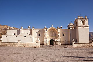
Chivay is a town in the Colca valley, capital of the Caylloma province in the Arequipa region, Peru. Located at about 3,600 m above sea level (12,000 ft), it lies upstream of the renowned Colca Canyon. It has a central town square and an active market. Ten km to the east, and 1,500 metres above the town of Chivay lies the Chivay obsidian source.

Colca River which downstream is called Majes and Camaná is a Peruvian river in the Arequipa Region that flows deep in the rugged Andes of southern Peru. It originates south-east of the village Janq'u Lakaya (Ancolaccaya) in the Callalli District of the Caylloma Province. On its way from Chivay to Cabanaconde it flows through one of the deepest canyons of the world known as the Colca Canyon. Near the town of Camaná the river empties into the Pacific Ocean.

Yunguyo Province is a province of the Puno Region in Peru. The capital of the province is the city of Yunguyo.
Yanque District is one of twenty districts of the province Caylloma in Peru.

The aguayo, or also quepina is a rectangular carrying cloth used in traditional communities in the Andes region of Argentina, Bolivia, Chile, Colombia, Ecuador and Peru. Aymara and Quechua people use it to carry small children or various other items in it on their backs. It is similar to a lliklla and sometimes regarded as a synonym. It is often striped, and is hand woven with wool that is later dyed with bright colors.
Wila Lluxi is a mountain in the Andes, about 5,596 m (18,360 ft) high. It lies in the Cordillera Real of Bolivia in the La Paz Department, Los Andes Province, Batallas Municipality, Kirani Canton. It is situated on the western side of the Janq'u Quta valley next to the mountains Warawarani and Phaq'u Kiwuta. Other prominent mountains nearby are Janq'u Laya and Janq'u Uyu in the north, and Wila Lluxita and Mullu Apachita in the northeast, all of them higher than 5,000 m.

Iñaq Uyu, also called Aklla Wasi, is an archaeological site in Bolivia situated on the Isla de la Luna, an island of Lake Titicaca. It is located in the La Paz Department, Manco Kapac Province, Copacabana Municipality In Incan society, the societal structure was very rigid. Often those of belonging to the royal class structure did not mix with the lower classes.
Jello Jello (possibly from Aymara and Quechua q'illu yellow, the reduplication indicates that there is a group or a complex of something, "a complex of yellow", q'illu q'illu a plant , is a mountain in the Andes of Peru, about 5,220 metres high. It is situated in the Arequipa Region, Caylloma Province, in the districts Callalli and Chivay. Jello Jello lies northeast of a higher mountain named Huarancante. There is a small lake northwest of the mountain named Jello Jello.

Chinkana is an archaeological site in Bolivia situated on the Isla del Sol, an island of Lake Titicaca. It is located in the La Paz Department, Manco Kapac Province, Copacabana Municipality.
Pukara is an archaeological site in Peru. It is located in the Arequipa Region, Caylloma Province, Coporaque District. The ruins consisting of buildings, stone tombs (chullpa), deposits (qullqa) and walls lie on the left side of the road from Chivay to Coporaque.
Ancachita is a mountain in the Andes of Peru, about 5,131.3 metres (16,835 ft) high. It is situated in the Arequipa Region, Caylloma Province, on the border of the districts Callalli and Chivay, east of Chivay. Ancachita lies north of the higher mountains Huarancante and Jello Jello.
Mullu Apachita is a mountain in the Cordillera Real in the Andes of Bolivia, about 5,368 metres (17,612 ft) high. It is located in the La Paz Department at the border of the Larecaja Province, Guanay Municipality, and the Los Andes Province, Batallas Municipality. It is situated southeast of the mountains Wila Lluxita and Janq'u Uyu.
Wiluyu is a mountain in the Andes of southern Peru, about 4,800 metres (15,748 ft) high. It is located in the Puno Region, Puno Province, on the border of the districts Mañazo and Tiquillaca. It lies south of the mountain Chuqi Liwa (Choquelihua).
Wiluyu is a mountain in the Andes of southern Peru, about 4,600 metres (15,092 ft) high. It is located in the Puno Region, Puno Province, Tiquillaca District. It lies between two rivers named Wanuni (Huanuni) and Uqi Jaqhi (Oqueaque), southwest of the mountain K'ara K'arani and southeast of Pura Purani.
Viluyo is a mountain in the Vilcanota mountain range in the Andes of Peru, about 5,200 metres (17,060 ft) high. It is located in the Cusco Region, Canchis Province, Pitumarca District, east of Sibinacocha. It lies south and southwest of Condoriquiña.
