
The Inca Empire, also known as the Incan Empire and the Inka Empire, was the largest empire in pre-Columbian America. Its political and administrative structure is considered by most scholars to have been the most developed in the Americas before Columbus' arrival. The administrative, political and military center of the empire was located in the city of Cusco. The Inca civilization arose from the Peruvian highlands sometime in the early 13th century. Its last stronghold was conquered by the Spanish in 1572.
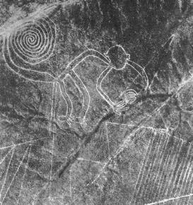
The Nazca Lines are a group of very large geoglyphs formed by depressions or shallow incisions made in the soil of the Nazca Desert in southern Peru. They were created between 500 BCE and 500 CE.

Nazca is a city and system of valleys on the southern coast of Peru. It is also the name of the largest existing town in the Nazca Province. The name is derived from the Nazca culture that flourished in the area between 100 BC and 800 AD. This culture was responsible for the Nazca Lines and the ceremonial city of Cahuachi; they also constructed an impressive system of underground aqueducts, named Puquios, that still function today.
Chinese Peruvians, also known as tusán, are members of a Peruvian ethnic group whose ancestors came from Guangdong Province in China. They are people of Overseas Chinese ancestry born in Peru or who have made Peru their adopted homeland.

A chronology of Jesus aims to establish a timeline for the events of the life of Jesus. Scholars have correlated Jewish and Greco-Roman documents and astronomical calendars with the New Testament accounts to estimate dates for the major events in Jesus's life.

Petroglyph National Monument stretches 17 miles (27 km) along Albuquerque, New Mexico's West Mesa, a volcanic basalt escarpment that dominates the city's western horizon. Authorized June 27, 1990, the 7,236 acre (29.28 km2) monument is cooperatively managed by the National Park Service and the City of Albuquerque. The western boundary of the monument features a chain of dormant fissure volcanoes. Beginning in the northwest corner, Butte volcano is followed to its south by Bond, Vulcan, Black and JA volcanoes.
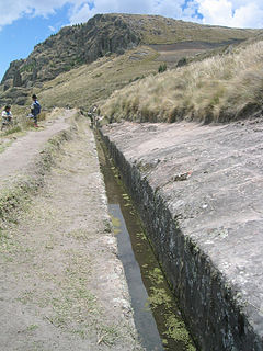
Cumbemayo or Cumbe Mayo is an archaeological site located 20 kilometers southwest of the city of Cajamarca in Peru at 3,500 meters of elevation. Built around 1500 B.C.E, it comprises aqueducts, a grotto and petroglyphs; all within an area of rock formations.

Huascarán is a mountain in the Peruvian province of Yungay, situated in the Cordillera Blanca range of the western Andes. The highest southern summit of Huascarán is the highest point in Peru, the northern part of Andes and in all of the Earth's Tropics. Huascarán is the fourth highest mountain in the Western Hemisphere and South America after Aconcagua, Ojos del Salado, and Monte Pissis. The mountain was named after Huáscar, a 16th-century Inca emperor who was the Sapa Inca of the Inca empire.

Pueblo Bonito is the largest and best-known great house in Chaco Culture National Historical Park, northern New Mexico. It was built by the Ancestral Puebloans who occupied the structure between AD 828 and 1126.
The Mashco-Piro or Mascho Piro, also known as the Cujareño people and Nomole, are an indigenous tribe of nomadic hunter-gatherers who inhabit the remote regions of the Amazon rainforest. They live in Manú National Park in the Madre de Dios Region in Peru. They have in the past actively avoided contact with non-native peoples.

Saimaluu Tash is a petroglyph site in Jalal-Abad Province, Kyrgyzstan, south of Kazarman. Over 10,000 carved pictures—and perhaps as many as 11,000—which are black-and-white rock paintings, have so far been identified, making the site a globally important collection of rock art. They are a sacred display of offerings of the ancient people of the lower valley.
Peruvians of European descent, also known as White Peruvians. An outside estimate gives 15% of the total population. Traditionally, this group has been more dominant in the political, commercial, and diplomatic sectors of Peruvian society. According to the most recent 2017 census where Ethnic Self-identification was used, it makes up about 5.9% of the total population aged 12 yrs and above of Peru.
Asian Peruvians, primarily Chinese and Japanese, constitute some 5-7% of Peru's population, which in proportion to the overall population is one of the largest of any Latin American nation.

In demographics, the world population is the total number of humans currently living, and was estimated to have reached 7.6 billion people as of May 2018. It took over 200,000 years of human history for the world's population to reach 1 billion; and only 200 years more to reach 7 billion.

Painting in the Americas before European colonization is the Precolumbian painting traditions of the Americas. Painting was a relatively widespread, popular and diverse means of communication and expression for both religious and utilitarian purpose throughout the regions of the Western Hemisphere. During the period before and after European exploration and settlement of the Americas; including North America, Central America, South America and the islands of the Caribbean, the Bahamas, the West Indies, the Antilles, the Lesser Antilles and other island groups, indigenous native cultures produced a wide variety of visual arts, including painting on textiles, hides, rock and cave surfaces, bodies especially faces, ceramics, architectural features including interior murals, wood panels, and other available surfaces. Many of the perishable surfaces, such as woven textiles, typically have not been preserved, but Precolumbian painting on ceramics, walls, and rocks have survived more frequently.

Toro Muerto is a collection of ancient petroglyphs in the Peruvian coastal desert, found in the Castilla province in the region Arequipa in Peru. The site contains some 3000 volcanic rocks with petroglyphs dating back to the Wari culture, active from 500 to 1000 CE. The Wari were a Middle Horizon civilization that flourished in the south-central Andes and coastal area of modern-day Peru.

Chauchilla Cemetery is a cemetery that contains prehispanic mummified human remains and archeological artifacts, located 30 kilometres (19 mi) south of the city of Nazca in Peru.

Puyupatamarca or Phuyupatamarca is an archaeological site along the Inca Trail in the Urubamba Valley of Peru. Due to its altitude of roughly 3600 meters, it is known as "La Ciudad entre la Niebla". It contains Inca ruins, with five small stone baths which during the wet season contain constant fresh running water.
Simon son of Boethus was a Jewish High priest in the 1st century BCE and father-in-law of Herod the Great. According to Josephus, he was also known by the name Cantheras. His family is believed to have been connected to the school of the Boethusians, and a family whose origins are from Alexandria in Egypt.


