
Machu Picchu is a 15th-century Inca citadel, located in the Eastern Cordillera of southern Peru, on a mountain ridge 2,430 metres (7,970 ft) above sea level. It is located in the Cusco Region, Urubamba Province, Machupicchu District in Peru, above the Sacred Valley, which is 80 kilometres (50 mi) northwest of Cuzco and through which the Urubamba River flows, cutting through the Cordillera and creating a canyon with a tropical mountain climate.

The Urubamba River or Vilcamayo River is a river in Peru. Upstream it is called Vilcanota River. Within the La Convención Province the naming changes to Urubamba. A partially navigable headwater of the Amazon River, it rises in the Andes to the southeast of Cuzco. It originates on the slopes of Khunurana in the Puno Region, Melgar Province, near the La Raya pass. It flows north-north-west for 724 kilometers before coalescing with the Tambo River to form the Ucayali River.

Machupicchu or Machupicchu Pueblo, also known as Aguas Calientes, is a location in Peru situated in the Cusco Region, Urubamba Province. It is the seat of the Machupicchu District. Machupicchu lies at the Vilcanota River. It is the closest access point to the historical site of Machu Picchu which is 6 kilometres (3.7 mi) away or about a 1.5 hours walk. There are many hotels and restaurants for tourists, as well as natural hot baths which gave the town its colloquial Spanish name. The baths were destroyed by floods several years ago, but have been rebuilt.

Huayna Picchu, Quechua: Wayna Pikchu, is a mountain in Peru around which the Urubamba River bends. It is located in the Cusco Region, Urubamba Province, Machupicchu District. It rises over Machu Picchu, the so-called lost city of the Incas. The Incas built a trail up the side of the Huayna Picchu and built temples and terraces on its top. The peak of Huayna Picchu is 2,693 metres (8,835 ft) above sea level, or about 260 metres (850 ft) higher than Machu Picchu.

Wiñay Wayna is an Inca ruin along the Inca Trail to Machu Picchu. It is built into a steep hillside overlooking the Urubamba River. The site consists of upper and lower house complexes connected by a staircase and fountain structures. Above and below the houses the people built areas of agricultural terraces or andenes, which are still visible.

Putucusi is a round-shaped mountain located on the opposite side (northeast) of the Urubamba River to Machu Picchu in the Cusco Region of Peru. Reaching approximately 2,560 metres (8,400 ft) above sea level at its peak, the mountain offers epic views of Machu Picchu and the surrounding Urubamba River valley.

Huayllabamba District is one of seven districts of the province Urubamba in Peru.

Machupicchu is one of seven districts of the Urubamba Province in Peru. Its seat is the village of Machupicchu.

Patallacta, Llactapata or Q'ente Marka is an archaeological site in Peru located in the Cusco Region, Urubamba Province, Machupicchu District. It is situated southeast of the site Machu Picchu, at the confluence of the rivers Cusichaca and Vilcanota on a mountain named Patallacta.
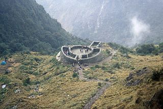
Runkuraqay or Runku Raqay is an archaeological site on a mountain of the same name in Peru located in the Cusco Region, Urubamba Province, Machupicchu District. It is situated southeast of the archaeological site Machu Picchu and south of the Vilcanota river. The ruins lie on the southern slope of the mountain Runkuraqay near the Runkuraqay pass, northeast of the archaeological site Sayacmarca and southeast of the site Qunchamarka.

Qunchamarka is an archaeological site in Peru located in the Cusco Region, Urubamba Province, Machupicchu District, southwest of the mountain Runkuraqay. It lies between the archaeological sites Sayaqmarka and Phuyupatamarka on the Inca Trail to Machu Picchu.
Yanacocha is a lake in Peru located in the Cusco Region, Urubamba Province, Huaylllabamba District. It is about 14 m (46 ft) deep and 240 m (790 ft) long and it is situated at a height of about 3,951 metres (12,963 ft). Yanacocha as well as the nearby lakes named Chaquicocha and Kellococha is known for its woods of polylepis. It is situated high up on the mountain named Chaquicocha.
Kellococha, also spelled Kellococha, Kelloccocha, Quellococha, also Qellococha, Qelloqocha, Q'elloqocha, is a lake in Peru located in the Cusco Region, Urubamba Province, Huaylllabamba District. Kellococha is known for its woods of polylepis which also occur at the neighboring lake named Yanacocha.
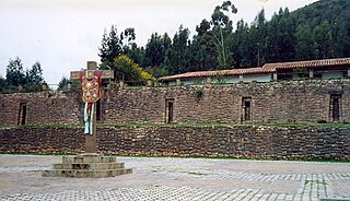
Colcampata is an archaeological site in Peru. It is situated in the Cusco Region, Cusco Province, Cusco District.
Machu Q'inti is an archaeological site in Peru. It is situated in the Cusco Region, Urubamba Province, Machupicchu District. Machu Q'inti is situated above the left bank of the Willkanuta River, near the archaeological sites of Wayna Q'inti, Willkaraqay and Patallaqta which is also named Q'inti Marka.
Wayna Q'inti is an archaeological site in Peru. It is situated in the Cusco Region, Urubamba Province, Machupicchu District. Wayna Q'inti is situated above the left bank of the Willkanuta River, near the archaeological sites of Machu Q'inti, Willkaraqay and Patallaqta which is also named Q'inti Marka.
T'uqu T'uquyuq or Machu Machuyuq is an archaeological site with rock paintings in Peru. It is situated in the Cusco Region, Urubamba Province, Yucay District. The site lies at a height of about 3,150 metres (10,335 ft) on the slopes of the mountain Saywa (Sayhua).
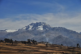
Chaquicocha is a 4,895-metre-high (16,060 ft) mountain at a little lake of that name in the Urubamba mountain range in the Andes of Peru. It is located in the Cusco Region, Calca Province, Calca District, and in the Urubamba Province, in the districts of Huayllabamba and Yucay. It lies southwest of Huamanchoque and southeast of Chicon.

