Calca Province is one of thirteen provinces in the Cusco Region in the southern highlands of Peru. Its seat is Calca.

The Oropesa District is one of the twelve districts in the Quispicanchi Province in Peru. Its capital is the town of Oropesa.

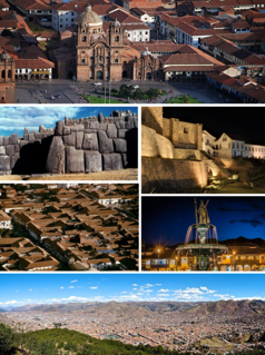
Cusco is a district in the northern Cusco Province within the Cusco Region of Peru. It is bordered by districts of Ccorca and Poroy on the west, the provinces of Anta, the Calca, and Urubamba on the north, the San Jerónimo District on the east, and the districts of Santiago and San Sebastián to the south.

San Salvador District is one of eight districts of the province Calca in Peru.
San Jerónimo District is one of eight districts of the Cusco Province in Peru. It is home to the Universidad Andina del Cusco. According to the 2007 census, there are 31,687 residents in the district. A large part of the population communicates in Quechua.

Ccerayoc is a 5,092-metre-high (16,706 ft) mountain in the Urubamba mountain range in the Andes of Peru. It is located in the Cusco Region, Calca Province, in the districts Calca and Lares. It lies immediately east of Sahuasiray and northeast of Condorhuachana.
Wanakawri is an archaeological site and a legendary mountain in Peru. It is situated in the Cusco Region, Cusco Province, in the districts San Jerónimo and San Sebastián, and in the Paruro Province, Yaurisque District. The mountain with the archaeological remains is 4,089 metres (13,415 ft) high and one of the highest elevations near Cusco.
Killarumiyuq is an archaeological park in Peru. It is located in the Cusco Region, Anta Province, Ancahuasi District. The site was declared a National Cultural Heritage (Patrimonio Cultural) of Peru by Resolución Directoral Nacional No. 150/INC-2003 of March 25, 2003.
Wat'a is an archaeological zone in Peru. It is situated in the Cusco Region, Anta Province, Huarocondo District, north of Huarocondo. The site consists of five sections,

Qhapaq negro is a traditional dance in the Cusco Region in Peru. It is performed at festivals such as Mamacha Carmen in Paucartambo, celebrating Our Lady of Mount Carmel. and the Festividad de la Virgen del Rosario in the town of Huallhua, San Salvador District, Calca Province, Cusco Department.
Purunllacta or Purum Llacta (Quechua purum, purun savage, wild / wasteland, llaqta place is an archaeological site of the Chachapoya culture in Peru. It is situated in the Amazonas Region, Chachapoyas Province, Cheto District, on the mountain of the same name. It lies northeast and near the archaeological site of Purunllacta of the Soloco District.
Quriwayrachina, Quri Wayrachina, Hatun Quriwayrachina or Hatun Quri Wayrachina is an archaeological site of the Inca period in Peru located in the Ayacucho Region, Lucanas Province, Carmen Salcedo District. It lies near the mountain Inka Pallanka which is venerated as an apu by the people of the area. There are two platforms which are known as Hatun Quri Wayrachina and Huch'uy Quri Wayrachina by the locals. On April 20, 2011, the site was declared a National Cultural Heritage by Resolución Viceministerial No. 459-2011-VMPCIC-MC.
Tauja is a 4,039.8-metre-high (13,254 ft) mountain in the Cusco Region in Peru. It is situated in the Calca Province, San Salvador District, and in the Paucartambo Province, Caicay District, northeast of Huaypun. The Vilcanota River flows around its southern and western slopes. In the east the mountain is bordered by the Huancamayo. It is a right tributary of the Vilcanota River. The confluence is south of the mountain.

Huaypun is a mountain in the Cusco Region in Peru, about 4,200 metres (13,780 ft) high. It is situated in the Calca Province, San Salvador District, and in the Quispicanchi Province, Oropesa District. Huaypun lies on the western bank of the Vilcanota River, southeast of Pachatusan and southwest of Tauja.
Wamanilla or Misayuq Pata is an archaeological site in the Ayacucho Region in Peru. It was declared a National Cultural Heritage by Resolución Viceministerial Nº 459-2011-VMPCIC-MC of April 20, 2011. It is situated in the Huanca Sancos Province, Sacsamarca District, and in the Víctor Fajardo Province, Huancaraylla District.
Wallwa Qhata is a mountain in the Cusco Region in Peru, about 4,000 metres (13,123 ft) high. It is situated in the Calca Province, San Salvador District. Wallwa Qhata lies on the right bank of the Willkanuta River. The village of Wallwa (Huallhua) is situated at its feet.
Qhiwar is a mountain in the Cusco Region in Peru, about 4,400 metres (14,436 ft) high. It is situated in the Calca Province, San Salvador District. Qhiwar lies between Hatun Punta in the east and Wallwa Qhata in the southwest.
P'unquchayuq is a mountain in the Cusco Region in Peru, about 4,400 metres (14,436 ft) high. It is situated in the Calca Province, San Salvador District, and in the Paucartambo Province, Caicay District. P'unquchayuq lies south of Hatun Punta and southeast of Qhiwar.
Cheqollo is an archaeological site in Peru. It is located in the Cusco Region, Cusco Province, San Jerónimo District, north of San Jerónimo. The site was declared a National Cultural Heritage (Patrimonio Cultural) by Resolucion Directorial Nacional No. 514/ 2003.