Cumbemayo

Last updated
Cumbemayo
Cumbemayo aqueduct.JPG
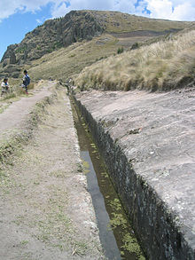
Partial view of aqueduct at Cumbemayo.
Peru physical map.svg
Archaeological site icon (red).svg
Shown within Peru
Alternative nameCumbe Mayo
LocationFlag of Peru.svg  Peru
Cajamarca Province, Cajamarca
Coordinates 07°11′23″S78°34′26″W / 7.18972°S 78.57389°W / -7.18972; -78.57389 Coordinates: 07°11′23″S78°34′26″W / 7.18972°S 78.57389°W / -7.18972; -78.57389
TypeAqueduct, Temple, Petroglyphs
History
BuilderCajamarca culture
Founded1500 BCE
Site notes
ArchaeologistsJulio C. Tello

Cumbemayo or Cumbe Mayo is an archaeological site located 20 kilometers southwest of the city of Cajamarca in Peru at 3,500 meters of elevation. [1] Built around 1500 B.C.E, it comprises aqueducts, a grotto and petroglyphs; all within an area of rock formations. [1]

Contents

History

The aqueduct and the petroglyphs at Cumbemayo are thought to be built circa 1500 - 1000 BC, [1] [2] the petroglpyhs being similar to those of Chavín culture. [2]

Aqueduct

One of the main attractions of Cumbemayo, or "Narrow River" in Cajamarca Quechua, is the aqueduct. This is a canal of approximately 9 km in length, carefully carved in volcanic rock to divert the water from the hills to cultivation fields and a large reservoir; which is presumably originally at the foot of the Santa Apolonia Hill.

Heading towards the aqueduct one can observe some stairways sculpted in stone, and a carved stone which had been used as a ceremonial altar. Also prominent is the Sanctuary a huge cliff resembling a man's head, whose mouth would be a grotto, where interesting but undecipherable petroglyphs have been found. The caves and shelters of the area evidence other stone engravings, where visitors claim to see anthropomorphic images.

Los Frailones, rock formations at Cumbemayo. Bosque de piedras del Cumbemayo 01.jpg
Los Frailones, rock formations at Cumbemayo.

The aqueduct winds down the hills toward the city of Cajamarca, stretching out over about five miles (8.0 km) in length. The canals brought water from the high grounds to the valleys below, which was especially valuable during times of water scarcity. A number of petroglyphs are also scattered around the aqueduct and in surrounding caves. These symbols provide additional insight into the people who constructed the canals. [3]

Los Frailones

Cumbe Mayo petroglyphs Cumbe Mayo Archaeological site - petroglyph.jpg
Cumbe Mayo petroglyphs

Los Frailones are massive volcanic pillars, some stretching as high as 60 feet (18 metres). The stone forests suddenly appear from the landscape, starkly contrasting the flat, grass-covered plains around Cajamarca. The erosive forces of wind and rain likely carved out the pillars.

Many of the pillars, carved by wind and rain have taken on new shapes, resembling hands and even animals, and allowing the mind to wander in the pristine Peruvian setting. Their impressive and rare geological formations, where some will identify the shapes of monks forming part of procession (hence the name frailones, Spanish for friars). [4]

See also

Related Research Articles

Petroglyph Images carved on a rock surface as a form of rock art

A petroglyph is an image created by removing part of a rock surface by incising, picking, carving, or abrading, as a form of rock art. Outside North America, scholars often use terms such as "carving", "engraving", or other descriptions of the technique to refer to such images. Petroglyphs are found worldwide, and are often associated with prehistoric peoples. The word comes from the Greek prefix petro-, from πέτρα petra meaning "stone", and γλύφω glýphō meaning "carve", and was originally coined in French as pétroglyphe.

Prehistoric art Art produced in preliterate cultures

In the history of art, prehistoric art is all art produced in preliterate, prehistorical cultures beginning somewhere in very late geological history, and generally continuing until that culture either develops writing or other methods of record-keeping, or makes significant contact with another culture that has, and that makes some record of major historical events. At this point ancient art begins, for the older literate cultures. The end-date for what is covered by the term thus varies greatly between different parts of the world.

Pontcysyllte Aqueduct

The Pontcysyllte Aqueduct is a navigable aqueduct that carries the Llangollen Canal across the River Dee in the Vale of Llangollen in northeast Wales.

Cajamarca Place in Peru

Cajamarca, also known by the Cajamarca Quechua name, Kashamarka, is the capital and largest city of the Cajamarca Region as well as an important cultural and commercial center in the northern Andes. It is located in the northern highlands of Peru at approximately 2,750 m (8,900 ft) above sea level in the valley of the Mashcon river. Cajamarca had an estimated population of about 226,031 inhabitants in 2015, making it the 13th largest city in Peru.

Longmen Grottoes Cave in Peoples Republic of China

The Longmen Grottoes or Longmen Caves are some of the finest examples of Chinese Buddhist art. Housing tens of thousands of statues of Shakyamuni Buddha and his disciples, they are located 12 kilometres (7.5 mi) south of present-day Luoyang in Henan province, China. The images, many once painted, were carved as outside rock reliefs and inside artificial caves excavated from the limestone cliffs of the Xiangshan (香山) and Longmenshan, running east and west. The Yi River flows northward between them and the area used to be called Yique. The alternative name of "Dragon's Gate Grottoes" derives from the resemblance of the two hills that check the flow of the Yi River to the typical "Chinese gate towers" that once marked the entrance to Luoyang from the south. There are as many as 100,000 statues within the 2,345 caves, ranging from 1 inch (25 mm) to 57 feet (17 m) in height. The area also contains nearly 2,500 stelae and inscriptions, hence the name “Forest of Ancient Stelae", as well as over sixty Buddhist pagodas. Situated in a scenic natural environment, the caves were dug from a 1 kilometre (0.62 mi) stretch of cliff running along both banks of the river. 30% date from the Northern Wei and 60% from the Tang dynasty, caves from other periods accounting for less than 10% of the total. Starting with the Northern Wei Dynasty in 493 AD, patrons and donors included emperors, Wu Zetian, members of the royal family, other rich families, generals, and religious groups.

Hoodoo (geology) A tall, thin spire of relatively soft rock usually topped by harder rock

A hoodoo is a tall, thin spire of rock that protrudes from the bottom of an arid drainage basin or badland. Hoodoos typically consist of relatively soft rock topped by harder, less easily eroded stone that protects each column from the elements. They generally form within sedimentary rock and volcanic rock formations.

Crowley Lake

Crowley Lake is a reservoir on the upper Owens River in southern Mono County, California, in the United States. Crowley Lake is 15 miles south of Mammoth Lakes.

Petroglyph National Monument

Petroglyph National Monument stretches 17 miles (27 km) along Albuquerque, New Mexico's West Mesa, a volcanic basalt escarpment that dominates the city's western horizon. Authorized June 27, 1990, the 7,236 acre (29.28 km2) monument is cooperatively managed by the National Park Service and the City of Albuquerque. The western boundary of the monument features a chain of dormant fissure volcanoes. Beginning in the northwest corner, Butte volcano is followed to its south by Bond, Vulcan, Black and JA volcanoes.

Rock art Human-made markings on natural stone

In archaeology, rock art is human-made markings placed on natural surfaces, typically vertical stone surfaces. A high proportion of surviving historic and prehistoric rock art is found in caves or partly enclosed rock shelters; this type also may be called cave art or parietal art. A global phenomenon, rock art is found in many culturally diverse regions of the world. It has been produced in many contexts throughout human history. In terms of technique, the main groups are: petroglyphs, which are carved or scratched into the rock surface, cave paintings, and sculpted rock reliefs. Another technique creates geoglyphs that are formed on the ground. The oldest known rock art dates from the Upper Palaeolithic period, having been found in Europe, Australia, Asia, and Africa. Anthropologists studying these artworks believe that they likely had magico-religious significance.

Angono Petroglyphs

The Angono Petroglyphs are petroglyphs carved into a rock wall in Angono, Rizal, Philippines. It consists of 127 human and animal figures engraved on the rockwall probably carved during the late Neolithic, or before 2000 BC. They are the oldest known work of art in the Philippines. These inscriptions clearly show stylized human figures, frogs and lizards, along with other designs that may have depicted other interesting figures but erosion may have caused it to become indistinguishable. The engravings are mostly symbolic representations and are associated with healing and sympathetic magic. The site is sacred for indigenous Tagalog folk religion and is believed to be a home for anitos.

Tsankawi

Tsankawi is a detached portion of Bandelier National Monument in New Mexico, near White Rock. It is accessible from a roadside parking area just north of the intersection of East Jemez Road and State Road 4. A self-guided 1.5-mile loop trail provides access to numerous unexcavated ruins, caves carved into soft tuff, and petroglyphs.

Indian rock-cut architecture

Indian rock-cut architecture is more various and found in greater abundance in that country than any other form of rock-cut architecture around the world. Rock-cut architecture is the practice of creating a structure by carving it out of solid natural rock. Rock that is not part of the structure is removed until the only rock left makes up the architectural elements of the excavated interior. Indian rock-cut architecture is mostly religious in nature.

Petrosomatoglyph A supposed image of parts of a human or animal body in rock

A petrosomatoglyph is a supposed image of parts of a human or animal body in rock. They occur all over the world, often functioning as an important form of symbolism, used in religious and secular ceremonies, such as the crowning of kings. Some are regarded as artefacts linked to saints or culture heroes.

Sydney rock engravings

Sydney rock engravings, or Sydney rock art, are a form of Australian Aboriginal rock art in the sandstone around Sydney, New South Wales, Australia, that consist of carefully drawn images of people, animals, or symbols. Many thousands of such engravings are known to exist in the Sydney region, although the locations of most are not publicised to prevent damage by vandalism, and to retain their sanctity, as they are still regarded as sacred sites by Indigenous Australians. There are two art environments in Sydney Basin, rock shelters and engraving sites.

Kamyana Mohyla Archaeological site in Ukraine

Kamyana Mohyla is an archaeological site in the Molochna River valley, about a mile from the village of Terpinnya, Zaporizhzhia Oblast, Ukraine. Petroglyphs of Kamyana Mohyla are dated from Upper Paleolithic to Medieval, with Stone Age depictions subjected to most archaeological interest.

Western Mountains

The Western Mountains or Western Hills are a scenic mountain area located 12 km to the west of Kunming, Yunnan, China. They are formed by the Huating, Taihua and Luohan mountain ranges rising above the eastern and northern banks of Dianchi Lake.

Phong Nha Cave

Phong Nha Cave is a cave in Phong Nha-Kẻ Bàng National Park, a UNESCO World Heritage Site in Quảng Bình Province, Vietnam. It is 7,729 metres long and contains 14 grottoes, as well as a 13,969 metre underground river. While scientists have surveyed 44.5 kilometres of passages, tourists are only allowed to explore the first 1500 metres.

Rumicolca

Rumicolca is an archaeological site in Peru. It is located in the Cusco Region, Quispicanchi Province, Lucre District. Rumicolca is situated near the archaeological sites Chuqi Pukyu and Pikillaqta, east of Lake Huacarpay.

Rock relief

A rock relief or rock-cut relief is a relief sculpture carved on solid or "living rock" such as a cliff, rather than a detached piece of stone. They are a category of rock art, and sometimes found as part of, or in conjunction with, rock-cut architecture. However, they tend to be omitted in most works on rock art, which concentrate on engravings and paintings by prehistoric peoples. A few such works exploit the natural contours of the rock and use them to define an image, but they do not amount to man-made reliefs. Rock reliefs have been made in many cultures throughout human history, and were especially important in the art of the ancient Near East. Rock reliefs are generally fairly large, as they need to be in order to have an impact in the open air. Most of those discussed here have figures that are over life-size, and in many the figures are multiples of life-size.

References

  1. 1 2 3 "COMPLEJO ARQUEOLÓGICO CUMBEMAYO". Mincetur. Retrieved 2018-04-10.
  2. 1 2 DK Eyewitness Travel Guide Peru. Penguin. p. 246. ISBN   9781465458919.
  3. "Cumbe Mayo - Peru." Cumbe Mayo - Peru. AnywherePeru, n.d.
  4. "Cumbemayo Archaeological Complex and The Friars." Cumbemayo Archaeological Complex and The Friars. Go2Peru, n.d