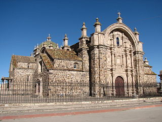
Pukarani | |
---|---|
The village of Nicasio with Pukarani in the background | |
Highest point | |
Elevation | 4,301.9 m (14,114 ft) [1] |
Coordinates | 15°14′28″S70°16′40″W / 15.24111°S 70.27778°W Coordinates: 15°14′28″S70°16′40″W / 15.24111°S 70.27778°W |
Geography | |
Location | Peru, Puno Region, Lampa Province |
Parent range | Andes |
Pukarani (Aymara pukara fortress or a mountain of protection, [2] -ni a suffix to indicate ownership, "the one with a fortress", Hispanicized spelling Pucarani) is a mountain with an archaeological site of the same name in the Andes of Peru, about 4,301.9 m (14,114 ft) high. It is located in the Puno Region, Lampa Province, Nicasio District. [3]
Aymara is an Aymaran language spoken by the Aymara people of the Andes. It is one of only a handful of Native American languages with over one million speakers. Aymara, along with Spanish, is one of the official languages of Bolivia and parts of Peru. It is also spoken, to a much lesser extent, by some communities in northern Chile, where it is a recognized minority language.
Pukara is a defensive hilltop site or fortification built by the prehispanic and historic inhabitants of the central Andean area. In some cases, these sites acted as temporary fortified refuges during periods of increased conflict, while other sites show evidence for permanent occupation. Emerging as a major site type during the Late Intermediate Period, the pukara form was adopted in some areas by the Inca military in contested borderlands of the Inca Empire. The Spanish also referred to the Mapuche earthen forts built during the Arauco War in the 16th and 17th centuries by this term.
In linguistics, a suffix is an affix which is placed after the stem of a word. Common examples are case endings, which indicate the grammatical case of nouns or adjectives, and verb endings, which form the conjugation of verbs.
The archaeological site of Pukarani was declared a National Cultural Heritage by Resolución Directoral Nacional No. 79. [4] It lies north of the mountain and archaeological site of Intikancha.
Lampa province is a province of the Puno Region in Peru. Its population is about 40,856. The capital is Lampa.
Vilavila or Wila Wila is one of ten districts of the province Lampa in Peru.
Pukara means a ruin of the fortifications made by the natives of the central Andean cultures.
Qulu Qulu is an archaeological site in Peru. It is located in the Puno Region, Sandia Province, Patambuco District. The site was declared a National Cultural Heritage (Patrimonio Cultural) of Peru by the National Institute of Culture.
Intikancha is a mountain with an archaeological site of the same name in the Andes of Peru, about 4,400 metres (14,436 ft) high. It is located in the Puno Region, Lampa Province, Nicasio District, and in the San Román Province, Juliaca District.
Wisa Wisa is a mountain in the Andes of Peru, about 4,849.4 metres (15,910 ft) high. It is situated in the Puno Region, Lampa Province, Vilavila District, and in the Melgar Province, Ayaviri District. Wisa Wisa lies near the mountains Pukarani (Pucarani) in the northwest and Wallatani (Huallatane) in the southeast, southwest of a place called Wisa Wisa (Huisa Huisa).
Qullqi is a mountain in the Andes in southern Peru, about 4,916.1 metres (16,129 ft) high. It is situated in the Puno Region, Lampa Province, Pucará District.
Waykira is a mountain in the Andes of Peru, about 5,200 metres (17,060 ft) high. It is located in the Puno Region, Lampa Province, on the border of the districts Palca and Paratía. Waykira lies southeast of the mountain Qillqa and south of Hatun Pastu.
Wankarani is a mountain in the Andes of Peru, about 4,800 metres (15,748 ft) high. It is located in the Puno Region, Lampa Province, Palca District.
Kuntur Ikiña is a mountain in the Andes of Peru, about 4,800 metres (15,748 ft) high. It is located in the Puno Region, Lampa Province, Lampa District.
Phisqa Tira is a mountain in the Andes of Peru, about 5,000 metres (16,404 ft) high. It is located in the Puno Region, Lampa Province, on the border of the districts Paratía and Santa Lucía. Phisqa Tira lies northeast of the mountain Awallani.
Awallani is a mountain in the Andes of Peru, about 4,800 metres (15,748 ft) high. It is located in the Puno Region, Lampa Province, on the border of the districts Paratía and Santa Lucía. Awallani lies between the mountains Phisqa Tira in the northeast and Pukasalla in the southwest.
Wankara is a mountain in the Andes of Peru, about 4,800 metres (15,748 ft) high. It is located in the Puno Region, Lampa Province, on the border of the districts Paratía and Santa Lucía. Wankara lies southwest of the mountains Phisqa Tira, Awallani and Kuntur Ikiña and northwest of Pukasalla.
Mich'i Mich'ini is a 4,826-metre-high (15,833 ft) mountain in the Andes of Peru. It is situated in the Puno Region, Lampa Province, Ocuviri District.
Wini Wini is a mountain in the Andes of Peru, about 4,800 metres (15,748 ft) high. It is situated in the Puno Region, Lampa Province, Ocuviri District.
Chuqi Pirwa is a mountain in the Andes of Peru, about 5,200 m (17,100 ft) high. It is situated in the Cusco Region, Espinar Province, Condoroma District, and in the Puno Region, Lampa Province, Ocuviri District. Chuqi Pirwa lies southwest of Sawanani Lake (Saguanani) and northwest of Qullqi Q'awa.
Pirhuani is a mountain in the Vilcanota mountain range in the Andes of Peru, about 5,000 m (16,000 ft) high. It is located in the Puno Region, Carabaya Province, Corani District. Pirhuani lies southwest of Macho Ritti. It is situated at the Lajamayu valley.
Kirani is a mountain in the Andes of Peru, about 5,000 metres (16,404 ft) high. It is located in the Puno Region, Lampa Province, Paratia District. Kirani lies northeast of Yanawara, east of Ananta Lake.
Kimsa Chuta is a mountain in the Andes of Peru, about 5,050 m (16,570 ft) high. It is located in the Puno Region, Lampa Province, Ocuviri District. Kimsa Chuta lies south of Lamparasi.
Pukarani may refer to:
This Peru mountain, mountain range, or peak related article is a stub. You can help Wikipedia by expanding it. |